Temperatures were above normal across most land and ocean areas in April.
Preliminary data suggest that global average precipitation in April was record low.
Northern Hemisphere snow cover extent tied for lowest on record for the month.
Sea ice extent was below average around both poles.
Global tropical storm activity was near-normal with four named storms.
Map of global selected significant climate anomalies and events in April 2025.
Temperature
Temperatures were above normal across much of the globe in April. Asia and the Arctic stood out in this regard, though western Antarctica was also warmer than normal, and most of the ocean surface was much above average. A few areas were below normal, such as northern Australia, southern South America and eastern Antarctica, as well as the Norwegian, Greenland and Barents Seas.
For the globe as a whole, April 2025 was 2.20°F (1.22°C) above the 20th-century baseline. This is 0.13°F (0.07°C) below the record-warm April of 2024, thus ranking second in the 1850–2025 period. According to NCEI’s Global Annual Temperature Outlook, there is only a 3% chance that 2025 will rank as the warmest year on record.
Surface Temperature Departure from the 1991–2020 Average for April 2025 (°C). Red indicates warmer than average and blue indicates colder than average.
Precipitation
Large areas in central Asia and southern Africa received record-setting precipitation in April. Parts of northern Australia also experienced abnormally high precipitation. Heavy rainfall during the month caused floods and landslides in Brazil and Congo as well as flooding in western Somalia. Despite these extreme events, the globe as a whole was much drier than the long-term average. In fact, preliminary data indicate that April 2025 might have been the driest April in the historical record, which spans from 1979 to present.
Percent of Normal Precipitation from the 1961–1990 base period for April 2025. Brown indicates drier than average and green indicates wetter than average.
Snow Cover
The Northern Hemisphere snow cover extent in April was 820,000 square miles below average, tying with 2024 as the smallest April snow cover extent on record. Snow cover over North America and Greenland was below average (by 120,000 square miles), and Eurasia was also below average (by 710,000 square miles). A lack of snow cover was particularly obvious over the United States and central Eurasia.
Sea Ice
Global sea ice extent was 480,000 square miles below the 1991–2020 average, ranking in the lowest third of the historical record. Arctic sea ice extent was below average (by 160,000 square miles), with the Barents, Okhotsk, Bering and Labrador Seas having lower-than-normal ice extent. Antarctic extent was also below average (by 320,000 square miles), though extent was above normal in some areas (such as the Weddell and Amundsen Seas).
Map of the Arctic (left) and Antarctic (right) sea ice extent in April 2025.
Tropical Cyclones
Four named storms occurred across the globe in April, which matches the long-term average. Most notable among these was Severe Tropical Cyclone Courtney in the southwestern Indian Ocean. Two other storms occurred in the Australian region, along with one in the southwest Pacific.
For a more complete summary of climate conditions and events, see our April 2025 Global Climate Report or explore our Climate at a Glance Global Time Series.
Craters in the lunar surface are visible in this photo taken during the Apollo 11 mission. NASA via AP
April 2025 was a busy month for space.
Pop icon Katy Perry joined five other civilian women on a quick jaunt to the edge of space, making headlines. Meanwhile, another group of people at the United Nations was contemplating a critical issue for the future of space exploration: the discovery, extraction and utilization of natural resources on the Moon.
As a space lawyer and co-founder of For All Moonkind, a nonprofit dedicated to protecting human heritage in outer space, I know that the Moon could be the proving ground for humanity’s evolution into a species that lives and thrives on more than one planet. However, this new frontier raises complex legal questions.
Space, legally
Outer space – including the Moon – from a legal perspective, is a unique domain without direct terrestrial equivalent. It is not, like the high seas, the “common heritage of humankind,” nor is it an area, like Antarctica, where commercial mining is prohibited.
Instead, the 1967 Outer Space Treaty – signed by more than 115 nations, including China, Russia and the United States – establishes that the exploration and use of space are the “province of all humankind.” That means no country may claim territory in outer space, and all have the right to access all areas of the Moon and other celestial bodies freely.
The fact that, pursuant to Article II of the treaty, a country cannot claim territory in outer space, known as the nonappropriation principle, suggests to some that property ownership in space is forbidden.
Can this be true? If your grandchildren move to Mars, will they never own a home? How can a company protect its investment in a lunar mine if it must be freely accessible by all? What happens, as it inevitably will, when two rovers race to a particular area on the lunar surface known to host valuable water ice? Does the winner take all?
As it turns out, the Outer Space Treaty does offer some wiggle room. Article IX requires countries to show “due regard” for the corresponding interests of others. It is a legally vague standard, although the Permanent Court of Arbitration has suggested that due regard means simply paying attention to what’s reasonable under the circumstances.
First mover advantage – it’s a race
The treaty’s broad language encourages a race to the Moon. The first entity to any spot will have a unilateral opportunity to determine what’s legally “reasonable.” For example, creating an overly large buffer zone around equipment might be justified to mitigate potential damage from lunar dust.
On top of that, Article XII of the Outer Space Treaty assumes that there will be installations, like bases or mining operations, on the Moon. Contrary to the free access principle, the treaty suggests that access to these may be blocked unless the owner grants permission to enter.
Both of these paths within the treaty would allow the first person to make it to their desired spot on the Moon to keep others out. The U.N. principles in their current form don’t address these loopholes.
The draft U.N. principles released in April mirror, and are confined by, the language of the Outer Space Treaty. This tension between free access and the need to protect – most easily by forbidding access – remains unresolved. And the clock is ticking.
The Moon’s vulnerable legacy
The U.S. Artemis program aims to return humans to the Moon by 2028, China has plans for human return by 2030, and in the intervening years, more than 100 robotic missions are planned by countries and private industry alike. For the most part, these missions are all headed to the same sweet spot: the lunar south pole. Here, peaks of eternal light and deep craters containing water ice promise the best mining, science and research opportunities.
Regions of the lunar south pole, left, and north pole, right, contain water in the form of ice (blue), which could be useful for space agencies hoping to set up lunar bases. NASA
In this excitement, it’s easy to forget that humans already have a deep history of lunar exploration. Scattered on the lunar surface are artifacts displaying humanity’s technological progress.
More recently, in 2019, China’s Chang’e 4 achieved the first soft landing on the Moon’s far side. And in 2023, India’s Chandrayaan-3 became the first to land successfully near the lunar south pole.
These sites memorialize humanity’s baby steps off our home planet and easily meet the United Nations definition of terrestrial heritage, as they are so “exceptional as to transcend national boundaries and to be of common importance for present and future generations of all humanity.”
The international community works to protect such sites on Earth, but those protection protocols do not extend to outer space.
Astronaut footprints are still intact on the lunar surface because the Moon doesn’t have weather. But nearby spacecraft or rovers could kick up dust and cover them. AP Photo
The more than 115 other sites on the Moon that bear evidence of human activity are frozen in time without degradation from weather, animal or human activity. But this could change. A single errant spacecraft or rover could kick up abrasive lunar dust, erasing bootprints or damaging artifacts.
Protection and the Outer Space Treaty
In 2011, NASA recommended establishing buffer, or safety zones, of up to 1.2 miles (2 kilometers) to protect certain sites with U.S. artifacts.
Because it understood that outright exclusion violates the Outer Space Treaty, NASA issued these recommendations as voluntary guidelines. Nevertheless, the safety zone concept, essentially managing access to and activities around specific areas, could be a practical tool for protecting heritage sites. They could act as a starting point to find a balance between protection and access.
Building on this agreement, the international community could require specific access protocols — such as a permitting process, activity restrictions, shared access rules, monitoring and other controls — for heritage sites on the Moon. If accepted, these protective measures for heritage sites could also work as a template for scientific and operational sites. This would create a consistent framework that avoids the perception of claiming territory.
At this time, the draft U.N. principles released in April 2025 do not directly address the opposing concepts of access and protection. Instead, they defer to Article I of the Outer Space Treaty and reaffirm that everyone has free access to all areas of the Moon and other celestial bodies.
As more countries and companies compete to reach the Moon, a clear lunar legal framework can guide them to avoid conflicts and preserve historical sites. The draft U.N. principles show that the international community is ready to explore what this framework could look like.
Michelle L.D. Hanlon is affiliated with For All Moonkind, a not-for-profit organization committed to protecting human cultural heritage in outer space starting with the Apollo lunar landing sites.
Have you ever imagined what Antarctica looks like beneath its thick blanket of ice? Hidden below are rugged mountains, valleys, hills and plains.
Some peaks, like the towering Transantarctic Mountains, rise above the ice. But others, like the mysterious and ancient Gamburtsev Subglacial Mountains in the middle of East Antarctica, are completely buried.
The Gamburtsev Mountains are similar in scale and shape to the European Alps. But we can’t see them because the high alpine peaks and deep glacial valleys are entombed beneath kilometres of ice.
How did they come to be? Typically, a mountain range will rise in places where two tectonic plates clash with each other. But East Antarctica has been tectonically stable for millions of years.
Our new study, published in Earth and Planetary Science Letters, reveals how this hidden mountain chain emerged more than 500 million years ago when the supercontinent Gondwana formed from colliding tectonic plates.
Our findings offer fresh insight into how mountains and continents evolve over geological time. They also help explain why Antarctica’s interior has remained remarkably stable for hundreds of millions of years.
Because the mountain range is completely covered in ice, it’s one of the least understood tectonic features on Earth. For scientists, it’s deeply puzzling. How could such a massive mountain range form and still be preserved in the heart of an ancient, stable continent?
Most major mountain chains mark the sites of tectonic collisions. For example, the Himalayas are still rising today as the Indian and Eurasian plates continue to converge, a process that began about 50 million years ago.
Plate tectonic models suggest the crust now forming East Antarctica came from at least two large continents more than 700 million years ago. These continents used to be separated by a vast ocean basin.
A map of the topography (a) and surface elevation (b) of Antarctica, measured in metres above sea level; (c) shows ice thickness in metres. Pritchard et al., Scientific Data (2025), CC BY
The collision of these landmasses was key to the birth of Gondwana, a supercontinent that included what is now Africa, South America, Australia, India and Antarctica.
Our new study supports the idea that the Gamburtsev Mountains first formed during this ancient collision. The colossal clash of continents triggered the flow of hot, partly molten rock deep beneath the mountains.
As the crust thickened and heated during mountain building, it eventually became unstable and began to collapse under its own weight.
Deep beneath the surface, hot rocks began to flow sideways, like toothpaste squeezed from a tube, in a process known as gravitational spreading. This caused the mountains to partially collapse, while still preserving a thick crustal “root”, which extends into Earth’s mantle beneath.
Mountain building causes deep crustal rocks to deform, fold and partially melt. Jacqueline Halpin
Crystal time capsules
To piece together the timing of this dramatic rise and fall, we analysed tiny zircon grains found in sandstones deposited by rivers flowing from the ancient mountains more than 250 million years ago. These sandstones were recovered from the Prince Charles Mountains, which poke out of the ice hundreds of kilometres away.
Zircons are often called “time capsules” because they contain minuscule amounts of uranium in their crystal structure, which decays at a known rate and allows scientists to determine their age with great precision.
These zircon grains preserve a record of the mountain-building timeline: the Gamburtsev Mountains began to rise around 650 million years ago, reached Himalayan heights by 580 million years ago, and experienced deep crustal melting and flow that ended around 500 million years ago.
Most mountain ranges formed by continental collisions are eventually worn down by erosion or reshaped by later tectonic events. Because they’ve been preserved by a deep layer of ice, the Gamburtsev Subglacial Mountains are one of the best-preserved ancient mountain belts on Earth.
While it’s currently very challenging and expensive to drill through the thick ice to sample the mountains directly, our model offers new predictions to guide future exploration.
Geologists Jacqueline Halpin and Jack Mulder stand on the Denman Glacier during recent fieldwork. Jacqueline Halpin
For instance, recent fieldwork near the Denman Glacier on East Antarctica’s coast uncovered rocks that may be related to these ancient mountains. Further analysis of these rock samples will help reconstruct the hidden architecture of East Antarctica.
Antarctica remains a continent full of geological surprises, and the secrets buried beneath its ice are only beginning to be revealed.
Jacqueline Halpin receives funding from the Australian Research Council through the ARC Australian Centre for Excellence in Antarctic Science (ACEAS) Special Research Initiative.
Nathan R. Daczko receives funding from the Australian Research Council.
President Donald Trump has begun eroding the United States presence in Antarctica by announcing deep funding cuts to his nation’s science and logistics on the icy continent.
More cuts are foreshadowed. If carried through, US science and overall presence in Antarctica will be seriously diminished – at a time when China is significantly expanding its presence there.
Since 1958, the US has been a leader in both Antarctic diplomacy and science. Shrinking its Antarctic presence will diminish US capacity to influence the region’s future.
Why the US matters in Antarctica
The US has historically focused its Antarctic influence in three key areas:
1. Keeping Antarctica free from military conflict
The US has built considerable Antarctic geopolitical influence since the late 1950s. Under President Dwight D. Eisenhower, it initiated (and later hosted) negotiations that led to the development of the 1959 Antarctic Treaty.
It was also key to establishing the fundamental principles of the treaty, such as using the Antarctic region only for peaceful purposes, and prohibiting military activities and nuclear weapons testing.
2. Governing Antarctica together
The US was influential in developing the international legal system that governs human activities in the Antarctic region.
In the 1970s, expanding unregulated fishing in the Southern Ocean led to serious concerns about the effects on krill-eating species – especially the recovery of severely depleted whale populations.
The US joined other Antarctic Treaty nations to champion the Convention on the Conservation of Antarctic Marine Living Resources (CAMLR), signed in 1980. It prioritises conservation of Southern Ocean ecosystems and all species, over maximum fish harvesting.
The US also contributed to the 1991 Protocol on Environmental Protection. Among other measures it prohibits mining and designates Antarctica as “a natural reserve, devoted to peace and science”.
3. Scientific research and collaboration
The US operates three year‑round Antarctic research stations: Palmer, Amundsen-Scott and McMurdo.
McMurdo is Antarctica’s largest research station. Amundsen-Scott is located at the South Pole, the geographic centre of Antarctica, and the point at which all Antarctic territorial claims meet. The South Pole station is thus important symbolically and strategically, as well as for science.
The US has the largest number of Antarctic scientists of any nation in the continent.
US scientific work has been at the forefront of understanding Antarctica’s role in the global climate system, and how climate change will shape the future of the planet. It has also played a major role in Southern Ocean ecosystem and fisheries research.
This research has underpinned important policies. For example, US input into models to predict and manage sustainable krill yields has been pivotal in regulating the krill fishery, and ensuring it doesn’t harm penguin, seal and whale populations.
The US influence in Antarctica extends beyond the list above. For example, the US has a significant Antarctic-based space program. And US citizens make up most Antarctic tourists, and the US plays a significant role in regulating tourism there.
The full extent of the Trump administration’s cuts is still to play out. But clearly, if they proceed as signalled, the cuts will be a major blow not to just US interests in Antarctica, but those of many other countries.
The US has the best-resourced logistics network in Antarctica. Its air transport, shipping and scientific field support has traditionally been shared by other countries. New Zealand, for instance, is closely tied with the US in resupply of food and fuel, and uses US air and sea logistics for many operations to the Ross Sea region.
And joint research programs with the US will be affected by reduced funding in Antarctica directly, and elsewhere.
For example, reported cuts to the climate programs of NASA and the National Oceanic and Atmospheric Administration (NOAA) may hamper satellite coverage of the Antarctic and Southern Ocean. This would affect Australian scientists collecting data on ocean temperature, sea-ice state and other metrics used in climate research and weather forecasting.
Worrying times ahead
China has signalled its intention to be a key geopolitical player in Antarctica and has greatly expanded its Antarctic presence in recent years.
Both China and Russia, are increasingly active in their opposition to environmental initiatives such as marine protected areas.
A smaller US presence creates greater opportunities for others to shape Antarctica’s geopolitics. This includes pressure to erode decades-long protection of the Antarctic environment, a push for more intensive fish and krill harvesting, and potentially reopening debate on mining in the region.
Lynda Goldsworthy and Tony Press co-authored the chapter Power at the Bottom of the World in the new book Antarctica and the Earth System.
Lynda Goldsworthy, research associate with IMAS, UTAS, undertakes occasional contract work with the Deep Sea Conservation, is a member of AFMA’s SouthMac advisory group ) and of CSIRO National Benefit Advisory Committee.
Tony Press receives funding from the Australia-Japan Foundation (Department of .Foreign Affairs and Trade)
Source: Australian Criminal Intelligence Commission
The first 150 metres of a planned 3000 metre-long Antarctic ice core has been safely returned to Australia after a successful drilling season for the Million Year Ice Core (MYIC). The ice core, in one metre-lengths, contains a record of the past 4000 years of climate history. The core was drilled at a deep field camp at Dome C North, about 1200 km “up the hill” from Australia’s Casey research station. It’s just the start of an ambitious Australian Antarctic Program drilling effort to extract the world’s oldest, continuous ice core record of up to two million years. MYIC science lead, Dr Joel Pedro, said the full-length ice core is expected to extend the current ice core climate record well beyond 1.2 million years, and help solve a climate mystery. “About one million years ago the cycle of ice ages shifted from a regular 41,000 year glacial-interglacial cycle, to a cycle every 100,000 years,” Dr Pedro said. “An ice core record of over one million years can help us answer why that shift in the climate state occurred, and that will provide really important information to test models and better predict climate in the future.”
After a few years of weather and Covid-related delays to drilling, Dr Pedro said the science team, alongside a supporting tractor-traverse team, were relieved to achieve everything they had hoped for this season, thanks to a joint, multi-skilled, team effort. “Our number one priority was to progress the pilot drilling for the MYIC borehole, but to do that we first had to set up the drill shelter,” Dr Pedro said. “We joined forces with the traverse team and were able to get the shelter constructed in 10 days – half the time we expected – and our drill built and tested in parallel. “Then we split in to two shifts to run the drill 16 hours a day, with the traverse team joining us in drilling and core processing. “After so much effort by so many people, and so much planning and time, it was a very special moment for me to pull out that first ice core – to the point that I had a tear in my eye.” Independent living Traverse Field Leader, Chris Gallagher, led a team of mechanics, electricians, a carpenter and a doctor, that towed equipment and supplies to the drill site. Using snow-groomers, and tractors towing sleds carrying 600 tonnes of gear, the team travelled 18 days through blizzards and heavy snow, via a route established last year. Once at Dome C North they set up the scientists’ accommodation modules, ready for their arrival by air. “Over the next few years the traverse will bring up the rest of the inland station so that it can operate independently of the traverse’s ‘sustainability train’,” Mr Gallagher said. Drill skills The traverse team were as keen to start drilling ice as the scientists, and put their skills to use. “Setting up the drill tent was quite complicated, with underground trenches and cabling that had to be installed, including the drill trench itself, which was six metres deep,” Mr Gallagher said. “Our diesel mechanics used their skills with chainsaws, battery drills, dumpy levels and other construction techniques, to help our carpenter build the tent, and then the scientists helped finish it off. “Once the drilling started, the mechanics assisted the drill engineers to help ensure the drill kept running properly, and other traverse team members took core measurements and wrapped and packed the cores. “It was fascinating.” Boring anxiety The science team drilled to 150 metres and then progressively widened the borehole from 130 mm wide at the bottom, to 260 mm wide at the top, using a series of ‘reaming’ attachments. Next season the widest part the borehole will be fitted with a fibreglass bore casing. This will seal off the porous ice near the surface and allow drill fluid to be added to prevent the borehole closing under pressure, as they drill deeper. It was a nail-biting time for Dr Pedro. “We had to go back down the borehole three times to expand it, so we effectively drilled about 520 metres,” he said. “Every time you put something down the borehole there’s a chance it will get stuck, and there are a number of boreholes in Antarctica that have had reamers or drills stuck in them, and they’ve had to move and start again. “When we got the last reamer out, I quickly shut the trap door on the hole and I knew we were safe.” The ice core sections were then loaded into an insulated box for transport back to Casey on the traverse and back to Australia on a C17 aircraft. The team will begin analysing the cores in coming months. This includes measuring water isotopes for temperature, and greenhouse gases such as methane and carbon dioxide trapped in air bubbles in the ice, which reflect changes in climate over time. They’ll also look for impurities that provide information on storms, sea-ice processes and volcanic activity. Next season Dr Pedro said the science team is now well set up for the 2025-26 drilling season. “A lot of the work will involve setting up our bigger drill that can get to 3000 metres,” he said. “We’ll add the bore casing and drill fluid handling system and the aim is to drill to 400 metres. After that the target is to drill 1000 metres per year, which will put us on track to reach bedrock by 2029.” Mr Gallagher said it had been a remarkable season of achievements. “Thanks to our highly motivated and skilled teams the inland station is well established and the drill tents are up and ready to go,” he said. Read more about the MYIC project in this season’s Drilling Diary and our special feature Secrets of the Ice. This content was last updated 9 hours ago on 12 May 2025.
Source: The Conversation (Au and NZ) – By Hrvoje Tkalčić, Professor, Head of Geophysics, Director of Warramunga Array, Australian National University
UAESA / MBRSC / Hope Mars Mission / EXI / Andrea Luck, CC BY
Evidence is mounting that a secret lies beneath the dusty red plains of Mars, one that could redefine our view of the Red Planet: a vast reservoir of liquid water, locked deep in the crust.
Mars is covered in traces of ancient bodies of water. But the puzzle of exactly where it all went when the planet turned cold and dry has long intrigued scientists.
Our new study may offer an answer. Using seismic data from NASA’s InSight mission, we uncovered evidence that the seismic waves slow down in a layer between 5.4 and 8 kilometres below the surface, which could be because of the presence of liquid water at these depths.
The mystery of the missing water
Mars wasn’t always the barren desert we see today. Billions of years ago, during the Noachian and Hesperian periods (4.1 billion to 3 billion years ago), rivers carved valleys and lakes shimmered.
As Mars’ magnetic field faded and its atmosphere thinned, most surface water vanished. Some escaped to space, some froze in polar caps, and some was trapped in minerals, where it remains today.
Four billion years ago (top left), Mars may have hosted a huge ocean. But the surface water has slowly disappeared, leaving only frozen remnants near the poles today. NASA
But evaporation, freezing and rocks can’t quite account for all the water that must have covered Mars in the distant past. Calculations suggest the “missing” water is enough to cover the planet in an ocean at least 700 metres deep, and perhaps up to 900 metres deep.
One hypothesis has been that the missing water seeped into the crust. Mars was heavily bombarded by meteorites during the Noachian period, which may have formed fractures that channelled water underground.
Deep beneath the surface, warmer temperatures would keep the water in a liquid state – unlike the frozen layers nearer the surface.
A seismic snapshot of Mars’ crust
In 2018, NASA’s InSight lander touched down on Mars to listen to the planet’s interior with a super-sensitive seismometer.
By studying a particular kind of vibration called “shear waves”, we found a significant underground anomaly: a layer between 5.4 and 8 kilometres down where these vibrations move more slowly.
This “low-velocity layer” is most likely highly porous rock filled with liquid water, like a saturated sponge. Something like Earth’s aquifers, where groundwater seeps into rock pores.
We calculated the “aquifer layer” on Mars could hold enough water to cover the planet in a global ocean 520–780m deep — several times as much water as is held in Antarctica’s ice sheet.
This volume is compatible with estimates of Mars’ “missing” water (710–920m), after accounting for losses to space, water bound in minerals, and modern ice caps.
Meteorites and marsquakes
We made our discovery thanks to two meteorite impacts in 2021 (named S1000a and S1094b) and a marsquake in 2022 (dubbed S1222a). These events sent seismic waves rippling through the crust, like dropping a stone into a pond and watching the waves spread.
The crater caused by meteorite impact S1094b, as seen from NASA’s Mars Reconnaissance Orbiter. NASA/JPL-Caltech/University of Arizona
InSight’s seismometer captured these vibrations. We used the high-frequency signals from the events — think of tuning into a crisp, high-definition radio station — to map the crust’s hidden layers.
We calculated “receiver functions,” which are signatures of these waves as they bounce and reverberate between layers in the crust, like echoes mapping a cave. These signatures let us pinpoint boundaries where rock changes, revealing the water-soaked layer 5.4 to 8 kilometres deep.
Why it matters
Liquid water is essential for life as we know it. On Earth, microbes thrive in deep, water-filled rock.
Could similar life, perhaps relics of ancient Martian ecosystems, persist in these reservoirs? There’s only one way to find out.
The water may be a lifeline for more complex organisms, too – such as future human explorers. Purified, it could provide drinking water, oxygen, or fuel for rockets.
Of course, drilling kilometres deep on a distant planet is a daunting challenge. However, our data, collected near Mars’ equator, also hints at the possibility of other water-rich zones – such as the icy mud reservoir of Utopia Planitia.
What’s next for Mars exploration?
Our seismic data covers only a slice of Mars. New missions with seismometers are needed to map potential water layers across the rest of the planet.
Future rovers or drills may one day tap these reservoirs, analysing their chemistry for traces of life. These water zones also require protection from Earthly microbes, as they could harbour native Martian biology.
For now, the water invites us to keep listening to Mars’ seismic heartbeat, decoding the secrets of a world perhaps more like Earth than we thought.
Hrvoje Tkalčić receives funding from The Australian Research Council.
Weijia Sun works for Institute of Geology and Geophysics, Chinese Academy of Sciences. He receives funding from National Key R&D Program of China.
May 9, 2025 – Ottawa, ON – National Defence / Canadian Armed Forces
His Majesty’s Canadian Ship (HMCS) Margaret Brooke has successfully completed Operation (Op) PROJECTION, marking the end of a historic deployment to the South American, Antarctic, and Caribbean regions. This mission, which began on January 10, 2025, was the first visit to Antarctica by a Royal Canadian Navy (RCN) vessel, supporting the first all-Canadian scientific research expedition to the region.
During the deployment, HMCS Margaret Brooke built and enhanced international relationships, in cooperation with Global Affairs Canada, through multiple port visits and engagements with regional partners throughout South America and the Caribbean. In Antarctica, the ship supported Canadian scientists in conducting vital research, showcasing Canada’s commitment to understanding this unique polar environment.
The crew of HMCS Margaret Brooke demonstrated exceptional professionalism and dedication throughout Op PROJECTION. Their efforts have strengthened Canada’s forward presence and diplomacy in the Central and South Americas, contributing to international peace and security. The climate change research conducted in the Antarctic region will benefit Canadians and the world by improving understanding of climate change impacts
Source: Australian Criminal Intelligence Commission
After years of planning, and two months near the Shackleton Ice Shelf, the Denman Marine Voyage has returned to Hobart with enough data and samples on board to keep scientists busy for years to come.
The DMV was RSV Nuyina’s first dedicated marine science voyage. It was also the first opportunity scientists working with the Australian Antarctic Program have had to study the waters around the Denman Glacier tongue. The Denman Glacier is one of the largest but least-studied glaciers in East Antarctica and it is melting at a rapid rate. It holds enough ice to increase global sea levels by 1.5 metres if it melts completely. “The Denman Marine Voyage seeks to fill a big hole in our understanding by collecting, for the first time, observations from the ocean next to one of the fastest retreating glaciers in East Antarctica,” Dr Laura Herraiz Borreguero, from CSIRO and the Australian Antarctic Program Partnership, said. “We want to find out how vulnerable the Denman is to the warming ocean and the likelihood of it making a larger and faster contribution to sea level rise in the next few decades.“ The voyage was a collaborative effort involving 60 scientists from the Australian Centre for Excellence in Antarctic Science (ACEAS), the Australian Antarctic Program Partnership (AAPP), Securing Antarctica’s Environmental Future (SAEF) and the Australian Antarctic Division (AAD). Science teams used many of RSV Nuyina’s 150 marine science systems to investigate the physical and chemical oceanography of the region, its biodiversity, geology and cloud forming processes. Professor Jan Strugnell’s SAEF team used the ship’s beam trawl to investigate marine biodiversity around the Shackleton Ice Shelf. “We’re interested in understanding the connectivity and diversity of marine life, particularly the marine life that lives on the seafloor around Antarctica,” Professor Strugnell said. “We’re interested in understanding how different regions are connected, about source and sink populations, and the evolution of animals in this region. This information can be used to inform marine protected areas and conservation concerns.” A more detailed look at SAEF’s project work on the DMV can be found here.
“They’re going to improve our models and develop our understanding of climate change” It was the first time working at sea for many in the science teams. It was also the first time many of the ship’s marine science systems were deployed in the setting they were designed for. “We knew Nuyina was an exceptionally capable vessel but to be able to put it to the test on this voyage and see it achieve and perform as well as it has, has been really gratifying,” Dr Stringer said. Scientists will now take their samples back to the lab, where they’ll be analysed and written about for years to come. Findings from the Denman Marine Voyage will complement those from the earlier Denman Terrestrial Campaign, which based scientists near the glacier’s inland reaches for two summers. Dr Stringer said: “Together, they’re going to improve our models and develop our understanding of climate change and the affect it’s going to have on biodiversity in our region.” For many on board, the science work was just one part of the experience. “I think my favourite part of the voyage was seeing the community coming together,” Professor Lannuzel said. “It didn’t matter which discipline or program you came from, everyone was united under one banner, and I think for me that was the highlight of the voyage.” A full wrap of the Denman Marine Voyage can be found here.
A range of intriguing marine creatures, including this clio pyramidata – a type of sea snail – were captured using the ship’s wet well Photo: Pete Harmsen
This content was last updated 9 hours ago on 9 May 2025.
Stone tools are deliberately made by the hands of hominins, like these worked on by the author.John K. Murray
Have you ever found yourself in a museum’s gallery of human origins, staring at a glass case full of rocks labeled “stone tools,” muttering under your breath, “How do they know it’s not just any old rock?”
At first glance, it might seem impossible to decipher. But as an experimental archaeologist with over a decade of experience studying and manufacturing stone tools, I can say that there are telltale signs that a rock has been modified by humans or our very ancient ancestors, hominins.
This process, known as flintknapping, can be boiled down to mastering force, angles and rock structure. When done properly, flintknapping creates the recognizable features that archaeologists use to identify stone tools.
A demonstration of traditional flintknapping techniques.
Why do stone tools matter?
John Murray demonstrates his flintknapping skills for the Glendale Community College Anthropology Club. John K. Murray
Stone tools are rocks that have been selected for use or intentionally altered. This technology appeared around 3.3 million years ago and became essential to hominins – all the living and extinct species that belong to the human lineage. Currently, we Homo sapiens are the only living hominin.
We are not the only living species to make and use stone tools, though – many other primates do – but the extent to which hominins modify them is unparalleled in the animal kingdom. Monkeys and other apes may hold a large stone in their hands to crack a nut on a flat, tablelike stone.
Stone tools are important to archaeologists because they are durable and preserve well. This makes them some of the best evidence for hominin behavior and allows us to better understand how different populations adapted to local environments across time and large geographic regions.
How are stone tools made?
Hominins manufacture stone tools by fracturing or abrading rock. Here, I am going to focus on fractured or flaked stone technology because tools made through this technique dominate the archaeological record.
The process of flaking involves applying force to the edge of a stone, known as the striking platform, through percussion or pressure to remove portions of the rock, which are called flakes. With some guidance from a teacher and plenty of practice, flintknappers can learn how to identify a promising platform on a chunk of stone, called a core, and consistently remove flakes from it. When struck, the platform is removed from the core and is a key feature of the flake.
Flakes offer an immediate sharp cutting edge. A flintknapper can also further modify them into more specific shapes for other uses. An iconic example of this is the hand ax, which is a core that’s been flaked into a teardrop shape.
Cores, left, are the object being struck by the flintknapper, and flakes, right, are the sharp-edged material removed from the core. Some cores, like this one from the archaeological site Pinnacle Point 5-6 in South Africa, can be as small as the tip of a finger. John K. Murray
We often use hammerstones or large pieces of antler, called billets, to strike the core’s edge. Repetitive flaking not only allows a flintknapper to produce a significant amount of sharp cutting edge in the form of flakes, but gives them the ability to shape the core to their desired form … often with the risk of personal injury along the way. My fingers can attest to this!
A modern flintknapper’s toolkit consists of leather pads, gloves, safety glasses, antler billets (left), hard hammerstones (right), and abraders (center-right with grooves), used to rub the edge of the stone to strengthen the platform before striking. John K. Murray
However, not every type of rock has the characteristics needed to be flaked into a tool. You want the stone to exhibit what’s called conchoidal fracture. If you’ve ever seen glass break, you’ve witnessed conchoidal fracture. This smooth break, with concentric wavelike ripples, is defined by the physics of how force moves through different materials.
Obsidian hand ax made by John Murray, showcasing examples of conchoidal fracture produced while making flakes to shape it. John K. Murray
When an experienced knapper is preparing to remove a flake, we understand how the material we’re working will break when we strike it, so we can predict the shape and size of the tools that we are producing. A stone like obsidian, which is volcanic glass, is the poster child for conchoidal fracture.
Of course, there is a lot of variation in the quality of rock that hominins have used for manufacturing stone tools, and many have made use of lesser quality stone. Even some of the earliest toolmakers were preferentially selecting rocks for certain properties, such as durability.
How can you recognize stone tools?
You may hear people saying that rocks that they found in their garden were tools because they “fit perfectly in the hand” or are “tool shaped.” But it’s not quite that straightforward. Although shape and function may play a role in the final product of a stone tool, it is not the smoking gun.
Archaeologists can determine whether a chunk of rock is a stone tool based on clues left behind from the process of conchoidal fracture during flintknapping.
One such clue is the presence of flake scars, or what we call negative removals, which can be found on both cores and flakes. These have characteristic ridges on one or more sides of the rock that outline previous flake removals – hence the use of the term scar.
When we see multiple flake scars that are consistent in their orientation and size as opposed to being random, it is likely the stone in question was deliberately worked on by a hominin.
The second feature is what we call the bulb of percussion. This is a bulge in the flake, just below the striking platform, that results from the concentration of force when the knapper struck it.
Considering that producing a bulb of percussion requires the rock to be struck on a platform at a specific angle with enough force to detach it from the stone, it is improbable that this feature would be created through natural processes – but not impossible. Scientists have found naturally produced sharp stone fragments, or naturaliths, all over the world, even in Antarctica.
However, when a lot of flakes with these diagnostic characteristics are found together, it’s unlikely they were created naturally.
A hand ax made by John Murray shows many flake scars, some of which are outlined in black. The inner surface of three flakes shows the bulb of percussion just below the platform. John K. Murray
The final thing to consider when determining whether a rock is a stone tool is the context in which it was found. Are there many stones in the area that exhibit the characteristics that we look for when trying to identify a stone tool? Is the stone tool made of an exotic material, or is it like the rest of the rocks near it?
If you find a lot of stone tools in the same area made from one type of rock, you might have stumbled across an ancient flintknapping workshop. However, if you discover a tool that was made from a type of stone that can only be found hundreds of miles away, maybe someone traded for this material or carried it with them.
Try it for yourself
I think the best way for you to be able to learn to recognize whether a chunk of stone was a tool or just a rock is to try flintknapping yourself. I have taught more than 100 people of all ages to manufacture stone tools, and most agree: It is harder than you’d think.
This experience puts you into the minds of our hominin ancestors, trying to tackle one of the earliest problems our lineage faced: getting a sharp edge from a chunky piece of rock.
John K. Murray does not work for, consult, own shares in or receive funding from any company or organization that would benefit from this article, and has disclosed no relevant affiliations beyond their academic appointment.
NASA is partnering with commercial industry to expand our knowledge of Earth, our solar system, and beyond. Recently, NASA collaborated with Kongsberg Satellite Services (KSAT) to support data transfer for the agency’s SPHEREx (Spectro-Photometer for the History of the Universe, Epoch of Reionization and Ices Explorer) mission to explore the origins of the universe. “Not only is NASA moving toward commercialization, the agency is making technological advancements to existing systems and saving millions of dollars in the process — all while expanding human knowledge through science and exploration missions,” said Kevin Coggins, associate administrator for NASA’s SCaN (Space Communications and Navigation) program. To receive data from missions in space, NASA relies on the Near Space Network and Deep Space Network, a collection of antennas around the globe. In preparation for the recently-launched SPHEREx observatory, NASA needed to upgrade an antenna on the world’s most remote continent: Antarctica.
[embedded content] Transmitted via NASA’s Near Space Network, this video shows SPHEREx scanning a region of the Large Magellanic Cloud. The shifting colors represent different infrared wavelengths detected by the telescope’s two arrays. Credit: NASA/JPL-Caltech
NASA’s SCaN program took a novel approach by leveraging its established commercial partnership with KSAT. While upgraded KSAT antennas were added to the Near Space Network in 2023, SPHEREx required an additional Antarctic antenna that could link to online data storage. To support SPHEREx’s polar orbit, KSAT upgraded its Troll, Antarctica antenna and incorporated their own cloud storage system. NASA then connected KSAT’s cloud to the NASA cloud, DAPHNE+ (Data Acquisition Process and Handling Environment). As the Near Space Network’s operational cloud services system, DAPHNE+ enables science missions to transmit their data to the network for virtual file storage, processing, and management. “By connecting the Troll antenna to DAPHNE+, we eliminated the need for large, undersea fiberoptic cables by virtually connecting private and government-owned cloud systems, reducing the project’s cost and complexity,” said Matt Vincent, the SPHEREx mission manager for the Near Space Network at NASA’s Goddard Space Flight Center in Greenbelt, Maryland. Each day, SPHEREx downlinks a portion of its 20 gigabits of science data through the Troll antenna, which transfers the files across KSAT’s network of relay satellites to the DAPHNE+ cloud. The cloud system combines and centralizes the data from each antenna, allowing access to all of SPHEREx’s health and science data in one convenient place.
With coverage throughout its orbit, SPHEREx transmits its 3D maps of the celestial sky, offering new insight into what happened a fraction of a second after the big bang. “Missions like SPHEREx use the Near Space Network’s combination of commercial and government antennas,” explained Michael Skube, DAPHNE+ manager at NASA Goddard. “And that is the benefit of DAPHNE+ — it enables the network to pull different sources of information into one central location. The DAPHNE+ system treats government and commercial antennas as part of the same network.” The partnership is mutually beneficial. NASA’s Near Space Network maintains a data connection with SPHEREx as it traverses both poles and KSAT benefits from its antennas’ integration into a robust global network – no new cables required. “We were able to find a networking solution with KSAT that did not require us to put additional hardware in Antarctica,” said Vincent. “Now we are operating with the highest data rate we have ever downlinked from that location.”
For NASA, its commercial partners, and other global space agencies, this expansion means more reliable space communications with fewer expenses. Troll’s successful integration into the Near Space Network is a case study for future private and government partnerships. As SPHEREx measures the collective glow of over 450 million galaxies as far as 10 billion light-years away, SCaN continues to innovate how its discoveries safely return to Earth. The SPHEREx mission is managed by NASA’s Jet Propulsion Laboratory in Southern California for the agency’s Astrophysics Division within the Science Mission Directorate at NASA Headquarters. Data will be processed and archived at IPAC at Caltech. The SPHEREx dataset will be publicly available at the NASA-IPAC Infrared Science Archive. Funding and oversight for DAPHNE+ and the Near Space Network come from the SCaN program office at NASA Headquarters and operate out of NASA’s Goddard Space Flight Center. The Troll Satellite Station is owned and operated by Kongsberg Satellite Services and located in Queen Maud Land, Antarctica.
The Government is investing in Antarctic research to better understand changes on the icy continent and how they could affect New Zealand, Science, Innovation and Technology Minister Dr Shane Reti announced today.
“What happens in Antarctica matters to us here in New Zealand,” Dr Reti says.
“For example, as Antarctic ice melts, sea levels rise, which increases the risk of coastal erosion and flooding — threatening Kiwi homes and communities.”
First established through Budget 2017, the Antarctic Science Platform has been leading important research like modelling ice sheets to better predict sea-level rise. This information helps New Zealand prepare for and respond to future climate challenges.
In a second tranche of funding, the Government will invest another $49 million over the next seven years to keep this critical work going.
Dr Reti says it’s the Government’s largest investment in Antarctic research and will help New Zealand collaborate with international partners like the United States, Italy, and South Korea, who have research bases near Scott Base.
“As a founding Party to the Antarctic Treaty and one of only five gateways to the southernmost continent, New Zealand is committed to preserving and protecting Antarctica and the Southern Ocean for present and future generations,” says Dr Reti.
“What happens in Antarctica affects us all. This investment will help us better understand and prepare for climate change impacts, protect our communities, and support economic growth through stronger science and innovation.”
Notes for editors:
The Antarctic Science Platform’s objective is to conduct excellent science to understand Antarctica’s impact on the global earth system and how this might change in a +2˚ C (Paris agreement) world. It has four priorities:
Understanding the stability of the West Antarctic ice sheet
Understanding the impacts of change in the Antarctic atmosphere and Southern Ocean
Understanding threats to ecosystem dynamics in the Ross Sea
Understanding change in terrestrial and nearshore Antarctic environments, and the connections between them.
What are the critical signposts of catastrophic climate change and how can they be effectively observed to support timely mitigation?
What are the drivers and potential implications of unprecedented change in the Ross Sea and Southern Ocean?
What are the critical vulnerabilities of Antarctica’s ice sheets and glaciers, and what are the implications of likely increased melt?
Over the next seven years, the Antarctic Science Platform seeks to build on their previous work, but with a strategic shift based on extensive consultation with Antarctic researchers and stakeholders, to understand:
All The Boys Are Here writer/director Goran Stolevski and It’s All Going Very Well No Problems At All writer/director/producer/star Tilda Cobham-Hervey (Tilda photo credit Matt Loxton). Screen Australia has today announced a significant investment for local scripted projects, reflecting the agency’s commitment to rich Australian narrative content and meaningful creator pathways. Across feature film, television and online, $7.6 million has been shared across more than 100 projects, contributing a substantial amount to the overall direct production and development funding provided in the 24/25 financial year so far. The mix of projects showcases a wide range of themes and formats, speaking to the evolving scripted landscape and highlighting the importance of reaching Australian audiences where they are watching. Among the projects is the debut feature film from writer/director/producer/star Tilda Cobham-Hervey set in an aged care home, It’s All Going Very Well No Problems At All; animated children’s series Jidoo & Ibis, about the relationship between a grumpy Grandpa and Australia’s beloved bin chicken; comedy series for TikTok CEEBS about two friends on a mission to save their local youth centre from imminent closure; and a series inspired by a true story, DIVA, about 21-year-old Elly who balances his strict, religious Samoan life with ambitions of becoming a professional wrestler in drag. Screen Australia Director of Narrative Content Louise Gough said, “Screen Australia is uniquely positioned to support a thriving pipeline of Australian stories that connect with audiences across multiple platforms and genres. This funding reflects our commitment to both emerging and established creatives, reinforcing the strength and diversity of our industry.” “Demand on Screen Australia funding remains high, and our recent survey was a reminder of the value that the sector places on our direct funding. In an ever-changing landscape, one thing remains constant – Australian screen storytelling is a vital cultural force that continues to resonate with audiences here at home and across the world. We’re proud to back this extensive collection of distinct and ambitious projects,” said Gough. Screen Australia has also supported 11 major television series for production to be announced in coming months, sharing in $12 million of direct funding and with a total production value of over $117 million. The agency has recently supported Stan Original Series’ He Had it Coming and comedy-horror Gnomes. Also recently announced is Bus Stop Films’ first feature film Boss Cat, beginning production in June and starring Olivia Hargroder, Penny Downie and Julia Savage. The supported projects include:
It’s All Going Very Well No Problems At All: This drama is the debut feature film from writer/director Tilda Cobham-Hervey (A Field Guide to Being a 12 Year Old Girl, I am Woman) and is produced by Liam Heyen (Jimpa, Latecomers), Dev Patel (Lion, Monkey Man), Jomon Thomas (Hotel Mumbai, Monkey Man) and Cobham-Hervey, with Natalya Pavchinskaya and Cyna Strachan executive producing. The film follows Audrey (Cobham-Hervey), a young artist teetering on the edge of a quiet collapse, who finds solace and understanding through a profound connection with Harold, an elderly resident at the care home where she works. Major production investment from Screen Australia and S’ya Concept in association with the South Australian Film Corporation, with support from the Adelaide Film Festival Investment Fund. Local distribution by Kismet. The film is a Mad Ones and Minor Realm production. Jidoo & Ibis: Inspired by the real-life shenanigans between the creator’s father and the hungry bin chickens who flock to his garden, Jidoo & Ibis is from writer/producer Wendy Hanna (Beep & Mort) with writers Michael Drake (Beep & Mort) and Clare Madsen (Little J & Big Cuz). It is a 40-part animated series in development for young pre-schoolers about unexpected problems and unexpected friendships – told through the relationship between grumpy Grandpa Jidoo and an all too familiar larrikin, Ibis. CEEBS: This 18-part comedy for TikTok is from director Harry Lloyd (Rock Island Mysteries) and writers Betiel Beyin and Leigh Lule, some of the team behind Turn up the Volume. Nikki Tran (Girl, Interpreted) and Amie Batalibasi (Blackbird) are producing. CEEBS follows recent high-school graduates, Zion and Ruby, as they run for ‘Youth President’ to save their local youth centre from imminent closure – all while trying to ensure their lifelong friendship doesn’t get caught in the crossfire. It has received principal production funding from Screen Australia in association with VicScreen. DIVA: Inspired by a true story, DIVA is created by producer Jessica Magro (Bad Ancestors) and executive producer Jason Dewhurst, working alongside producer Lauren Brown (Thou Shalt Not Steal) and writer Nick Coyle (Bump, It’s Fine, I’m Fine). It is also executive produced by Charlie Aspinwall and Daley Pearson. This eight-part series in development from Ludo Studio and Purple Carrot Entertainment follows 21-year-old Elly as he attempts to balance his strict, religious Samoan life and his secret queer identity as a professional wrestler in drag. Dreamboat: A feature comedy in development celebrating the enduring power of BFFs, second chances, and embracing life’s next chapter, from writer Joan Sauers (Ladies in Black, Wakefield), producers Courtney Botfield and Kate Riedl, script editor Megan Simpson Huberman and script consultant Zoë Coombs Marr. In Dreamboat, Suzy’s plans for a cruisy retirement are capsized when best friend, Val, takes her on a cruise to Antarctica. All The Boys Are Here: From Causeway Films (Talk to Me), this queer romance feature film is created by writer/director Goran Stolevski (Of An Age, You Won’t Be Alone) and produced by Kristina Ceyton and Samantha Jennings of Talk to Me. It is about a New York novelist who, while attending a family funeral in Vienna, discovers a German relative’s illicit queer love affair with a Jewish man during WW2 – sending him on a journey through the past that changes his future. It has received major production investment from Screen Australia in association with the Polish Film Institute, with Maslow Entertainment distributing and New Europe Film Sales and Charades managing international sales. A Model Family: A 10-part comedy in development for the whole family from some of the team behind The Disposables, including creator/writers Keir Wilkins and Sonia Whiteman, creator/writer/producer Renny Wijeyamohan, creator/producer/executive producer Karen Radzyner, producer Linda Micsko (The Office Australia) and executive producer Oliver Lawrance, with Guy Edmonds (Spooky Files) and Emmanuelle Mattana (Fwends) attached as writers. In A Model Family, five ultra-lifelike AIs have escaped from a secret research facility in the Australian countryside and must pass for a human ‘nuclear’ family to survive. Fear is the Rider: This horror-thriller is from the team behind The Forgiven, including writer/director/producer John Michael McDonagh, producers Elizabeth Eves, Kate Glover, Nick Gordon and Trevor Matthews, and executive producer Natalie Coleman. In Fear is the Rider, a lone woman searching for her missing mother is pursued into the Australian Outback by a terrifying family of cannibalistic serial killers, with only an ex-con and a young girl willing to help her. Major production investment from Screen Australia and financed with support from Screen NSW’s Made in NSW Fund. Local distribution by Umbrella Entertainment, with international sales by Film Constellation and CAA. After All: From writer/director/producer Jess Murray (Moments of Clarity) and writers Tom Ward and Declan O’Byrne-Inglis, After All is a six-part comedic adult YouTube animation set against a post-apocalyptic wasteland. After living in a bunker for most of their lives, mutant filmmakers Flynn and Marshall venture out to make “the best movie ever made”, but quickly realise that stardom is not as important as friendship. It has received principal production funding from Screen Australia and financed with assistance from Screen Tasmania. Bluebottle: A thriller-comedy feature film from director Jim Weir and writer/director Jack Clark of Birdeater, producers Gal Greenspan (Moja Vesna), Rachel Forbes (Strange Creatures) and Ryan Bartecki (The Novice), and executive producers Joel Edgerton (Boy Swallows Universe), Ari Harrison (Lesbian Space Princess, The Moogai) and Jane Badler. During the final night of ‘Schoolies’ in an isolated coastal town, three local dropouts battle three handsome older men for the affection of three private school girls – tackling social issues of class, consent and identity. Major production investment from Screen Australia, with Co Created Media co-financing and Umbrella Entertainment distributing locally.
CEEBS For the list of announced projects funded across the Narrative Content Department this financial year, visit:
For more information about Screen Australia funding and to apply, click here. Download PDF Media enquiries Maddie Walsh | Publicist + 61 2 8113 5915 | [email protected] Jessica Parry | Senior Publicist (Mon, Tue, Thu) + 61 428 767 836 | [email protected] All other general/non-media enquiries Sydney + 61 2 8113 5800 | Melbourne + 61 3 8682 1900 | [email protected]
Source: United Kingdom – Executive Government & Departments
Press release
Joint statement between the Prime Minister of the United Kingdom and the Prime Minister of New Zealand
This Joint Statement follows the meeting of the United Kingdom and New Zealand Prime Ministers in London on 22 April 2025.
This Joint Statement follows the meeting of the United Kingdom and New Zealand Prime Ministers in London on 22 April 2025.
Reflecting on the enduring UK-NZ partnership, underpinned by shared values, rich connections between our people, and profound mutual trust, and cognisant of these uncertain times, the Prime Ministers expressed high ambition to deepen cooperation to ensure our modern and dynamic partnership continues to thrive, and contributes to our security and prosperity. We are energised by our shared commitment to deliver for our people.
The Prime Ministers reiterated their commitment to upholding the fundamental principles that underpin our partnership – democracy, human rights and the rule of law – which are central to a stable international order. They reaffirmed their commitment to international cooperation to address global challenges, supported by effective and efficient multilateral institutions, and recognised the indivisibility of the security and prosperity of the Euro-Atlantic and Indo-Pacific regions.
The Prime Ministers reiterated their unwavering support for Ukraine and welcomed US-led efforts to achieve a just and lasting peace for Ukraine. The United Kingdom and New Zealand called on Russia to withdraw its forces immediately and end its illegal invasion. They called on those supporting Russia’s Military-Industrial Complex through the supply of dual use components and weapons, to cease fuelling Russia’s war against Ukraine. The Prime Ministers expressed gratitude to the military personnel of the United Kingdom and New Zealand who have trained over 54,000 Ukrainians through Operation Interflex the UK-led multinational training effort. As the conflict evolves, both Leaders agreed to coordinate on training to meet Ukraine’s evolving needs.
The Prime Ministers welcomed on-going discussions on future support for Ukraine as part of the UK and France-led Coalition of the Willing – a multinational reassurance force to support Ukraine’s long-term defence and security. Prime Minister Starmer thanked New Zealand for its ongoing participation in military and diplomatic discussions about possible post-conflict support for Ukraine.
Noting the mounting threats to international peace and security, the Prime Ministers noted the decisions taken by both governments to substantially increase defence spending. They agreed to renew our historic defence partnership to make it fit for the future, and to deepen cooperation in our defence capabilities and industries.
The Prime Ministers acknowledged the ongoing cooperation between our defence forces on global challenges, including in the Middle East and Indo-Pacific. Prime Minister Starmer welcomed New Zealand’s upcoming participation in the UK-led Carrier Strike Group deployment in the Indo-Pacific, and welcomed ongoing consultations as New Zealand continues to explore potential opportunities for participation in AUKUS Pillar II.
The Prime Ministers agreed that maintaining peace and stability across the Taiwan Strait is indispensable to international security and prosperity. They reiterated their concern at China’s recent military exercises around Taiwan and called for the peaceful resolution of cross-Strait Issues.
The Prime Ministers reaffirmed their commitment to work together to promote the prosperity, security and resilience of Pacific Small Island Developing States. In the context of climate change they welcomed joint work on the TIDES renewable energy investment fund.
Free trade is a cornerstone of prosperity in both countries. Recognising that open markets, and reliable legal and regulatory frameworks are essential for trade, the Prime Ministers committed to strengthening and modernising the rules-based trading system. The Prime Ministers welcomed our enhanced trading relationship since the entry into force of the UK-NZ Free Trade Agreement, with the United Kingdom now one of New Zealand’s fastest growing export markets.
The Prime Ministers agreed to work together to strengthen the role that free trade plays in increasing prosperity, including the Comprehensive and Progressive Agreement for Trans-Pacific Partnership (which the United Kingdom and New Zealand are Parties to). This includes growing the agreement ambitiously through further accessions and pursuing concrete updates through the ongoing General Review.
Noting that economic growth and improving the lives of British and New Zealand citizens are fundamental priorities for both governments, the Prime Ministers welcomed the signing of commercial deals including on clean technology and infrastructure.
The Prime Ministers agreed to further enhance our mutual security and prosperity by:
Forging a new Clean Energy Partnership to encourage two-way investment in renewable energy and low and zero emissions technologies.
Launching an investor partnership for New Zealand investment into agritech SMEs in the UK, and collaboration on Earth Observation from space.
Affirming our partnership with, and support for, Pacific Island countries’ climate resilience through clean energy, ecosystem resilience, and climate adaptation.
Continuing close cooperation to protect Antarctica as a place for peace and science and upholding the Antarctic Treaty System.
Strengthening cooperation in support of the rules-based system, including through reform of multilateral institutions.
Updating our Double Taxation Agreement to provide long term certainty and stability to business.
Recognising the renewed mutual recognition of professional qualifications between Engineering New Zealand and UK’s Engineering Council.
Modernising our Film and TV Co-production Treaty to promote the growth of our world-class screen industries and bring more iconic stories to the screen.
Artist’s impression of the exoplanet K2-18bA. Smith/N. Madhusudhan (University of Cambridge)
Whether or not we’re alone in the universe is one of the biggest questions in science.
A recent study, led by astrophysicist Nikku Madhusudhan at the University of Cambridge, suggests the answer might be no. Based on observations from NASA’s James Webb Space Telescope, the study points to alien life on K2-18b, a distant exoplanet 124 light years from Earth.
The researchers found strong evidence of a chemical called dimethyl sulfide (DMS) in the planet’s atmosphere. On Earth, DMS is produced only by living organisms, so it appears to be a compelling sign of life, or “biosignature”.
While the new findings have made headlines, a look at the history of astrobiology shows similar discoveries have been inconclusive in the past. The issue is partly theoretical: scientists and philosophers still have no agreed-upon definition of exactly what life is.
A closer look
Unlike the older Hubble telescope, which orbited Earth, NASA’s James Webb Space Telescope is placed in orbit around the Sun. This gives it a better view of objects in deep space.
When distant exoplanets pass in front of their host star, astronomers can deduce what chemicals are in their atmospheres from the tell-tale wavelengths they leave in the detected light. Since the precision of these readings can vary, scientists estimate a margin of error for their results, to rule out random chance. The recent study of K2-18b found only a 0.3% probability that the readings were a fluke, leaving researchers confident in their detection of DMS.
On Earth, DMS is only produced by life, mostly aquatic phytoplankton. This makes it a persuasive biosignature.
The findings line up with what scientists already conjecture about K2-18b. Considered a “Hycean” world (a portmanteau of “hydrogen” and “ocean”), K2-18b is thought to feature a hydrogen-rich atmosphere and a surface covered with liquid water. These conditions are favourable to life.
So does this mean K2-18b’s oceans are crawling with extraterrestrial microbes?
Some experts are less certain. Speaking to the New York Times, planetary scientist Christopher Glein expressed doubt that the study represents a “smoking gun”. And past experiences teach us that in astrobiology, inconclusive findings are the norm.
Life as we don’t know it
Astrobiology has its origins in efforts to explain how life began on our own planet.
In the early 1950s, the Miller-Urey experiment showed that an electrical current could produce organic compounds from a best-guess reconstruction of the chemistry in Earth’s earliest oceans – sometimes called the “primordial soup”.
Although it gave no real indication of how life in fact first evolved, the experiment left astrobiology with a framework for investigating the chemistry of alien worlds.
In 1975, the first Mars landers – Viking 1 and 2 – conducted experiments with collected samples of Martian soil. In one experiment, nutrients added to soil samples appeared to produce carbon dioxide, suggesting microbes were digesting the nutrients.
Initial excitement quickly dissipated, as other tests failed to pick up organic compounds in the soil. And later studies identified plausible non-biological explanations for the carbon dioxide. One explanation points to a mineral abundant on Mars called perchlorate. Interactions between perchlorate and cosmic rays may have led to chemical reactions similar to those observed by the Viking tests.
Concerns the landers’ instruments had been contaminated on Earth also introduced uncertainty.
In 1996, a NASA team announced a Martian meteorite discovered in Antarctica bore signs of past alien life. Specimen ALH84001 showed evidence of organic hydrocarbons, as well as magnetite crystals arranged in a distinctive pattern only produced biologically on Earth.
More suggestive were the small, round structures in the rock resembling fossilised bacteria. Again, closer analysis led to disappointment. Non-biological explanations were found for the magnetite grains and hydrocarbons, while the fossil bacteria were deemed too small to plausibly support life.
The most recent comparable discovery – claims of phosphine gas on Venus in 2020 – is also still controversial. Phosphine is considered a biosignature, since on Earth it’s produced by bacterial life in low-oxygen environments, particularly in the digestive tracts of animals. Some astronomers claim the detected phosphine signal is too weak, or attributable to inorganically produced sulfur compounds.
Each time biosignatures are found, biologists confront the ambiguous distinction between life and non-life, and the difficulty of extrapolating characteristics of life on Earth to alien environments.
Carol Cleland, a leading philosopher of science, has called this the problem of finding “life as we don’t know it”.
On Earth, dimethyl sulfide is only produced by life, mostly aquatic phytoplankton (pictured here in the Barents Sea). BEST-BACKGROUNDS/Shutterstock
Moving beyond chemistry
We still know very little about how life first emerged on Earth. This makes it hard to know what to expect from the primitive lifeforms that might exist on Mars or K2-18b.
It’s uncertain whether such lifeforms would resemble Earth life at all. Alien life might manifest in surprising and unrecognisable ways: while life on Earth is carbon-based, cellular, and reliant on self-replicating molecules such as DNA, an alien lifeform might fulfil the same functions with totally unfamiliar materials and structures.
Our knowledge of the environmental conditions on K2-18b is also limited, so it’s hard to imagine the adaptations a Hycean organism might need to survive there.
Chemical biosignatures derived from life on Earth, it seems, might be a misleading guide.
Philosophers of biology argue that a general definition of life will need to go beyond chemistry. According to one view, life is defined by its organisation, not the list of chemicals making it up: living things embody a kind of self-organisation able to autonomously produce its own parts, sustain a metabolism, and maintain a boundary or membrane separating inside from outside.
Some philosophers of science claim such a definition is too imprecise. In my own research, I’ve argued that this kind of generality is a strength: it helps keep our theories flexible, and applicable to new contexts.
K2-18b may be a promising candidate for identifying extraterrestrial life. But excitement about biosignatures such as DMS disguises deeper, theoretical problems that also need to be resolved.
Novel lifeforms in distant, unfamiliar environments might not be detectable in the ways we expect. Philosophers and scientists will have to work together on non-reductive descriptions of living processes, so that when we do stumble across alien life, we don’t miss it.
Campbell Rider is the recipient of an Australian government RTP scholarship for his doctoral studies.
Overlooking Peel Bay on the Isle of Man. Clint Hudson
The production and use of toxic synthetic chemicals called polychlorinated biphenyls (PCBs) were banned internationally more than 40 years ago. There is a great deal of evidence that they are carcinogens and hormone disrupters in mammals and can cause birth defects.
PCBs can build up in the tissues in increasing amounts over time (bioaccumulate) in long-lived animals and people exposed to them. They also biomagnify in the environment meaning they build up in food chains – smaller animals take them into their tissues, those are then eaten by larger animals (such as fish), which themselves are eaten by humans and marine mammals such as dolphins and seals living in Britain’s waters.
Despite these risks, the Isle of Man government – by its own admission – has been dumping toxic silt containing PCBs into the waters of Peel Bay and unlined landfills over the past decade. This is despite the fact these waters have been declared a Unesco biosphere.
Here, Patrick Byrne, Professor of Water Science at Liverpool John Moores University, questions freshwater scientist Calum MacNeil about why he thinks it is so important that the world, and particularly Unesco, takes notice about what’s being dumped into the sea around the Isle of Man.
When did you live on the Isle of Man and what was your exact role?
I lived on the Isle of Man for nearly 15 years (2004 – 2019) and left at the end of 2019.
From 2004 – 2007, I was the Isle of Man government’s freshwater biologist. From 2007 – 2017, I was the freshwater biologist and enforcement officer, responsible for regulation and enforcement of environmental matters related to controlled waters (all inland waters and coastal waters).
Where is the Isle of Man and what is the Unesco status it has earned?
The Isle of Man is a small island in the middle of the Irish Sea, located almost an equal distance from England, Northern Ireland and Scotland. It is British but not part of the UK: it is a self-governing dependency of the British Crown with its own government and laws. It is not part of the EU but is signed up to various international agreements on the environment.
Unesco is the United Nations Educational, Scientific and Cultural Organisation. It began the biosphere programme in 1991, concentrating on the care of land, sea and species, as well as culture, heritage, community and economy.
According to the island government’s own fact sheet, biospheres have three functions: promoting sustainable development, conservation and learning. The sea makes up 87% of the Isle of Man Unesco biosphere.
Despite earning this status, evidence in the public domain shows that pollutants have been dumped into the sea. What’s been going on?
The Isle of Man government has been accused of deliberately dumping 4,000 tonnes of toxic silt from harbour dredging, which included synthetic industrial chemicals known as PCBs and heavy metals, in the Irish sea in 2014.
Despite extensive evidence in the public domain, this dumping was not mentioned once in the biosphere nomination documents, dated 2015. The nation’s biosphere website says the nomination process was “several years” in the making and the Unesco biosphere designation occurred in 2016 – only a relatively short time after the deliberate dumping in the Irish Sea.
The government has also allegedly discharged toxic PCB-contaminated effluent – known as called leachate – from an old landfill, called the Raggatt, directly into Peel Bay, an area which has one of the most popular public beaches on the island. Peel is one of three beaches (technically designated as non-bathing areas) on the island that recently failed to meet minimum standards for bathing waters.
I wasn’t aware of the details of the sea dumping of toxic silt until June 2022 when the employment tribunal findings related to the Department of Environment, Food and Agriculture’s (Defa) ex-marine monitoring officer Kevin Kenningtonbecame public. This tribunal heard evidence that this was going on before, during and after the Unesco biosphere designation.
The Isle of Man is a signatory to the Oslo-Paris convention for the protection of the marine environment for the north-east Atlantic (Ospar). The convention specifies a maximum level of marine contaminants.
A decade on from its initial application, the Isle of Man is currently bidding to renew its Unesco Biosphere status in 2026.
The Insights section is committed to high-quality longform journalism. Our editors work with academics from many different backgrounds who are tackling a wide range of societal and scientific challenges.
There does appear to be a lack of monitoring, at least in the public domain. Given the serious nature of the contaminants, I would expect the environmental regulator to monitor any PCBs detected in the environment and fully inform the public of any exposure risk.
The disposal of thousands of tonnes of contaminated silt into biodiverse waters could have had a serious negative impact on that bid. So, how did you discover that all was not as it seemed with the marine biosphere status?
Shortly after resigning from my post in 2017, I read an article in the local media about how the attorney general of the Isle of Man (the government’s senior legal advisor) believed it might be in the public interest to hold a full investigation into the discharging of potentially toxic material retrieved from an old landfill site that was being transported by tankers and taken to the sea. There were a number of statements made in that article that I found very concerning, such as the two below:
The then Environment Minister Richard Ronan told the House of Keys [the parliament of the Isle of Man] in July last year that levels of a range of metals, ammonia, polycyclic aromatic hydrocarbons (PAHs) and 225 polychlorinated biphenyls (PCBs) identified in the leachate exceed environmental quality standards, making it unsuitable for direct discharge into the River Neb.
The government said the leachate is subject to a large degree of dilution [as] it enters the sea. Samples are analysed regularly and the leachate “does not pose a risk to people swimming in Peel bay”.
To be clear, I knew at the time of reading this article in 2017 that there was no UK or EU environmental quality standard to legally allow a deliberate discharge of PCBs into either freshwaters (rivers and lakes) or to the sea. I knew this because PCBs are massively hydrophobic (water-hating) – meaning you shouldn’t have them suspended in effluent anyway because all they want to do is settle out at the bottom of whatever they are suspended in as soon as possible.
So, if you can detect them suspended in actual effluent you should be very worried about how much is built up or buried in the sediment accompanying that effluent. I knew the deliberate discharge of this was internationally banned and that it shouldn’t be going on into rivers or the sea.
I was even more alarmed when the article quoted a government spokesperson saying the leachate “does not pose a risk to people swimming in Peel Bay”. The government needs to prove that statement legally and scientifically because in the US and Europe there is a “risk averse” approach to PCB release.
This story and the government’s response was very concerning to me as an internationally banned carcinogen was being discharged deliberately to Peel bay, a popular public beach area, while the public were being told it was fine, legal and safe. I didn’t see how this could possibly be legal as regards international agreements.
A few months later, I was concerned about further silt dredging at Peel bay and was curious how Defa as a regulator would deal with avoiding the risk of resuspending previously buried PCBs.
Ospar gives guidance on this, as this is important as PCBs remain toxic for decades and dredging could obviously further increase the risk to the public and environment – resuspending any PCBs that had been previously buried under layers of sediment for decades would result in releasing another source of PCBs into the bay.
Was anyone concerned about possible pollution at the time of the Unesco application?
The Isle of Man government says it spent a great deal of time on the nomination process and the publicly available nomination documents are long and detailed and Defa was heavily involved in the application process and the details provided so they would have to answer that.
I don’t know if any other scientists were raising a red flag at the time, but I do refer you to Kevin Kennington’s tribunal findings which involved dumping toxic silt at sea and Defa officers were aware of this dumping in 2014. None of this was mentioned in the nomination document as far as I have been able to ascertain.
The tribunal found the toxic silt exceeded Ospar guidelines.
When The Conversation put that to Isle of Man government, it did not accept it was in contravention of the rules. But a spokesperson for the UK regulator, Defra told us: “Defra’s internal analysis concluded that the incident constituted actions that were not in accordance with the Ospar convention (Articles 4, and Annex II Art 4) and the 1996 London protocol on the prevention of marine pollution by dumping of wastes and other matter.”
What laws are involved here?
The 252-page-long nomination forms refer to the Water Pollution Act 1993. This is an act that makes “new provision for the protection of inland and coastal waters from pollution, to control deposits in the sea and for connected purposes”.
Some EU legislation is also applied to the Isle of Man, such as Ospar (the convention for protection of the marine environment of the north-east Atlantic) and the Basel convention which governs how nations, including the Isle of Man, should treat and dispose of hazardous waste, including PCBs, in an environmentally sound way.
What are the most worrying impacts of the pollution here?
In my view, the deliberate tanker discharge of PCBs to Peel bay is extremely worrying from both an environmental and public health risk perspective, as is the dredging up of PCB contaminated silt in Peel harbour.
I’m alarmed by the fact that the Isle of Man government decided that it was not in the public interest to pursue the case for the discharge into the sea, given that international agreements were broken.
What needs to change in terms of governance and law enforcement?
I feel there needs to be international scientific and legal scrutiny of all of this. I believe both Unesco and the UK government’s Department for Environment, Food and Rural Affairs (Defra) have a responsibility here as well given the international agreements involved and the biosphere designation. Given the biosphere status surely the Isle of Man government should be acting not just to the letter of the law but the spirit of the law.
What should a biosphere reserve really look like and what needs to change?
Ideally, the government in the world’s only all-nation Unesco biosphere would fully abide by its own principlesand pledges and adhere to international agreements.
For instance, the Isle of Man government set its own environmental quality standards (EQS) for PCBs – now, those won’t be breached by the levels of existing discharges. EQS values for soil, sediment, freshwater and marine environments are derived from years of research showing the maximum concentrations (or quality standards) that cannot be exceeded in order to protect human and environmental health.
As far as I’m aware, there is still no EQS for PCBs in effluent agreed to by the EU. There are PCB guidelines for sediment and biota (animals and plants) at the end of pipelines but these are more concerned with monitoring legacy historic sources of PCBs. I don’t know legally how the Isle of Man was able to do this despite international laws.
The Isle of Man government should be taking a far more precautionary approach to PCBs and potential public exposure, environmental damage and public health risk. They should be doing this anyway, but in the world’s only entire nation Unesco biosphere, I think the moral and legal onus is on them to prove what they are doing is safe. If they are saying it is safe, they obviously need to prove it. I think the onus is also on Unesco to check what is going on in their only all-nation biosphere, especially in the “care” areas of that biosphere.
Calum MacNeil raises some important questions about the very nature of Unesco biosphere status and about the safety of the waters in and around the Isle of Man. The public has a right to clear answers and information. Here are some of the key issues from my perspective as a water scientist.
Long-term health effects
The point about PCB sorption to sediments is a good one. An important study from 2019 estimated that 75% of all PCBs manufactured since 1930 now reside in marine sediment. Marine sediment is literally the waste bin for PCBs. Dilution in rivers is commonly used as a convenient way of masking the mass transport of chemicals through rivers and ultimately to the oceans. So, yes, dilution decreases concentrations locally, but it does not reduce the volume of chemicals transported to or disposed of at sea.
The PCB discharge to Peel bay has been going on since the 1990s which is worrying given possible long-term public health risks and environmental impacts.
Some of the metabolites may leave your body in a few days, but others may remain in your body fat for months. Unchanged PCBs may also remain in your body and be stored for years mainly in the fat and liver, but smaller amounts can be found in other organs as well. Once in our bodies, they can have toxic long-term health effects. Some are associated with fertility issues and they are classed as probable human carcinogens.
Persistence in the environment
Since the 1970’s, the gradual phasing out and banning of PCBs has led to dramatic reductions in their release into the environment. However, despite this, PCBs remain one of the biggest chemical threats to humans and wildlife worldwide. Why is this? Well, we know PCBs are very persistent in the environment, which means they last for decades to hundreds of years. Because of this persistence, they accumulate in living things and we know that at certain concentrations they can be very harmful to us.
It is also because of the widely held belief that “dilution is the solution to pollution”. Sure, dilution of effluent in a river reduces concentrations locally and might allow a government or an industry to meet an environmental quality guideline.
But where have the pollutants gone? They have not disappeared – remember PCBs may persist for hundreds of years. They have gone out to sea where they accumulate in sediments and living things. And we see the evidence and impacts of this all around us. For example, PCBs and other harmful chemicals are routinely detected in apex predators like orcas and whales and polar bears and we know this is negatively impacting their physiology and reproductive health.
PCBs have been detected in the Arctic and Antarctica and even in the Mariana trench in the deep ocean. This is the cumulative result of decades of PCB discharge into the seas from all around the world. We cannot do anything about PCBs that are already in the sea, but with everything we now know about how harmful and long-lasting these chemicals are, we really cannot knowingly continue discharging them into the sea.
To hear about new Insights articles, join the hundreds of thousands of people who value The Conversation’s evidence-based news. Subscribe to our newsletter.
Patrick Byrne receives funding from the UK Natural Environment Research Council.
Headline: Rosneft Continues Research into Rare Bird Species
1 April is International Bird Day, established to raise awareness of the need to conserve the diversity and numbers of birds in their natural habitats.
Environment protection is an integral part of the Company’s corporate culture and operation principles. The Company is particularly committed to the study of birds.
As part of the new Tamura Biodiversity Conservation Programme, a major expedition to the Brekhovsky Islands and adjacent areas of the Gydan Peninsula in the north of Krasnoyarsk Territory was organised during the 2024 field season. In the ornithological area of international importance, 60 species have been recorded, among them: the peregrine falcon, the barnacle, the water scoter and the long-tailed duck, as well as the Siberian chiffchaff, the red-winged thrush and the brown thrush. Scientists have noted movements of tundra swans, geese, ducks and gulls in these areas. The work will clarify the abundance and species composition of the herds.
The company supports research on red listed birds in the Sakhalin region and Khabarovsk territory. For example, the Komsomolsk refinery (part of Rosneft’s oil refining complex) and scientists from Zapovedniy Priamurye continue to implement the Under the Strong Wing project to protect Steller’s sea eagles, the largest member of the eagle family. On the territory of the Komsomolsky Nature Reserve, photo and video cameras have been installed, which make it possible to observe bird families in summer and early autumn. During the previous stages of the project, ornithologists identified the location of the birds’ nests. A five-day snowmobile expedition was organised to install the camera traps. Scientists are also planning to use quadrocopters to survey the eagle population in the Komsomolsky Reserve, and a five-day snowmobile expedition has been organised to install the camera traps.
In addition, as part of the Under the Strong Wing project, its participants carry out environmental education activities for young people in Komsomolsk-on-Amur. On International Bird Day, the reserve’s specialists gave an informative talk with a quiz for children.
Samara’s oil workers are helping ornithologists to preserve another member of the eagle family — the white-tailed eagle. This year, Rosneft’s Samara Group of Enterprises summarised the results of the first stage of a grant competition for research projects to study this rare bird in the region. Scientists from Samarskaya Luka National Park carried out a series of activities aimed at studying the habitats and increasing the population of the red-listed bird. They identified nesting areas, recorded nest locations and key demographic indicators — the number of eggs in the clutch and the number of chicks hatched. Today, work is underway to create a map of the white-tailed eagle’s habitat in the Samara region.
With the support of RN-Uvatneftegaz, the white-tailed eagle is also being studied in the Tyumen region. In 2024, the results of a grant project to study the population of this species were summarised there, and with the support of RN-Uvatneftegaz, the white-tailed eagle is also being studied in the Tyumen region. As part of the project, scientists from Tyumen State University created a biotechnical programme aimed at increasing the number of white-tailed eagles and prepared an e-book «Birds of the Southern Tyumen Region». Ornithological work of this kind in the south of the Tyumen Region was carried out for the first time.
RN-Vankor supported a scientific expedition to the Taymyrsky Dolgano-Nenetsky District of Krasnoyarsk Territory, where scientists studied wild goose populations, including those listed in the Red Book of the Russian Federation. The large amount of data collected during the fieldwork will provide an overview of the current population status and nesting sites of geese species.
In addition, since 2020, Rosneft, together with the Arctic and Antarctic Research Institute, has been conducting extensive research on the white gull, a rare bird species listed in Russia’s Red Book. Expeditions were carried out to hard-to-reach areas on the islands of the Kara Sea — Wiese, Golomyanny, Sredny and Domashny. Scientists carry out aerial surveys, ring adult white gulls, install GPS trackers and collect biological material from the birds.
Department of Information and Advertising Rosneft April 1, 2025
Beneath the surface of the Southern Ocean, vast volumes of cold, dense water plunge off the Antarctic continental shelf, cascading down underwater cliffs to the ocean floor thousands of metres below. These hidden waterfalls are a key part of the global ocean’s overturning circulation – a vast conveyor belt of currents that moves heat, carbon, and nutrients around the world, helping to regulate Earth’s climate.
For decades, scientists have struggled to observe these underwater waterfalls of dense water around Antarctica. They occur in some of the most remote and stormy waters on the planet, often shrouded by sea ice and funnelled through narrow canyons that are easily missed by research ships.
But our new research shows that satellites, orbiting hundreds of kilometres above Earth, can detect these sub-sea falls.
By measuring tiny dips in sea level – just a few centimetres – we can now track the dense water cascades from space. This breakthrough lets us monitor the deepest branches of the ocean circulation, which are slowing down as Antarctic ice melts and surface waters warm.
Dense water helps regulate the climate
Antarctic dense water is formed when sea ice grows, in the process making nearby water saltier and more dense. This heavy water then spreads across the continental shelf until it finds a path to spill over the edge, plunging down steep underwater slopes into the deep.
As the dense water flows northward along the seafloor, it brings oxygen and nutrients into the abyss – as well as carbon and heat drawn from the atmosphere.
But this crucial process is under threat. Climate change is melting the Antarctic ice sheet, adding fresh meltwater into the ocean and making it harder for dense water to form.
Underwater waterfalls around Antarctica carry dense, salty surface water into the depths of the ocean.
Past research has shown the abyssal circulation has already slowed by 30%, and is likely to weaken further in the years ahead. This could reduce the ocean’s ability to absorb heat and carbon, accelerating climate change.
Our research provides a new technique that can provide easy, direct observations of future changes in the Southern Ocean abyssal overturning circulation.
Satellites and sea level
Until now, tracking dense water cascades around Antarctica has relied on moorings, ship-based surveys, and even sensors attached to seals. While these methods deliver valuable local insights, they are costly, logistically demanding, carbon-intensive, and only cover a limited area.
Satellite data offers an alternative. Using radar, satellites such as CryoSat-2 and Sentinel-3A can measure changes in sea surface height to within a few centimetres.
And thanks to recent advances in data processing, we can now extract reliable measurements even in ice-covered regions – by peering at the sea surface through cracks and openings in the sea ice.
Openings or ‘leads’ in sea ice can reveal the height of the sea surface beneath. NASA ICE via Flicker, CC BY
In our study, we combined nearly a decade of satellite observations with high-resolution ocean models focused on the Ross Sea. This is a critical hotspot for Antarctic dense water formation.
We discovered that dense water cascades leave a telltale surface signal: a subtle but consistent dip in sea level, caused by the cold, heavy water sinking beneath it.
By tracking these subtle sea level dips, we developed a new way to monitor year-to-year changes in dense water cascades along the Antarctic continental shelf. The satellite signal we identified aligns well with observations collected by other means, giving us confidence that this method can reliably detect meaningful shifts in deep ocean circulation.
Cheap and effective – with no carbon emissions
This is the first time Antarctic dense water cascades have been monitored from space. What makes this approach so powerful is its ability to deliver long-term, wide-reaching observations at low cost and with zero carbon emissions – using satellites that are already in orbit.
These innovations are especially important as we work to monitor a rapidly changing climate system. The strength of deep Antarctic currents remains one of the major uncertainties in global climate projections.
Gaining the ability to track their changes from space offers a powerful new way to monitor our changing climate – and to shape more effective strategies for adaptation.
Matthis Auger receives funding from the Australian Research Council Special Research Initiative, Australian Centre for Excellence in Antarctic Science.
Two droplet-shaped wind turbines spin in front of China’s Qinling station in Antarctica. [Photo/China Daily] A clean energy system tailored for polar conditions has been put into operation in China’s Qinling station in Antarctica. The breakthrough means China has become the first country to achieve the large-scale operation of a clean energy system under extreme Antarctic conditions. Lead scientist Sun Hongbin, 56, told China Daily that the project marks an achievement in China’s green scientific exploration in the field of polar energy, and signifies that the nation’s polar exploration has developed from the diesel era into a new era of green energy. The system will generate a wealth of data, as well as present challenges that will prompt continuous research, said Sun, who is also the chief scientist on polar clean energy at the Polar Research Institute of China and president of Taiyuan University of Technology in Shanxi province. Since the launch of the system on March 1, it has replaced traditional diesel power sources, providing uninterrupted zero-carbon power for the research equipment and essential living facilities at Qinling station, which was established in February last year as China’s fifth Antarctic research station. Photovoltaic and wind power account for 60 percent of the energy capacity of the system. In situations without wind or sunlight, stored hydrogen can provide power to the station, ensuring short-term operation for research equipment and basic living facilities. Sun stressed the primary challenges in ensuring the reliability and safety of the equipment. For instance, the development of the droplet-shaped wind turbine capable of operating on ice caps and hydrogen fuel cells demands cold-resistant power-up technology. Construction of the system at the station commenced in 2023. As much of the equipment and facilities required specialized research and modification to adapt to the extreme conditions, Taiyuan University of Technology established a digital twin laboratory simulating the environment of Antarctica. This laboratory possesses the capabilities to simulate nearly 10 extreme conditions, including extreme cold, strong winds, blizzards, polar day and night, intense geomagnetic fields, strong ultraviolet radiation, low pressure and low oxygen levels. The primary purpose of establishing this laboratory was to address the challenges of research, testing and operation, Sun said. “Once the equipment arrives in Antarctica, we have no means to procure a replacement if a single screw malfunctions,” he said. “Before deployment to Antarctica, various new energy devices underwent testing here. Now the laboratory receives and analyzes real-time data transmitted back from Antarctica.” In recent years, various countries have explored approaches to develop clean energy in Antarctica, with solar and wind energy being the primary focus. However, the extreme conditions and shortage of technologies make it tough for solar and wind power generation equipment to maintain stable and efficient operation. China is the first country to implement hydrogen energy in the extreme environment of Antarctica on a large scale, said Dou Yinke, dean of the Taiyuan university’s College of Electrical and Power Engineering, and a leading expert who has participated in multiple Antarctic expeditions since 2004. Against the backdrop of global warming and glacier melting, China proposed the concept of “green exploration” in 2017, Dou said. International organizations have repeatedly urged countries to transition from fuel-based power generation to clean energy in Antarctica. As Antarctica possesses vast wind and solar energy potential, countries worldwide have been exploring clean energy in this area. To date, approximately 30 Antarctic research stations have installed clean energy generation devices, with over half utilizing solar or wind, Dou said. However, due to the lack of systematic application and development of clean energy technologies tailored to the Antarctic environment, these systems cannot yet fully replace traditional energy systems on the aspects of safety and stability, he said. Currently, 80 to 90 percent of the world’s Antarctic research stations still rely on fuel-powered electricity generation, leading to significant environmental pollution in the polar regions, said Dou. Last year, the Taiyuan university led the formulation of the “Twelve-Year Development Outline for Clean Energy Utilization Technologies in the Antarctic”, aiming to establish a comprehensive clean energy supply system for Antarctic research stations by 2035. “I will dedicate my whole life to the cause. I believe we have just taken the first step on a long journey. It is a demonstration and an experiment,” Sun said. Key technology breakthroughs can also drive the energy revolution in the province, a major energy base in China, said Sun. Sun hopes to establish a 20,000-square-meter Antarctic extreme environment simulation laboratory in Shanxi to enhance future research. “With clean energy, people can survive in polar regions. In the future, we may even install and test this technology on the moon and Mars,” Sun said.
MCMURDO STATION, Antarctica – In a historic feat of teamwork, precision, and lifesaving expertise, members of the Wyoming Air National Guard’s 187th Aeromedical Evacuation Squadron played a critical role in the first successful evacuation of a cardiac arrest patient from McMurdo Station, Antarctica, in more than 35 years.
The patient, a U.S. civilian contractor and veteran of more than 20 Operation Deep Freeze missions, suffered a massive heart attack at McMurdo Station. The station, a key hub for the U.S. Antarctic Program, is home to over 500 personnel during the harsh winter months when flights in or out are nearly impossible.
Temperatures had hovered near -35°C (-31°F), and a prior rescue attempt had been thwarted by severe blizzards.
Race Against Time
The emergency began when the approximately 60-year-old male collapsed in the station’s galley. Medical professionals from McMurdo’s fire department, National Science Foundation, and U.S. Air Force responded instantly, finding the man in cardiac arrest — a “widow maker” heart attack caused by a complete blockage of the left anterior descending artery.
First responders initiated CPR and delivered multiple defibrillator shocks en route to the station clinic. After nearly 40 minutes of intensive efforts, including CPR, epinephrine injections, and eight defibrillation shocks, the team stabilized the patient and began planning an immediate medical evacuation.
“This was a truly remarkable case,” said Maj. Nate Krueger, flight nurse with the Wyoming Air National Guard. “From the moment of collapse to the successful evacuation, every step was executed with precision and urgency. The coordination between emergency responders, the clinic team, and the flight crew made all the difference.”
A Dangerous Flight, A Life Saved
Krueger and Master Sgt. Lyndsey Glotfelty, an aeromedical technician also with the 187th AES, were deployed to support Operation Deep Freeze — the U.S. military’s logistical mission in Antarctica since 1955 — and led the patient’s stabilization and transport efforts.
In a place where help is measured not in minutes, but miles and hours, the airlift was no routine mission. A Royal New Zealand Air Force Orion aircraft carrying additional medical staff landed on McMurdo’s icy runway during a brief daylight window. Following about 90 minutes on the ground, a U.S. Air Force LC-130 flew the patient 2,500 miles to Christchurch, New Zealand — a seven-hour flight across one of the world’s most unforgiving terrains.
Upon arrival, the patient was rushed to a hospital catheterization lab where two stents were placed to reopen his arteries. In total, the ordeal lasted about 12 hours from collapse to advanced cardiac care — and ended with the patient walking out of the hospital days later.
An Unmatched Partnership
“This was a win through teamwork and rapid emergency response,” said Maj. Thomas Powell, McMurdo Station flight surgeon. “Having a robust cooperative partnership between the National Science Foundation and the military was key to ensuring rapid medical care and evacuation of the patient.”
The success of this mission highlights the strength of the longstanding partnership between the U.S. military and the National Science Foundation in supporting scientific operations in Antarctica. It also underscores the critical importance of readiness and training in environments where help is hours — or even days — away.
“This was more than a mission — it was a life saved against all odds,” said Brig. Gen. Michelle Mulberry, Director of Joint Staff for the Wyoming National Guard. “What our Airmen and their teammates accomplished is extraordinary. The 187 AES embodied what it means to be Citizen-Airmen — bringing compassion and expert care to one of the most remote places on Earth. Great job Krueger and Glotfelty.”
Master Sgt. Lyndsey Glotfelty, 187th Wyoming Air National Guard aeromedical evacuation technician, provided in-flight care for a heart attack victim aboard an LC-130 en route to Christchurch, New Zealand, on Feb. 13, 2025. The Antarctic is as remote as it gets, with great distance to the nearest help and limited resources, so the mission contained a standardized response plan for medical incidents and select personnel trained to handle them. Maj. Nate Krueger and Master Sgt. Lyndsey Glotfelty of the 187th Aeromedical Evacuation Squadron delivered critical care during a life-saving patient transport mission in Antarctica. Their actions and expert care helped make history with the first successful cardiac arrest evacuation from the continent in over 35 years. (U.S. Air Force courtesy photo)
The U.S. National Science Foundation’s McMurdo Station is the largest of the U.S. year-round stations and the largest station on the continent. It is the central logistical hub for the U.S. Antarctic Program (USAP), supporting research on the continent and at NSF Amundsen-Scott South Pole Station. Maj. Nate Krueger and Master Sgt. Lyndsey Glotfelty of the 187th Aeromedical Evacuation Squadron delivered critical care during a life-saving patient transport mission in Antarctica. Their actions and expert care helped make history with the first successful cardiac arrest evacuation from the continent in over 35 years. (U.S. National Science Foundation courtesy photo)
The colossal squid was first described in 1925 based on specimens from the stomach of a commercially hunted sperm whale. A century later, an international voyage captured the first confirmed video of this species in its natural habitat – a 30-centimetre juvenile, at a depth of 600 metres near the South Sandwich Islands.
Colossal squid can grow up to seven metres and weigh as much as 500 kilograms, making them the heaviest invertebrate on the planet. But little is known about their life cycle.
The footage of a young colossal squid in the water column was a serendipitous sighting, as many deep-sea squid observations are.
It was seen during the live “divestream” feed of a remotely operated vehicle during the Schmidt Ocean Institute and Ocean Census partner expedition searching for new deep-sea species and habitats in the far south Atlantic, mostly focusing on the seafloor.
Those tuned into the stream had the remarkable experience of seeing a live colossal squid in its deep-sea home, although its identity was not confirmed until the high-definition footage could be reviewed later.
Predators such as whales and seabirds are still one of our best sources of information about the colossal squid (Mesonychoteuthis hamiltoni) because they are much better at finding it than we are.
This partially explains why we have only just filmed this species in its natural habitat. Not only do these animals live in an enormous, dark and three-dimensional environment, they are also probably actively avoiding us.
Most of our deep-sea exploration equipment is large, noisy and uses bright lights if we are trying to film animals. But the colossal squid can detect and avoid diving sperm whales, which probably produce a strong light signal as they swim down and disturb bioluminescent animals.
The squid best able to avoid such predators have been passing on their genes for millions of years. This leaves us with a current population of visually acute, likely light-avoiding animals, well capable of detecting a light signal from many metres away.
Delicate beauty of deep-sea animals
The colossal squid is part of the “glass” squid family (Cranchiidae). Three known glass squid species are found in the Antarctic ocean, but it can be difficult to distinguish them on camera.
Researchers from the organisation Kolossal, aiming to film the colossal squid, observed a similarly sized glass squid during their fourth Antarctic mission in 2023. But since the characteristic features needed to identify a colossal squid – hooks on the ends of the two long tentacles and in the middle of each of the eight shorter arms – weren’t clearly visible, its exact identity remains unconfirmed.
In the Schmidt Ocean Institute footage, the mid-arm hooks are visible. And for this young individual, the resemblance to other glass squids is also clear. With age and size, colossal squid likely lose their transparent appearance and become much more of an anomaly within the family.
While many will be amused by the idea of a “small colossal” squid, this footage showcases a beauty shared by many deep-sea animals, in contrast to the monster hype and “stuff of nightmares” click-bait titles we see all too often.
This colossal squid looks like a delicate glass sculpture, with fins of such fine musculature they are barely visible. It has shining iridescent eyes and graceful arms fanned out from the head.
At full size, the colossal squid may be a formidable predator, with its stout arms and array of sharp hooks, able to tackle two-metre-long toothfish. But in our first confirmed view of it at home in the deep sea, we can marvel at the elegance of this animal, thriving in an environment where humans require so much technology even to visit remotely.
Stranger than science fiction
Until recently, few people were able to take part in deep-sea exploration. But now, anyone with an internet connection can be “in the room” while we explore these habitats and observe animals for the first time.
It’s hard to overstate the importance of the deep sea. It holds hundreds of thousands of undiscovered species, it is probably where life on Earth started, and it makes up 95% of the available living space on our planet.
It has animals more splendid and strange than our most creative science fiction imaginings. This includes squids that start life looking like small light bulbs and then grow into true giants; colonies of individuals living together with each contributing to the group’s success; animals where males (often parasitic) are orders of magnitude smaller than females.
This first confirmed sighting of a colossal squid inspires and reminds us how much we have left to learn.
The expedition that captured the footage of the colossal squid was a collaboration between the Schmidt Ocean Institute, the Nippon Foundation-NEKTON Ocean Census, and GoSouth (a joint project between the University of Plymouth, GEOMAR Helmholtz Centre for Ocean Research and the British Antarctic Survey).
Kat Bolstad does not work for, consult, own shares in or receive funding from any company or organisation that would benefit from this article, and has disclosed no relevant affiliations beyond their academic appointment.
The U.S. National Science Foundation today launched a 24/7 crisis intervention helpline for members of the NSF research community who have experienced sexual assault, sexual harassment, or stalking.
The NSF Safer Science Helpline is an anonymous and secure helpline available to NSF awardees, grantees, scientists, contractors and those affiliated with supporting the mission of NSF, including all those supporting NSF’s mission throughout Antarctica and the Arctic.
“NSF is committed to ensuring a culture free from sexual assault, sexual harassment and stalking,” said Renée V. Ferranti, special assistant to the director for NSF Sexual Assault and Harassment Prevention and Response Program Office (NSF SAHPR). “The NSF Safer Science Helpline will give members of the NSF research community a safe way to access support and resources and help foster an environment free from sexual violence.”
Helpline support specialists provide live, confidential, one-on-one crisis intervention and emotional support, as well as information for reporting channels and helping connect victims of sexual harm to additional support resources.
Victims and survivors can access resources through phone, online chat and SMS text support mechanisms. All services are anonymous and secure, providing NSF community members with the help they need, anytime, anywhere. Services are trauma-informed and survivor-centered, aligning with NSF’s goals of ensuring confidentiality, safety and comprehensive care for victims and survivors.
Individuals can access the NSF Safer Science Helpline in the following ways: Phone number: 833-673-1733 Number to text: 202-932-7569 To chat or to find other resources available: NSFSaferScienceHelpline.org
The NSF SAHPR launched the NSF Safer Science Helpline, operated by RAINN, the Rape, Abuse & Incest National Network, the nation’s largest anti-sexual violence organization.
For information about the NSF SAHPR visit nsf.gov. For questions about the NSF Safer Science Helpline email saferscience@nsf.gov.
In Antarctica’s freezing depths, tiny creatures have mastered survival tactics that could unlock secrets to extreme cold resistance, with implications for science and medicine. Some of the most intense battles against the environment are waged by the smallest of creatures.
When it’s cold, we, as warm-blooded (endothermic), animals simply put on a coat. Other endotherms, can be large, fat or furry to insulate their body from the cold.
Generating your own body heat, however, requires a lot of energy. Insects do not do not do this. The heat they need for metabolism and growth comes from the environment. This is partly how they are so abundant around the world. They need less energy to grow compared with warm-blooded animals like mammals and are great at exploiting this advantage.
Not being able to generate your own body heat is a problem for insects in cold places. They are at the mercy of the environmental temperature and can only grow, develop and feed when it is warm enough. Typically this optimum temperature is around 20°C.
Yet some insects survive when temperatures drop below freezing. Generally, when the temperature goes below 0°C this causes damage to animal cells and even death. This cell damage is what causes frostbite.
Many insects use one of two simple strategies. Freeze tolerance or freeze avoidance.
For example, they produce cryoprotectants, such as glycerol, which lower their freezing point. This allows the animal to undergo supercooling without freezing. Some generate antifreeze proteins that stop ice crystals from forming in their tissue.
Mites are common in the Antarctic – there are hundreds of species. Some even live in the nasal cavities of penguins. Penguin noses provide not only a source of food for the mites that feed on the penguins’ dead skin cells, but also a warm environment.
However, some Antarctic mites, which don’t rely on a host, such as Halozetes belgicae, are freeze-avoiding, using antifreeze compounds to lower the freezing point of their body to well below 0°C.
One of the smallest land animals in Antarctica are the springtails, related to primitive insects but lacking some of the features we see in modern insects. For example, their mouthparts are internal whereas insects have external mouthparts. One springtail, Gomphiocephalus hodgsoni, can reach a temperature of -38°C before it freezes. It is a small species of only 1-2 millimetres in length but important for the Antarctic soil ecosystem, fulfilling an important function as a decomposer of organic matter.
The midge species Belgica Antarctica, however, is the only true insect found in Antarctica. It endures many periods of sub-zero temperatures throughout its life and has some unique strategies to deal with the hostile Antarctic climate. This species takes two years to reach adulthood – which in insect time is quite the long while. Some insects such as aphids have multiple generations in a year.
Belgica Antarcticacan tolerate ice crystals forming in its body by minimising the damage they do to tissue. It can also lose water from its body through a semi-permeable outer membrane, removing molecules that could form into ice crystals.
Perhaps among the most dominant animals in the Antarctic, and indeed anywhere on the planet, are the nematodes. This is a small worm-like animal, that lives in and on top of the soil. Some species like Panagrolaimus davidi can tolerate their body cells freezing. They can also undergo a dormant state called diapause by dehydrating themselves (cryptobiosis), which prevents ice crystals forming in their cells.
Another group that uses this method for dealing with the cold Antarctic climate are the tardigrades (also known as water bears). Freezing can extend the life of this animal. In fact, one tardigrade species known as Acutuncus antarcticuswas frozen at -20°C and defrosted 30 years later with no ill effects.
Invertebrates, make up an enormous proportion of all life on earth. There are so many species yet to be discovered, which could help us unlock more secrets to survival in the most extreme environments and how this can benefit humans.
Freeze tolerance and avoidance strategies, can enhance our knowledge of cryopreservation for medicine and organ transplants, improve food storage, aid climate adaptation and drive innovation in biotechnology and materials science. Studying how these microscopic life forms endure extreme conditions could reveal secrets about the evolution of life on Earth and even offer insights into the future of cryopreservation.
Alex Dittrich does not work for, consult, own shares in or receive funding from any company or organisation that would benefit from this article, and has disclosed no relevant affiliations beyond their academic appointment.
Source: The Conversation – UK – By Jack Brand, Researcher in Behavioural and Movement Ecology, Swedish University of Agricultural Sciences
An Atlantic salmon smolt, ready for its seaward migration.Jörgen Wiklund
“Out of sight, out of mind” is how we often treat what is flushed down our toilets. But the drugs we take, from anxiety medications to antibiotics, don’t simply vanish after leaving our bodies. Many are not fully removed by wastewater treatment systems and end up in rivers, lakes and streams, where they can linger and affect wildlife in unexpected ways.
In our new study, we investigated how a sedative called clobazam, commonly prescribed for sleep and anxiety disorders, influences the migration of juvenile Atlantic salmon (Salmo salar) from the River Dal in central Sweden to the Baltic Sea.
Our findings suggest that even tiny traces of drugs in the environment can alter animal behaviour in ways that may shape their survival and success in the wild.
A recent global survey of the world’s rivers found drugs were contaminating waterways on every continent – even Antarctica. These substances enter aquatic ecosystems not only through our everyday use, as active compounds pass through our bodies and into sewage systems, but also due to improper disposal and industrial effluents.
Particularly worrying is the fact that the biological targets of many of these drugs, such as receptors in the human brain, are also present in a wide variety of other species. That means animals in the wild can also be affected.
In fact, research over the last several decades has demonstrated that pharmaceutical pollutants can disrupt a wide range of traits in animals, including their physiology, development and reproduction.
Pharmaceutical pollution in the wild
The behavioural effects of pharmaceutical pollutants have received relatively less attention, but laboratory studies show that a variety of these contaminants can change brain function and behaviour in fish and other animals. This is a major cause for concern, given that actions critical to survival, including avoiding predators, foraging for food and social interaction, can all be disrupted.
Lab-based research has provided useful insights, but experimental conditions rarely reflect the complexity of nature. Environments are dynamic and difficult to predict, and animals often behave differently than they do in controlled settings. That’s why we set out to test the effects of pharmaceutical exposure in the wild.
As part of a large field study in central Sweden, we attached implants that slowly released clobazam (a common pharmaceutical pollutant) and also miniature tracking transmitters to juvenile Atlantic salmon on their seaward migration through the Dal.
The Dal is a large river in central Sweden that flows into the Baltic Sea. Michael Bertram
We found that clobazam increased the success of this river-to-sea migration, as more clobazam-treated salmon reached the Baltic Sea compared with untreated fish. These clobazam-exposed salmon also took less time to pass through two major hydropower dams that often delay or block salmon migration.
To better understand these changes, we followed up with a laboratory experiment which revealed that clobazam also altered how fish group and move together – what scientists call shoaling behaviour – when faced with a predator.
This suggests that the migration changes observed in the wild may stem from drug-induced shifts in social dynamics and risk-taking behaviour.
What does this mean for wildlife?
Our study is among the first to show that pharmaceutical pollution can affect not just behaviour in the lab, but outcomes for animals in their natural environment.
While an increase in migration success might initially sound like a positive effect, any disruption to natural behaviour can have ripple effects across ecosystems.
Even seemingly beneficial changes to animal behaviour, like faster passage through barriers, can come at a cost. Changes to the timing of migrations, for instance, might lead fish to arrive at the sea when conditions are not ideal, or expose them to new predators and risks. Over time, these subtle shifts could influence the dynamics of entire populations and threaten the balance of ecosystems.
Pharmaceuticals are vital for keeping people and animals healthy. But the accumulation of these drugs in rivers and lakes demands smarter approaches to keeping waterways clean.
One part of the solution is upgrading wastewater treatment plants. Some advanced methods such as ozonation, which involves bubbling ozone gas through wastewater to break down pollutants, can be effective at removing pharmaceuticals. But such advanced treatment systems are often prohibitively expensive to install and out of reach for many regions.
Another promising avenue is green chemistry: designing drugs that break down more easily in the environment or become less toxic after use. Our team has recently highlighted this as a key step toward reducing pharmaceutical pollution in the environment.
Stronger regulations and better drug disposal practices can also help to prevent medications from ending up in waterways in the first place.
There’s no single fix, but by advancing and integrating science, technology and policy, we can help to protect wildlife from the unintended effects of pharmaceutical pollution.
Don’t have time to read about climate change as much as you’d like?
Jack Brand receives funding from the Swedish Research Council Formas and the Carl Trygger Foundation.
Michael Bertram receives funding from the Swedish Research Council Formas, the Kempe Foundations, the Marie-Claire Cronstedt Foundation, the ÅForsk Foundation, and the Baltic Salmon Foundation.
The March global surface temperature was 2.36°F (1.31°C) above the 20th-century average of 54.9°F (12.7°C), making it the third-warmest March on record. According to NCEI’s Global Annual Temperature Outlook, there is a 6% chance that 2025 will rank as the warmest year on record.
Land and Ocean Temperature Percentiles for March 2025 (°C). Red indicates warmer than average and blue indicates colder than average.
It was the second-warmest March for the global land air temperature and the second-warmest March for the global ocean surface temperature. Europe and Oceania had their warmest Marches on record, and Africa ranked third warmest.
March temperatures were above average across much of the global land surface, particularly over the Arctic, Alaska, the eastern U.S., most of Europe, northwest Africa, and Australia. Much of central Canada and eastern Asia were much colder than average, and a few other areas such as southern Africa were slightly below normal. Sea surface temperatures were above average over most areas, while parts of the eastern tropical Pacific and parts of the Southern Ocean were below average.
Surface Temperature Departure from the 1991–2020 Average for March 2025 (°C). Red indicates warmer than average and blue indicates colder than average.
Snow Cover
The Northern Hemisphere snow cover extent in March was well below average, ranking seventh smallest on record. Snow cover over North America and Greenland was below average (by 170,000 square miles), and Eurasia was also below average (by 550,000 square miles). A lack of snow cover was particularly obvious over the United States and Europe.
Sea Ice
Global sea ice extent was the second smallest in the 47-year record at 6.60 million square miles, which was 780,000 square miles below the 1991–2020 average. Arctic sea ice extent was below average (by 340,000 square miles), ranking lowest on record and Antarctic extent was below average (by 440,000 square miles), ranking fourth lowest on record.
Map of the Arctic (left) and Antarctic (right) sea ice extent in March 2025.Map of the Arctic (left) and Antarctic (right) sea ice extent in March 2025.Map of the Arctic (left) and Antarctic (right) sea ice extent in March 2025.Map of the Arctic (left) and Antarctic (right) sea ice extent in March 2025.
Tropical Cyclones
Eight named storms occurred across the globe in March, which was slightly above the long-term average of six. A record five named storms occurred in the southwestern Indian Ocean while four occurred in the Australian region (one storm traversed the two basins).
For a more complete summary of climate conditions and events, see our March 2025 Global Climate Report or explore our Climate at a Glance Global Time Series.
Source: People’s Republic of China – State Council News
China’s research icebreaker Xuelong, or Snow Dragon, berths at a base dock in Shanghai, east China, April 8, 2025. [Photo/Xinhua]
SHANGHAI, April 8 — China’s research icebreaker Xuelong, or Snow Dragon, arrived in Shanghai on Tuesday, marking the completion of key missions in the country’s 41st Antarctic expedition, according to a press conference held on Tuesday.
The expedition involves 516 members from 118 domestic and international institutions and is being carried out by three vessels. The cargo ship Yong Sheng returned to China in January, while the research icebreaker Xuelong 2 remains on mission in the Ross Sea and is expected to return to Shanghai in June, according to Long Wei, an official with the State Oceanic Administration.
Xuelong completed a 159-day journey covering over 27,000 nautical miles, from its departure from Guangzhou, capital of south China’s Guangdong Province, on Nov. 1, 2024, to its arrival on Tuesday.
The polar expedition achieved breakthroughs in areas such as technological and methodological innovation, large-scale application of domestically developed equipment, and international collaboration. It is expected to bolster research on rapid changes in Antarctica and contribute to effective responses to global climate change.
Wang Jinhui, leader of the expedition team, said that the mission primarily focused on establishing a clean energy system, incorporating wind, solar and hydrogen power as well as energy storage facilities at China’s Qinling research station in Antarctica. He added that the team also achieved significant outcomes, including the collection of data on ice sheets and penguin habitats, through investigation, monitoring, and scientific research.
China has involved multiple countries in its ongoing oceanic survey in the Ross Sea and continues to engage in various international research and collaboration projects, according to Wang.
Members of China’s 41st Antarctic expedition team disembark from the country’s research icebreaker Xuelong, or Snow Dragon, at a base dock in Shanghai, east China, April 8, 2025. [Photo/Xinhua]China’s research icebreaker Xuelong, or Snow Dragon, berths at a base dock in Shanghai, east China, April 8, 2025. [Photo/Xinhua]People greet China’s research icebreaker Xuelong, or Snow Dragon, at a base dock in Shanghai, east China, April 8, 2025. [Photo/Xinhua]
LOS ANGELES, April 08, 2025 (GLOBE NEWSWIRE) — PlanPros, the cutting-edge AI-driven business planning platform, is proud to announce that it has officially reached worldwide use, with users now leveraging its powerful capabilities across every continent—except Antarctica. The platform, designed to simplify the process of creating professional business plans, has quickly gained traction among entrepreneurs, startups, and small businesses worldwide, enabling them to craft detailed, high-quality business plans in just minutes.
PlanPros AI business plan generator
PlanPros’ AI business plan generator allows users to bypass the traditionally daunting and time- consuming task of business planning. In just under 12 minutes, the platform generates a comprehensive, investor-ready business plan by guiding users through 30 targeted questions that cover every key aspect of their business. With built-in financial projections (that users can quickly customize), market analysis, and strategic insights, PlanPros ensures that entrepreneurs can articulate their vision with clarity and confidence.
“The response from entrepreneurs around the world has been overwhelmingly positive,” said Dave Lavinsky, founder and President of PlanPros. “In less than the time it takes to enjoy a lunch break, users can have a fully customized business plan that meets professional standards and sets them on a clear path for growth. Whether you’re raising funding, refining your strategy, or charting your course for success, PlanPros is here to make that process faster and easier than ever.”
Since its inception, PlanPros has become an essential tool for entrepreneurs across diverse industries, offering a streamlined approach to business planning that traditionally required hours upon hours of research and drafting. The platform’s intuitive interface and real-time AI-powered assistance allow users to generate plans that exceed professional expectations without needing prior experience in business development.
Key Features of PlanPros Include:
AI-PoweredBusinessPlanGeneration: Instantly creates professional business plans using advanced AI technology.
Rapid Development: Generates a complete business plan in about 12 minutes.
FinancialProjections: Provides automated 5-year financial forecasts, including income statements, balance sheets and cash flow statements.
User-Friendly Interface: Features a simple step-by-step process for easy plan creation.
CustomizationOptions: Allows full editing and personalization of business plans to suit specific needs.
Investor&LenderDatabase: Offers access to over 80,000 funding sources, aiding in securing necessary capital.
EducationalResources: Includes courses on funding strategies and entrepreneurship to enhance business acumen.
Multi-DeviceAccessibility: Accessible from any device with internet access, ensuring flexibility and convenience.
ExportFunctionality: Enables downloading of plans in various formats, including PDF, Word, or Google Docs.
Risk-Free Trial: Offers a 60-day money-back guarantee for peace of mind.
PlanPros’ worldwide adoption highlights the growing demand for accessible, professional tools that empower entrepreneurs at all stages of business development. The platform’s ability to rapidly scale and meet the needs of global users showcases the power of AI to break down barriers and democratize access to essential business resources.
As entrepreneurs continue to seek efficient ways to turn their ideas into successful ventures, PlanPros remains at the forefront of innovation, delivering not just a tool, but a strategic partner in every entrepreneur’s journey.
For a one-time fee of $97, users gain 12 months of access to PlanPros, including additional resources and support.
PlanPros AI Business Plan Easy To Use
AboutPlanPros
PlanPros is a powerful AI business plan generator designed to help startups, business owners, executives, and entrepreneurs create professional, investor-ready business plans effortlessly. PlanPros automates complex tasks such as creating business plans, financial forecasting, market research, and competitive analysis. In just 12 minutes, users can generate a comprehensive business plan tailored for securing funding and scaling their ventures.
Whether you’re searching for the best AI business plan generator or a fast, reliable way to craft a data-driven business strategy, PlanPros streamlines the entire process with cutting- edge AI technology.
Source: The Conversation – UK – By Mehebub Sahana, Leverhulme Early Career Fellow, Geography, University of Manchester
The proposed dam will span the Yarlung Tsangpo Grand Canyon, the world’s deepest.Biao Liu / shutterstock
China recently approved the construction of the world’s largest hydropower dam, across the Yarlung Tsangpo river in Tibet. When fully up and running, it will be the world’s largest power plant – by some distance.
Yet many are worried the dam will displace local people and cause huge environmental disruption. This is particularly the case in the downstream nations of India and Bangladesh, where that same river is known as the Brahmaputra.
The proposed dam highlights some of the geopolitical issues raised by rivers that cross international borders. Who owns the river itself, and who has the right to use its water? Do countries have obligations not to pollute shared rivers, or to keep their shipping lanes open? And when a drop of rain falls on a mountain, do farmers in a different country thousands of miles downstream have a claim to use it? Ultimately, we still don’t know enough about these questions of river rights and ownership to settle disputes easily.
The Yarlung Tsangpo begins on the Tibetan Plateau, in a region sometimes referred to as the world’s third pole as its glaciers contain the largest stores of ice outside of the Arctic and Antarctica. A series of huge rivers tumble down from the plateau and spread across south and south-east Asia. Well over a billion people depend on them, from Pakistan to Vietnam.
Yet the region is already under immense stress as global warming melts glaciers and changes rainfall patterns. Reduced water flow in the dry season, coupled with sudden releases of water during monsoons, could intensify both water scarcity and flooding, endangering millions in India and Bangladesh.
The construction of large dams in the Himalayas has historically disrupted river flows, displaced people, destroyed fragile ecosystems and increased risks of floods. The Yarlung Tsangpo Grand Dam will likely be no exception.
The dam will sit along the tectonic boundary where the Indian and Eurasian plates converge to form the Himalayas. This makes the region particularly vulnerable to earthquakes, landslides, and sudden floods when natural dams burst.
Downstream, the Brahmaputra is one of south Asia’s mightiest rivers and has been integral to human civilisation for thousands of years. It’s one of the world’s most sediment-rich rivers, which helps form a huge and fertile delta.
Yet a dam of this scale would trap massive amounts of sediment upstream, disrupting its flow downstream. This could make farming less productive, threatening food security in one of the world’s most densely populated regions.
The Sundarbans mangrove forest, a Unesco World Heritage Site that stretches across most of coastal Bangladesh and a portion of India, is particularly vulnerable. Any disruption to the balance of sediment could accelerate coastal erosion and make the already low lying area more vulnerable to sea-level rise.
The Brahmaputra eventually flows into a region of fertile fields and mangrove forests. Sk Hasan Ali / shutterstock
Unfortunately, despite the transboundary nature of the Brahmaputra, there is no comprehensive treaty governing it. This lack of formal agreements complicates efforts to ensure China, India and Bangladesh share the water equitably and work together to prepare for disasters.
These sorts of agreements are perfectly possible: 14 countries plus the European Union are parties to a convention on protecting the Danube, for instance. But the Brahmaputra is not alone. Many transboundary rivers in the global south face similar neglect and inadequate research.
Researching rivers
In our recent study, colleagues and I analysed 4,713 case studies across 286 transboundary river basins. We wanted to assess how much academic research there was on each, what themes it focused on, and how that varied depending on the type of river. We found that, while large rivers in the global north receive considerable academic attention, many equally important rivers in the global south remain overlooked.
What research there is in the global south is predominantly led by institutions from the global north. This dynamic influences research themes and locations, often sidelining the most pressing local issues. We found that research in the global north tends to focus on technical aspects of river management and governance, whereas studies in the global south primarily examine conflicts and resource competition.
In Asia, research is concentrated on large, geopolitically significant basins like the Mekong and Indus. Smaller rivers where water crises are most acute are often neglected. Something similar is happening in Africa, where studies focus on climate change and water-sharing disputes, yet a lack of infrastructure limits broader research efforts.
Small and medium-sized river basins, critical to millions of people in the global south, are among the most neglected in research. This oversight has serious real-world consequences. We still don’t know enough about water scarcity, pollution, and climate change impacts in these regions, which makes it harder to develop effective governance and threatens the livelihoods of everyone who depends on these rivers.
A more inclusive approach to research will ensure the sustainable management of transboundary rivers, safeguarding these vital resources for future generations.
Don’t have time to read about climate change as much as you’d like?
In response to the “desperate bid”by Federated Farmers to curtail Greenpeace, the environmental heavyweight has issued a correction to the agri-industry lobby group’s “scurrilous complaint” made to the Charities Commission yesterday.
Greenpeace Aotearoa spokesperson Niamh O’Flynn says, “It’s just another attempt to shut down dissent by Federated Farmers. The Feds are a lobby group for New Zealand’s biggest polluters, and this crack at peaceful protest is part of a global trend that we must not stand for.
Greenpeace has faced polluters trying to shut us down for decades. Just like the French bombed the Rainbow Warrior 40 years ago to try to stop our opposition to nuclear testing in the Pacific, and the oil industry is currently trying to eliminate Greenpeace in the US, this is another, albeit impotent, attempt to curtail legitimate peaceful protest.”
Greenpeace says that the Federated Farmers list of Greenpeace protests is far from comprehensive and omits dozens of examples of direct action that have played a key role in bringing about positive change in Aotearoa and beyond.
O’Flynn says, “Greenpeace has along history of taking direct actionto highlight environmental injustices and stop polluting industries like Fonterra from harming the environment. Federated Farmers have curated a list of some of our most impactful actions – but they’ve left quite a few out and we want to set the record straight.”
“Since the 1970s, Greenpeace has campaigned in Aotearoa and the Pacific to ensure that the environment is protected from harm by industries like nuclear weapons, fossil fuels, intensive dairy and commercial fishing that cause significant harm to our collective home. That means that sometimes we will put our bodies on the line to stop corporations from harming the planet.”
“Importantly, many of our actions to highlight environmental injustice have led to changes that we pride ourselves on as a nation. The nuclear free campaigns of the 1970s and 80s led to New Zealand declaring itself nuclear free, and to the end of nuclear testing in the Pacific. The GE-free campaign led to New Zealand imposing a moratorium on GE crops. The campaign to end oil and gas exploration led to a ban on new offshore oil and gas exploration in Aotearoa. The campaign to stop the Ruataniwha Dam protected the rivers of the Hawke’s Bay from pollution from intensive dairy expansion, and prevented conservation land from being flooded to build a dam.
“New Zealanders care deeply about nature and history shows that Greenpeace protests have protected that.. Our actions sit alongside long-fought legal battles, petitions, and mass protests and marches in the streets of New Zealand’s biggest cities.
“We wanted to take this opportunity to reflect on our long history of actions that have succeeded in protecting nature from industries that seek to destroy it.”
An expanded (but not comprehensive), list of key Greenpeace Aotearoa actions dating back to the 1970s is below.
1970s:
In 1972, the Nuclear Campaign started with the first protest flotilla mobilisation to oppose and disrupt the French Government’s atmospheric nuclear weapons testing programme at Moruroa Atoll in Te Ao Maohi/French Polynesia. This was led by the boat (SV) Greenpeace III, previously named the Vega.
In 1973, a second, larger flotilla sailed to the Moruroa Atoll including the Vega. Sailing into the nuclear testing zone prevented the French from being able to detonate bombs.
1980s:
In July 1985, the Greenpeace boat Rainbow Warrior was bombed in the Auckland Harbour following direct actions in the Pacific to oppose nuclear testing – including the evacuation of the people of Rongelap.
In September 1985, Greenpeace sent MV Greenpeace to protest against the French Government’s nuclear testing programme at Moruroa Atoll alongside a flotilla of New Zealand protest boats including SV Vega, SV Alliance, SV Varangian, and SV Breeze.
1990s:
In 1995 Greenpeace once again sailed the Rainbow Warrior II into nuclear testing zones in Moruroa and Tahiti to protest the resumption of French nuclear testing.
In 1995, Greenpeace protested against CHOGM in Auckland over the impending execution of Ogoni environmental activist Ken Saro-Wiwa by the military regime that ruled Nigeria.
In 1997, Greenpeace activists blocked the Stratford gas-fired power station’s generators being unloaded in the Port of Taranaki
In 1998, during the SV Rainbow Warrior II tour, Greenpeace ‘unplugged’ Fletcher Challenge Energy’s seismic testing cabling in Taranaki.
During the 1990s, Greenpeace championed the creation of a 50 million square kilometre Southern Ocean Whale Sanctuary around the Antarctic continent and launched a series of anti-whaling expeditions into the Southern Ocean to expose and confront the Japanese Government’s bogus ‘scientific’ whaling fleet operating there.
2000s:
In December 2000, Greenpeace activists stopped the production of genetically engineered feed at a Tegel plant in Takanini.
In 2002, activists in Auckland scaled a waste incineration facility chimney, capped it, and locked on to highlight dioxin pollution.
In August 2003, Greenpeace activists boarded a coal ship in Tauranga in opposition to coal mining.
In 2004, the SV Rainbow Warrior II‘s crew used inflatable boats to disrupt the NZ bottom trawler, Ocean Reward, to stop it destroying deep-sea life while fishing in international waters in the Tasman Sea. They delayed the fishing vessel from deploying its trawl net by attaching an inflatable life-raft to it, running the gauntlet of being shot at with compressed air guns and sprayed with high pressure fire hoses by the Ocean Reward’s crew.
In May 2004, Greenpeace activists locked on to the Auckland McDonalds distribution centre gates over McDonalds’ use of GE feed.
In February 2005, Greenpeace activists occupied the roof of the Marsden B power station.
In July 2006, Greenpeace activists locked on to a Chinese bottom trawling ship in the Port of Nelson to prevent the destruction caused by the bottom trawling industry to the seafloor.
In October 2008, Greenpeace activists in Tokoroa locked on to logging equipment to stop conversion to pasture for intensive agriculture.
In October 2009, Greenpeace activists locked on to a palm kernel shipment in Taranaki to protest links to rainforest destruction and climate change.
In November 2009, Greenpeace activists shut down a pit of a New Vale lignite coal mine, used by Fonterra to help fuel operations at its nearby Edendale dairy factory.
2010s
In May 2010, Greenpeace activists locked on to a Fonterra coal power plant in Clandeboye
In February 2011, Greenpeace activists locked on to a ship carrying palm kernel in New Plymouth to protest the links to rainforest destruction and climate change.
Also in 2011, a flotilla of boats from around the North Island, including the Te Whanau a Apanui fishing vessel San Pietro, began a landmark at-sea protest against offshore oil surveying by oil giant Petrobras that lasted 42 days.
In 2012, Greenpeace activists occupied the oil drilling ship The Noble Discoverer in Port Taranaki and camped on its tower for 77 hours, to protest the environmental destruction caused by oil drilling.
In 2013, as part of the Oil Free Seas Flotilla, Greenpeace activists broke the newly introduced Anadarko Amendment by sailing into the exclusion zone to confront oil giant Anadarko at sea.
In September 2016, Greenpeace ‘returned to sender’ the site office at the Ruataniwha Dam construction site. The activists removed the site office from its location near the Makaroro River, and returned it to the regional council who were promoting the dam’s construction. After a long campaign to prevent this dam from being built, the Council pulled its funding for the dam and the land exchange required to construct it was declared unlawful by the Supreme Court.
In 2016, Greenpeace and people from around the country blockaded Sky City which was hosting the annual oil industry conference.
In 2016 Greenpeace activists locked on board the NIWA taxpayer-funded climate and ocean research boat which had been chartered by petroleum giant Chevron to survey for oil in New Zealand waters
In August 2017, Greenpeace protestors spent 12 hours locked inside irrigation pipes in a bid to slow the construction of the Central Plains Water Scheme
In September 2017, Greenpeace activists staged a ‘lightning’ occupation of a dam construction site in Canterbury after facing legal threats from a big irrigation company.
The Amazon Warrior Sea Protest in 2017, where Greenpeace’s Executive Director Russel Norman and two others jumped into the ocean in front of the Amazon Warrior to prevent seismic drilling.
In July 2018, Greenpeace protestors occupied the site of a proposed dairy expansion in Mackenzie Country and refused to leave.
The occupation of oil drilling support vessel the Skandi Atlantic at the port of Timaru in 2019, to prevent it from supporting oil giant OMV to search for oil off the coast of Taranaki
In 2019, Greenpeace activists alongside youth climate movement School Strike 4 Climate occupied the headquarters of OMV in Taranaki for several days over the role of the fossil fuel industry in fuelling the climate crisis.
2020s:
In 2020, Greenpeace activists climbed the Fertiliser Association building and unfurled a giant banner calling for an end to the use of synthetic nitrogen fertiliser. Subsequently, the government introduced a cap on the amount of synthetic nitrogen fertiliser used on farms.
In 2021, Greenpeace activists took action against fishing company Talleys in Nelson, painting a message on the side of the ship to protest bottom trawling.
In 2022, Greenpeace activists deployed a 1500 square metre banner at the Kapuni Fertiliser factory, labelling synthetic nitrogen fertiliser ‘cancer fertiliser’.
In 2023, Greenpeace activists dropped banners inside the Parliament gallery to protest inaction on climate change.
In 2024, Greenpeace activists scaled Fonterra’s Te Rapa dairy factory in Hamilton and dropped a giant banner reading ‘Fonterra’s methane cooks the climate’, to protest the superheating methane gas produced by Fonterra’s oversized dairy herd.
Also in 2024, Greenpeace shut down the offices of Straterra – a mining lobbying firm who are working to advance seabed mining off the coast of Taranaki despite widespread community opposition. Two Greenpeace activists scaled the building while three others locked themselves inside the offices.
In November 2024, Greenpeace activists interrupted the AGM of Manuka Resources – the parent company of seabed mining company Trans-Tasman Resources who are attempting to mine the seabed off the coast of Taranaki.
In April 2025, Greenpeace activists shut down operations at a palm kernel storage facility in Port Taranaki for several hours, preventing a ship from offloading thirty thousand tonnes of palm kernel connected to the destruction of Indonesian rainforests.
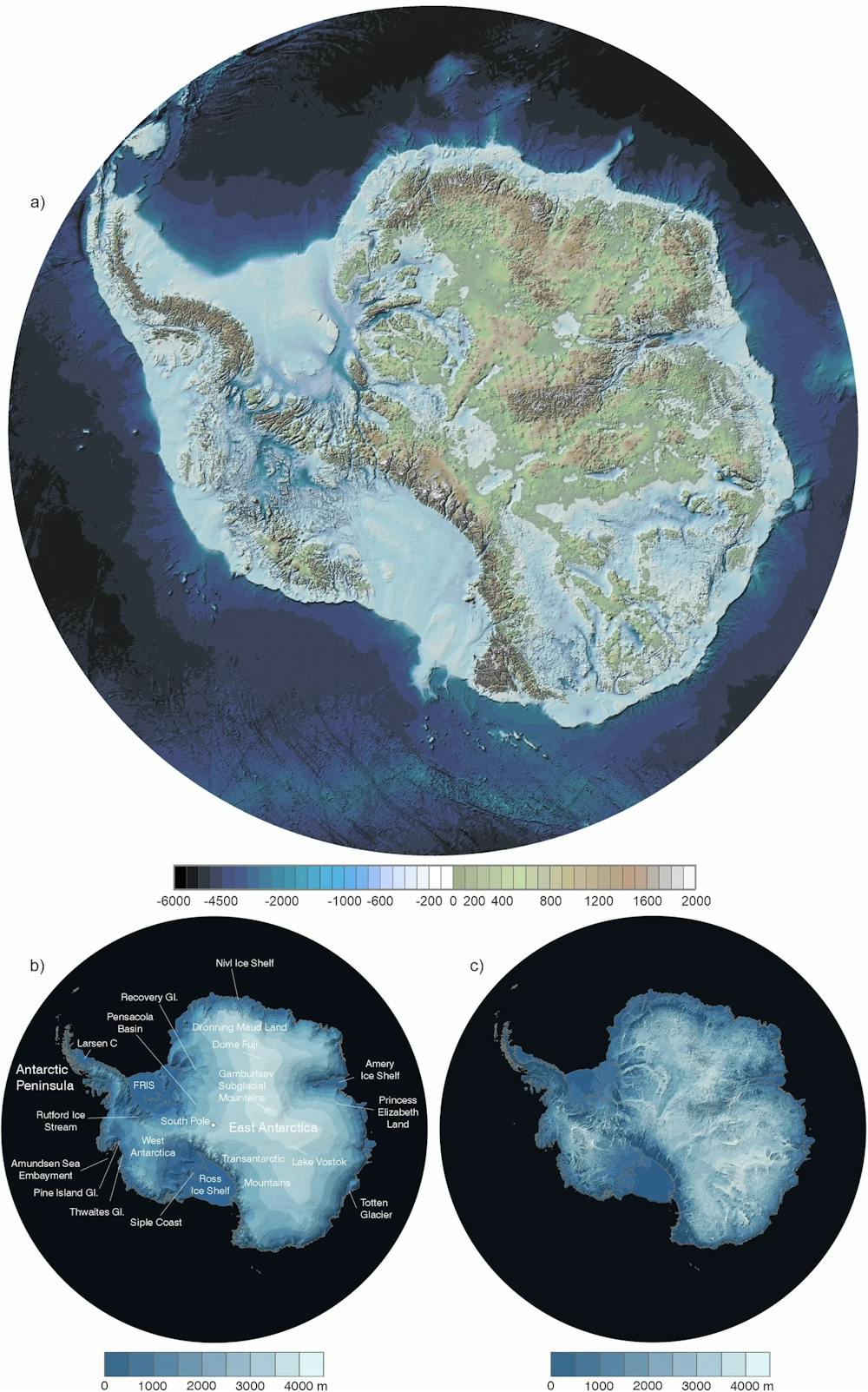
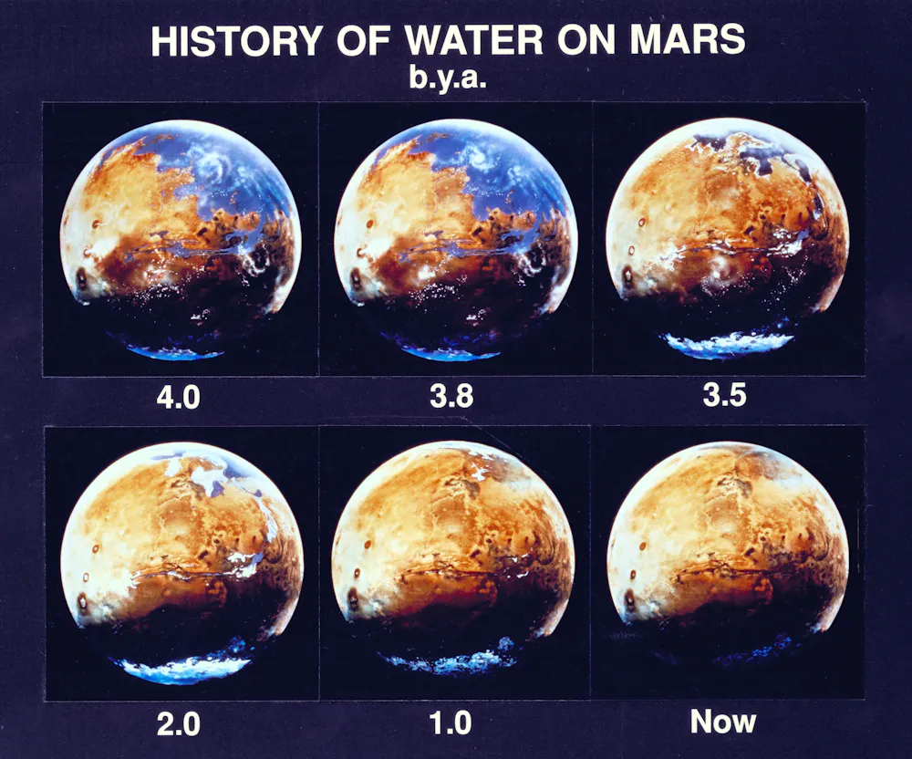
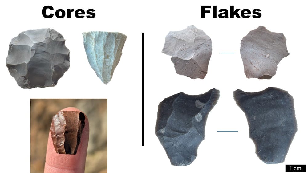