Category: Natural Disasters

  • MIL-OSI USA: NASA Supports Wildland Fire Technology Demonstration

    Source: NASA

    Advancements in NASA’s airborne technology have made it possible to gather localized wind data and assess its impacts on smoke and fire behavior. This information could improve wildland fire decision making and enable operational agencies to better allocate firefighters and resources. A small team from NASA’s Armstrong Flight Research Center in Edwards, California, is demonstrating how some of these technologies work.
    Two instruments from NASA’s Langley Research Center in Hampton, Virginia – a sensor gathering 3D wind data and a radiosonde that measures temperature, barometric pressure, and humidity data – were installed on NASA Armstrong’s Alta X drone for a prescribed burn in Geneva State Forest, which is about 100 miles south of Montgomery, Alabama. The effort is part of the agency’s multi-year FireSense project, which is aimed at testing technologies that could eventually serve the U.S. Forest Service as well as local, state, and other federal wildland fire agencies.
    “The objectives for the Alta X portion of the multi-agency prescribed burn include a technical demonstration for wildland fire practitioners, and data collection at various altitudes for the Alabama Forestry Commission operations,” said Jennifer Fowler, FireSense project manager. “Information gathered at the different altitudes is essential to monitor the variables for a prescribed burn.”
    Those variables include the mixing height, which is the extent or depth to which smoke will be dispersed, a metric Fowler said is difficult to predict. Humidity must also be above 30% for a prescribed burn. The technology to collect these measurements locally is not readily available in wildland fire operations, making the Alta X and its instruments key in the demonstration of prescribed burn technology.

    In addition to the Alta X flights beginning March 25, NASA Armstrong’s B200 King Air will fly over actively burning fires at an altitude of about 6,500 feet. Sensors onboard other aircraft supporting the mission will fly at lower altitudes during the fire, and at higher altitudes before and after the fire for required data collection. The multi-agency mission will provide data to confirm and adjust the prescribed burn forecast model.
    Small, uncrewed aircraft system pilots from NASA Armstrong completed final preparations to travel to Alabama and set up for the research flights. The team – including Derek Abramson, chief engineer for the subscale flight research laboratory; Justin Hall, NASA Armstrong chief pilot of small, uncrewed aircraft systems; and Alexander Jaffe, a drone pilot – will set up, fly, observe airborne operations, all while keeping additional aircraft batteries charged. The launch and recovery of the Alta X is manual, the mission profile is flown autonomously to guarantee the same conditions for data collection.
    “The flight profile is vertical – straight up and straight back down from the surface to about 3,000 feet altitude,” Abramson said. “We will characterize the mixing height and changes in moisture, mapping out how they both change throughout the day in connection with the burn.”
    In August 2024, a team of NASA researchers used the NASA Langley Alta X and weather instruments in Missoula, Montana, for a FireSense project drone technology demonstration. These instruments were used to generate localized forecasting that provides precise and sustainable meteorological data to predict fire behavior and smoke impacts.

    MIL OSI USA News

  • MIL-OSI USA: Governor Newsom announces appointments 4.3.25

    Source: US State of California 2

    Apr 3, 2025

    SACRAMENTO – Governor Gavin Newsom today announced the following appointments:

    Trista H. Woessner-Gonzalez, of Granite Bay, has been appointed Director of the California Department of Tax and Fee Administration, where she has served in several roles including as Chief Deputy Director since 2021 and as Chief of the Tax Policy Bureau from 2016 to 2021. Woessner-Gonzalez held several positions at the California State Board of Equalization from 1992 to 2016, including CROS Business Project Manager, Procurement Manager, Audit and Information Section Supervisor, Tax Policy Division Technical Advisor, Audit Support Unit Supervisor, Audit Support Specialist, Audit Reviewer, and Sales and Use Tax Auditor. She earned a Bachelor of Science degree in Business Administration from California State University, Chico. This position requires Senate confirmation, and the compensation is $160,428. Woessner-Gonzalez is a Democrat. 

    James Hacker, of Sacramento, has been appointed Undersecretary of the California State Transportation Agency. Hacker has been a Deputy Cabinet Secretary in the Office of Governor Newsom since 2023. He was a Principal Consultant at the California State Senate Budget Committee from 2017 to 2023. Hacker was a Finance Budget Analyst at the California Department of Finance from 2015 to 2017. He was a Fiscal and Policy Analyst in the California Legislative Analyst’s Office from 2014 to 2015. He was a Consultant at Deloitte from 2009 to 2013. Hacker earned a Master of Public Administration degree in Energy and Environmental Policy from Syracuse University, and a Bachelor of Arts degree in International Affairs and Economics from George Washington University. This position does not require Senate confirmation, and the compensation is $218,388. Hacker is a Democrat.

    Emily Desai, of Sacramento, has been appointed Chief Deputy Director at the Governor’s Office of Business and Economic Development. Desai has been Senior Deputy Director for Strategic Program Planning and External Affairs at the Governor’s Office of Business and Economic Development since 2024, where she has held several roles since 2019, including Deputy Director of International Affairs and Trade, Trade and Investment Representative for Europe, Middle East, and India, and Special Advisor of International Affairs and Investment. She was Senior Project Manager of International Affairs and Trade for the Government Accountability Office from 2014 to 2019. Desai was a Senior Policy Analyst for the Pacific Institute and the United Nations Global Compact CEO Water Mandate in 2014. She was a Senior Associate at the Nonprofit Finance Fund from 2010 to 2012. Desai is a Presidential Leadership Scholar, Vice President of the Board of Directors of the State International Development Organization, and a member of the United States Investment Advisory Council and the United States Intergovernmental Policy Advisory Committee on International Trade. She earned a Master of Public Policy degree from the University of California, Berkeley, and a Bachelor of Science degree in Public Administration and International Business from the University of Arizona. This position does not require Senate confirmation, and the compensation is $190,536. Desai is a Democrat.

    Trisha Smith, of Antelope, has been appointed Deputy Secretary of Administrative Services at the California Department of Veterans Affairs, where she has held multiple positions since 2015 including Assistant Deputy Secretary, Human Resources, Assistant Human Resources Director, and Staff Services Manager II. Smith held multiple roles at the California Department of Human Resources from 2009 to 2015, including Personnel Officer and Personnel Program Analyst. She held multiple positions at California Highway Patrol from 1994 to 2009, including Associate Personnel Analyst, Staff Services Analyst, Personnel Supervisor, Personnel Specialist and Office Assistant. This position does not require Senate confirmation, and the compensation is $160,048. Smith is a Democrat.

    David Wesley, of San Diego, has been appointed Deputy Chief of Enforcement at the Division of Occupational Safety and Health at the Department of Industrial Relations. Wesley has been Assistant Deputy Chief at the Division of Occupational Safety and Health at the Department of Industrial Relations since 2022, where he has held several roles since 2017, including Senior Safety Engineer and Associate Safety Engineer. He was the Radiation Safety Officer at the University of Southern California from 2007 to 2017. Wesley was the Radiation Safety Officer at University of California, Riverside from 2004 to 2007. He held several roles at the California Department of Health Services from 1993 to 2003, including Chef of Radioactive Materials Licensing, Chief of the Licensing Projects Unit, and Associate Health Physicist. Wesley held multiple roles in the United States Air Force from 1987 to 1992, including Chief of Nuclear Quality Assurance and Aircraft Nuclear Safety Engineer. He earned a Master of Science degree in Nuclear Engineering from the Air Force Institute of Technology and a Bachelor of Science degree in Nuclear Engineering from the Georgia Institute of Technology. This position does not require Senate confirmation, and the compensation is $192,108. Wesley is a Republican.

    Press Releases, Recent News

    Recent news

    News SACRAMENTO – Ahead of a series of severe storms set to impact Kentucky, Governor Gavin Newsom today announced the deployment of California firefighters to assist in staffing a Federal Emergency Management Agency (FEMA) Incident Support Team, following FEMA’s…

    News What you need to know: The Governor’s Wildfire and Forest Resilience Task Force released a list of 25 key deliverables to build on the state’s ongoing efforts to protect Californians from increasing threats posed by catastrophic wildfire and a changing climate….

    News What you need to know: Since March 2024, Governor Newsom’s joint Bay Area operation efforts have yielded 3,217 stolen vehicles recovered, 1,823 suspects arrested, and 170 illicit firearms seized. Sacramento, California – Continuing to provide collaborative public…

    MIL OSI USA News

  • MIL-OSI USA: At FEMA’s request, California deploys firefighters to Kentucky ahead of severe storms

    Source: US State of California 2

    Apr 3, 2025

    SACRAMENTO – Ahead of a series of severe storms set to impact Kentucky, Governor Gavin Newsom today announced the deployment of California firefighters to assist in staffing a Federal Emergency Management Agency (FEMA) Incident Support Team, following FEMA’s request for support.

    Kentucky Governor Andy Beshear declared a state of emergency due to severe storms forecasted to generate heavy rain and damaging winds that can potentially lead to tornadoes, hail, and flooding.

    In close coordination with FEMA, the California Governor’s Office of Emergency Services (Cal OES) is deploying four specially-trained firefighters from California’s Urban Search and Rescue (US&R) Task Force Incident Support Team. The deployment has no impact on California’s emergency response and firefighting capabilities.

    “California understands the threat extreme weather poses and stands with Kentucky ahead of the storms set to impact their state. These deployed resources will provide additional support to first responders across Kentucky to prepare and respond to storms.”

    Governor Gavin Newsom

    The Incident Support Team provides a group of highly qualified specialists to support local first responders with technical assistance, management and coordination of US&R resources.

    “As Kentucky prepares for a series of dangerous storms, we’re proud to send California-based firefighters with expertise in responding to this type of weather,” said Cal OES Director Nancy Ward. “Their experience will help bolster response efforts.”

    The specialized team members deployed to Kentucky come from California US&R Task Forces 4, 5 and 8 from Oakland, Orange County and San Diego.

    This deployment builds on California’s continued efforts to aid other state during emergencies. In February, California deployed resources to Kentucky in response to extreme flooding. Last year, Governor Newsom deployed a similar Incident Support Team to Florida to bolster response to Hurricanes Helene and Milton.

    Press Releases, Recent News

    Recent news

    News What you need to know: The Governor’s Wildfire and Forest Resilience Task Force released a list of 25 key deliverables to build on the state’s ongoing efforts to protect Californians from increasing threats posed by catastrophic wildfire and a changing climate….

    News What you need to know: Since March 2024, Governor Newsom’s joint Bay Area operation efforts have yielded 3,217 stolen vehicles recovered, 1,823 suspects arrested, and 170 illicit firearms seized. Sacramento, California – Continuing to provide collaborative public…

    News SACRAMENTO – Governor Gavin Newsom today announced that he has signed the following bill:SB 26 by Senator Thomas Umberg (D-Santa Ana) – Civil actions: restitution for or replacement of a new motor vehicle. A signing message can be found here.For full text of the…

    MIL OSI USA News

  • MIL-OSI Africa: Nelson Mandela Bay Municipality announces new appointments

    Source: South Africa News Agency

    Nelson Mandela Bay Municipality Executive Mayor, Babalwa Lobishe, has commended the appointment of two senior managers who have been placed in acting roles for the next six months.

    “We welcome these appointments. We will hit the ground running to fast-track service delivery issues, prioritise the flood related infrastructure interventions in Kariega and other affected areas,” Lobishe said of the appointments in the Eastern Cape based municipality.

    This as on Tuesday, the MEC for Cooperative Governance and Traditional Affairs (COGTA), Zolile Williams confirmed the appointment of Ted Pillay as the Acting City Manager and Lonwabo Ngoqo as the acting Chief Operating Officer (COO).

    These appointments materialise following a request by the Nelson Mandela Bay Municipality Council and the Executive Mayor, for a section 154 intervention through COGTA and the MEC by appointing an Acting City Manager and a COO.

    The appointments come after a request from the municipality’s council and Executive Mayor for a Section 154 intervention through COGTA, aimed at strengthening the municipality’s administrative and governance capacity.

    Section 154 of the South African Constitution requires the national and provincial governments to support and strengthen the capacity of municipalities to perform their functions.

    Speaking at a recent press conference, Lobishe said the appointments come at a time when the municipality is working around the clock to accelerate service delivery.

    “We thank MEC Williams for the interventions to address service delivery challenges. We are looking forward to work with this team of experienced senior officials,” Lobishe said.

    On the status of the current City Manager, Mayor Lobishe confirmed that negotiations are ongoing with Dr. Noxolo Nqwazi, who is currently on suspension, regarding the terms of her contract termination.

    The municipality aims to the resolve the matter with the incumbent City Manager over the next six months.

    The MEC said the interventions are based on the request that the Council has made for the specific appointments.

    The acting appointments took effect from 1 April 2025.
    SAnews.gov.za
     

    MIL OSI Africa

  • MIL-OSI Africa: KwaZulu-Natal police operations bear fruit

    Source: South Africa News Agency

    Friday, April 4, 2025

    Police in KwaZulu-Natal have arrested 11 780 suspects for various crimes while also recovering 341 firearms and 3 562 rounds of ammunition.

    “The highest number of arrests was for contact crimes where 3 872 suspects were nabbed, with 219 of them arrested for murder, 222 for attempted murder and 160 for robberies including robbery with aggravating circumstances, house and business robbery, carjacking and cash in transit robbery,” the South African Police Service (SAPS) said of the arrests made in March.

    In its statement on Thursday, the SAPS said the Family Violence, Child Protection and Sexual Offences Unit (FCS) detectives arrested 248 suspects for rape while 49 suspects were also arrested for sexual assault.

    Additionally, 1 817 suspects were arrested for cases of assault with intent to inflict grievous bodily harm, whilst 891 more suspects were nabbed for common assault. On property related crimes, 268 suspects were arrested for burglary at residential premises and 55 suspects were arrested for stock theft with 33 cattle and 80 goats recovered in the process. 

    Seventeen suspects were also arrested for theft of motor vehicles.

    On drug related crimes, 1 599 suspects were arrested. 

    “Police visibility on the roads was maintained and 512 suspects were arrested for driving under the influence of alcohol or drugs, and 41 people were arrested for reckless and negligent driving.

    “Stop and search operations resulted in the recovery of 791dangerous weapons, of which 716 were knives. These operations will be amplified during the month of April and high police visibility will be maintained, especially during the Easter weekend,” said the police. –SAnews.gov.za

    MIL OSI Africa

  • MIL-OSI United Nations: Global experts meet in Sendai, Japan, to bridge knowledge and technology gaps in disaster risk reduction

    Source: UNISDR Disaster Risk Reduction

    Experts from around the world met in Sendai, Japan, on 8 March 2025 to explore how emerging and disruptive technologies can reshape disaster risk reduction (DRR) and resilience-building, particularly in the Global South. 

    The ‘Leveraging Emerging and Disruptive Technologies for Disaster Risk Reduction (DRR): Bridging Science, Technology, Academia, and Private Sector Nexus’ workshop, on the sidelines of the World Bosai Forum, brought together national and local governments, academia, the private sector, and financial institutions to overcome barriers and identify opportunities in integrating innovations such as AI, satellite systems, IoT, blockchain, and advanced analytics into DRR strategies. 

    The workshop emerged from to the Sendai Framework’s midterm review, which called on the DRR community to address persistent gaps in applying scientific and technological advances in disaster resilience efforts. 

    As disasters grow more complex, there’s a pressing need to ensure that countries, especially those most vulnerable, can access and use emerging technologies effectively, Sujit Mohanty, Chief of Intergovernmental, Interagency Cooperation and Partnerships at UNDRR, remarked during his opening remarks. 

    Mr Mohanty emphasised that while new tools are being rapidly developed, countries face challenges related to affordability, infrastructure, expertise, and cross-sector collaboration. Overreliance on untested technologies, he warned, may introduce new risks if not managed with care. 

    Real-world barriers and solutions 

    A highlight of the event was the roundtable discussion featuring speakers from Bangladesh, the Philippines, Mexico City, Sendai City, Japan’s private sector and academia. 

    Bangladesh’s representative, Mr Mohammad Nazmul Abedin, noted how the country has drastically reduced disaster-related deaths—from over 100,000 in 1991 to near zero in 2024—yet struggles to scale satellite-based flood monitoring and data-sharing mechanisms. He said the Bangladesh needs a national technology policy that integrates AI and blockchain, along with more investment and public-private partnerships. 

    Echoing similar constraints, Assistant Secretary Bernardo Rafaelito R. Alejandro IV of the Philippines outlined his country’s efforts, such as the GeoRisk platform and IoT-enabled early warning systems. Technology is part of the solution, but it must be paired with good governance, inclusive policies and international collaboration, he noted. 

    Sendai City showcased successful collaboration through initiatives like BOSAI-TECH—a public-private-academic platform fostering DRR innovation and technology commercialisation. Ms. Satoko Shibuya, Director at Sendai’s Disaster-Resilient and Environmentally Friendly City Promotion Office, explained that local partnerships have yielded practical tools like evacuation guidance drones and voice-enhanced disaster alerts. 

    Financing innovation and building trust 

    Speakers representing private sector participants discussed the financial and regulatory environments needed to bring DRR technologies to scale. Mr. Yoshiki Hiruma of the Development Bank of Japan shared insights into DRR-linked financing that rewards clients with reduced loan rates for resilience-building initiatives. He noted that risk financing must embrace a challenge mindset to support DRR innovation. 

    Mr. Shoichi Tateno, of Weathernews Inc., stressed the importance of mutual understanding and trust between governments and private weather service providers – particularly in countries where state meteorological services dominate the sector. He offered the inclusive platform approach of Japan’s Meteorological Service Act as a model of such trust. 

    Academia can offer reliable innovation and policy integration 

    Participants from academia stressed the need for adaptive governance and robust dialogue.  

    Professor Rajib Shaw of Keio University called for more systematic evaluation of successful DRR tech collaborations and piloting through initiatives like the upcoming Association of Pacific Rim Universities (APRU) DRR Innovation Hub. He pointed out that governments and technology developers operate at different speeds, and that it requires structure, trust, and experimentation in order to bridge that divide. 

    Professor Kimio Takeya of the Japan International Cooperation Agency (JICA) and Tohoku University said that while proven technologies remain essential for national governments, they must be extended with emerging tools that offer new ways to improve operations. He cited JICA’s Science and Technology Research Partnership for Sustainable Development (SATREPS) programme – which funds international research on disaster risk reduction – as a model for innovation grounded in collaboration. 

    A global partnership and a dedicated knowledge resource 

    In closing, Mr Mohanty said that UNDRR will facilitate Global Partnership on Emerging and Disruptive Technologies for Disaster Resilience which will foster long-term collaboration and ensure that the next wave of DRR innovation is inclusive, actionable, and globally accessible. 

    He remarked that the workshop had spotlighted the urgent need for a dedicated knowledge resource – one that captures good practices and deepens understanding of how emerging technologies are shaping the current DRR landscape.  

    Such a tool could bridge persistent gaps and drive more effective, widespread integration of innovation into disaster risk reduction efforts. 

    Read the full summary report on the workshop

    MIL OSI United Nations News

  • MIL-OSI Video: Israel/Palestine: Human Rights Situation- Security Council Briefing | United Nations

    Source: United Nations (Video News)

    Briefing by Volker Türk, United Nations High Commissioner for Human Rights, on the situation in the Middle East, including the Palestinian question.
    ———
    UN human rights chief Volker Türk called for “an independent, prompt and thorough investigation” into the killings of 15 medical personnel and humanitarian aid workers in Gaza, stating that “those responsible for any violation of international law must be held to account.”

    High Commissioner for Human Rights Volker Türk today (03 Apr) told Council members that he is “appalled” by the recent killings of 15 medical personnel and humanitarian aid workers, “which raise further concerns over the commission of war crimes by the Israeli military.”

    Türk said, “The Israeli military continues to strike camps for people who have been displaced numerous times, who have nowhere safe to go. The Israeli military also continues to force civilians to move.”

    “Half of Gaza is now under mandatory evacuation orders or has been declared a no-go zone,” the UN human rights chief added.

    He reiterated, “these orders fail to comply with the requirements of international humanitarian law.

    Türk also highlighted, “Hamas and other Palestinian armed groups continue to launch indiscriminate rockets from Gaza into Israel, in breach of international humanitarian law.”

    He said, “I am also deeply concerned about the fate and wellbeing of Israeli hostages still held in Gaza.”

    The High Commissioner is also “alarmed by the inflammatory rhetoric by senior Israeli officials around seizing, annexing and dividing territory, and about transferring Palestinians outside Gaza.”

    “This raises grave concerns about the commission of international crimes and runs counter to the fundamental principle of international law against the acquisition of territory by force,” he added.

    Türk highlighted, “in Resolution 2735 passed last June, this Council rejected any attempt at demographic or territorial change in the Gaza Strip, including any actions that reduce the territory of Gaza.”

    The High Commissioner urged “the immediate restoration of the ceasefire and unimpeded humanitarian access throughout Gaza.”

    He warned again that “there is a high and increasing risk that atrocity crimes are being committed in the Occupied Palestinian Territory.”

    The human rights chief stressed, “Under the Geneva Conventions, States have an obligation to act when a serious violation of international humanitarian law has been committed.”

    Under the Convention on the Prevention and Punishment of the Crime of Genocide, he continued, “State parties have the responsibility to act to prevent such a crime, when risk becomes apparent.”

    Türk urged all those with influence to “ensure the protection of civilians as a matter of absolute priority,” adding that “it is essential that there is full accountability for all violations of international humanitarian and human rights law.”

    “All hostages must be released immediately and unconditionally. All those arbitrarily detained must also be released. Israel must refrain from any acts amounting to forcible transfer of Gaza’s population,” he concluded.

    https://www.youtube.com/watch?v=ObmrwI50hf4

    MIL OSI Video

  • MIL-OSI United Nations: Secretary-General’s video message at the Central Asia in the Face of Global Climate Challenges; Consolidation for Common Prosperity International Conference

    Source: United Nations secretary general

    Download the video:
    https://s3.us-east-1.amazonaws.com/downloads2.unmultimedia.org/public/video/evergreen/MSG+SG+/SG+3+April+25/3357789_MSG+SG+COMMON+PROSPERITY+INTL+CONFERENCE+03+APR+25.mp4

    Excellencies.

    Thank you for your invitation.

    I commend President Mirziyoyev for hosting this conference — and for declaring 2025 the year of environmental protection and the green economy. 

    I also applaud the environment of dialogue and cooperation that characterises the region today.

    This approach is reflected in the recent summit between Kyrgyzstan, Tajikistan and Uzbekistan, and their trilateral agreement on the Junction Point of State borders.

    And it is reflected in this International Conference today.

    Excellencies,

    The climate crisis is taking hold around the world. 

    The evidence is all around us – with the hottest days, the hottest months, the hottest years, and the hottest decade on record. 

    We see it clearly in Central Asia with soaring temperatures, glacier retreat, droughts, and worsening dust storms.

    Left unchecked, this crisis will only escalate – pummelling economies, taking lives, devastating livelihoods, and imperilling food and water supplies.

    The tragedy of the Aral Sea also shows how environmental destruction hurts people and communities.

    Cooperation throughout Central Asia is essential.

    And regional action must be complemented by global action.

    New national climate plans – or NDCs – due this year must align with limiting global temperature rise to 1.5 degrees Celsius, as promised.

    And cover all emissions and the whole economy.

    The G20 must lead. 

    This is an opportunity to bring together energy transition strategies and sustainable development priorities with climate action – to attract investment and build prosperity and security.

    I urge all countries to take it.

    And to act to ensure the world makes good on climate finance commitments.

    We need confidence the new $1.3 trillion climate finance goal will be delivered.
     
    We need developed countries to honour the promise of at least $40 billion a year for adaptation, by this year.

    And we must strengthen support for loss and damage to help the most vulnerable countries and people.

    Excellencies,

    Once again, thank you for coming together to forge a path forward – and deliver.

    I wish you a successful conference.

    Thank you.
     

    MIL OSI United Nations News

  • MIL-Evening Report: NZ’s refreshingly candid ex-envoy Phil Goff – why I spoke out on Trump

    Now that Phil Goff has ended his term as New Zealand’s High Commissioner to the UK, he is officially free to speak his mind on the damage he believes the Trump Administration is doing to the world. He has started with these comments he made on the betrayal of Ukraine by the new Administration.

    By Phil Goff

    Like many others, I was appalled and astounded by the dishonest comments made about the situation in Ukraine by the Trump Administration.

    As one untruthful statement followed another like something out of a George Orwell novel, I increasingly felt that the lies needed to be called out.

    I found it bizarre to hear President Trump publicly label Ukraine’s leader Volodymyr Zelenskyy a dictator. Everyone knew that Zelenskyy had been democratically elected and while Trump claimed his support in the polls had fallen to 4 percent it was pointed out that his actual support was around 57 percent.

    Phil Goff speaking as Auckland’s mayor in 2017 on the nuclear world 30 years on . . . on the right side of history. Image: Pacific Media Centre

    Trump made no similar remarks or criticism of Russia’s Vladimir Putin and never does. Yet Putin’s regime imprisons and murders his opponents and suppresses democratic rights in Russia.

    Then Trump made the patently false accusation that Ukraine started the war with Russia. How could he make such a claim when the world had witnessed Russia as the aggressor which invaded its smaller neighbour, killing thousands of civilians, committing war crimes and destroying cities and infrastructure?

    That President Trump could lie so blatantly is perhaps explained by his taking offence at Zelenskyy’s refusal to comply with unreasonable and self-serving demands such as ceding control of Ukraine’s mineral wealth to the US. What was also clear was that Trump was intent on pressuring Ukraine to capitulate to Russian demands for a one sided “peace settlement” which would result in neither a fair nor sustainable peace.

    It is astonishing that the US voted with Russia and North Korea in the United Nations against Ukraine and in opposition to the views of democratic countries the US is normally aligned with, including New Zealand.

    Withdrew satellite imaging
    It then withdrew satellite imaging services Ukraine needed for its self defence in an attempt to further pressure Zelenskyy to agree to a ceasefire. No equivalent pressure has yet been placed on Russia even while it has continued its illegal attacks on Ukraine.

    Trump and Vance’s disgraceful bullying of Zelenskyy in the White House as he struggled in his third language to explain the plight of his nation was as remarkable as it was appalling.
    What Trump was doing and saying was wrong and a betrayal of Ukraine’s struggle to defend its freedom and nationhood.

    Democratic leaders around the world knew his comments to be unfair and untrue, yet few countries have dared to criticise Trump for making them.

    Like the Hans Christian Anderson fairy tale, everyone knew that the emperor had no clothes but were fearful of the consequences of speaking out to tell the truth.

    As New Zealand’s High Commissioner to the UK, I had on a number of occasions met and talked with Ukrainian soldiers being trained by New Zealanders in Britain. It was an emotionally intense experience knowing that many of the men I met with would soon face death on the front line defending their country’s freedom and nationhood.

    They were extremely grateful of New Zealand’s unwavering support. Yet the Trump Administration seemed to care little for that country’s cause and sacrifice in defending the values that a few months earlier had seemed so important to the United States.

    The diplomatic community in London privately shared their dismay at Trump’s treatment of Ukraine. The spouse of one of my High Commissioner colleagues who had been a teacher drew a parallel with what she had witnessed in the playground. The bully would abuse a victim while all the other kids looked on and were too intimidated to intervene. The majority thus became the enablers of the bully’s actions.

    Silence condoning Trump
    By saying nothing, New Zealand — and many other countries — was effectively condoning and being complicit in what Trump was doing.

    It was in this context, at the Chatham House meeting, that I asked a serious and important question about whether President Trump understood the lessons of history. It was a question on the minds of many. I framed it using language that was reasonable.

    The lesson of history, going back to the Munich Conference in 1938, when British Prime Minister Chamberlain and his French counterpart Daladier ceded the Sudetenland part of Czechoslovakia to Hitler, was clear.

    Far from satisfying or placating an aggressor, appeasement only increases their demands. That’s always the case with bullies. They respect strength, not weakness.

    Czechoslovakia could have been part of the Allied defence against Hitler’s expansionism but instead it and the Czech armaments industry was passed over to Hitler. He went on to take over the rest of Czechoslovakia and then invaded Poland.

    As Churchill told Chamberlain, “You had the choice between dishonour and war. You chose dishonour and you will have war.”

    The question needed to be asked because Trump was using talking points which followed closely those used by the Kremlin itself and was clearly setting out to appease and favour Russia.

    A career diplomat, trained as a public servant to be cautious, might have not have asked it. I was appointed, with bipartisan support, not as a career diplomat but on the basis of political experience including nine years as Foreign, Trade and Defence Minister.

    Question central to validity, ethics
    “The question is central to the validity as well as the ethics of the United States’ approach to Ukraine. It is also a question that trusted allies, who have made sacrifices for and with each other over the past century, have a right and duty to ask.

    The New Zealand Foreign Minister’s response was that the question did not reflect the view of New Zealand’s Government and that asking it made my position as High Commissioner untenable.

    The minister had the prerogative to take the action he did and I am not complaining about that for one moment. For my part, I do not regret asking the question which thanks to the minister’s response subsequently received international attention.

    Over the decades New Zealand has earned the respect of the world, from allies and opponents alike, for honestly standing up for the values our country holds dear. The things we are proudest of as a nation in the positions we have taken internationally include our role as one of the founding states of the United Nations in promoting a rules-based international system including our opposition to powerful states exercising a veto.

    They include opposing apartheid in South Africa and French nuclear testing in the Pacific. We did not abandon our nuclear free policy to US pressure.

    In wars and in peacekeeping we have been there when it counted and have made sacrifices disproportionate to our size.

    We have never been afraid to challenge aggressors or to ask questions of our allies. In asking a question about President Trump’s position on Ukraine I am content that my actions will be on the right side of history.

    Phil Goff, CNZM, is a New Zealand retired politician and former diplomat. He served as leader of the Labour Party and leader of the Opposition between 11 November 2008 and 13 December 2011. Goff was elected mayor of Auckland in 2016, and served two terms, before retiring in 2022. In 2023, he took up a diplomatic post as High Commissioner of New Zealand to the United Kingdom, which he held until last month when he was sacked by Foreign Minister Winston Peters over his “untenable” comments.

    MIL OSI AnalysisEveningReport.nz

  • MIL-OSI Economics: A journey into forgotten Null Session and MS-RPC interfaces, part 2

    Source: Securelist – Kaspersky

    Headline: A journey into forgotten Null Session and MS-RPC interfaces, part 2

    In the first part of our research, I demonstrated how we revived the concept of no authentication (null session) after many years. This involved enumerating domain information, such as users, without authentication. I walked you through the entire process, starting with the difference between no-auth in the MS-RPC interfaces and the well-known null session, and ending with the methodology used to achieve our goal.

    Today, as promised, we’ll dive into part two. Here, we’ll explore why Windows behaves the way it does – allowing domain information to be enumerated without authentication. I’ll also explain why this activity is difficult to prevent and monitor.

    First, we’ll examine why this activity is hard to stop by looking at how WMI works. We’ll also discuss the methods available for detecting and addressing this issue.

    After that, we’ll cover some basics about MS-RPC security and how to secure your RPC server. Then we’ll analyze the security of the MS-NRPC interface using two approaches: theoretical insight and reverse engineering to gain a deeper understanding.

    So, buckle up and let’s continue our journey!

    The group policy that punches your domain in the face

    When it comes to stopping certain activities in Windows, group policies are often the first line of defense, and our case is no exception. As we discussed in part one, the Restrict Unauthenticated RPC Clients policy can be used to block no-auth activity against interfaces. This policy comes with three settings: “None”, “Authenticated”, and “Authenticated without exceptions”.

    While testing, we discovered that even with the policy set to “Authenticated”, it’s still possible to enumerate domain information using MS-NRPC and network interfaces using the IObjectExporter interface. Naturally, the next logical step would be to use the “Authenticated without exceptions” setting to completely block such activity.

    At first, enabling “Authenticated without exceptions” seems to work perfectly – blocking all enumeration activity with no authentication. Over time, however, we would notice significant issues: many of the domain controller’s functions would stop working. This is not surprising, as Microsoft has explicitly warned that using this policy setting can severely disrupt domain controller functionality. In fact, it has been described as “the group policy that punches your domain in the face,” effectively rendering the domain controller inoperable.

    To better understand this issue, let’s use WMI as an example and examine why setting this policy to “Authenticated without exceptions” causes domain functionality to fail.

    WMI as DCOM object

    Windows Management Instrumentation (WMI) is the infrastructure for managing data and operations on Windows-based operating systems. It’s widely used by system administrators for everyday tasks, including remote management of Windows machines.

    To test the effect of setting the Restrict Unauthenticated RPC Clients policy to “Authenticated without exceptions”, let’s try to access WMI on a remote machine using the wmic command to list processes. In this case, we’ll use valid administrator credentials for the remote machine.

    Listing remote processes using wmic

    As shown in the screenshot above, the attempt to list remote processes fails with an “Access Denied” error, even with valid administrator credentials. But why does this happen?

    Remote WMI access relies on the DCOM architecture. To interact with the WMI server, a DCOM object must first be created on the remote machine. As explained in part one, interfaces such as IObjectExporter ( IOXIDResolver) are responsible for locating and connecting to DCOM objects.

    In simpler terms native Windows libraries typically use the IObjectExporter interface by default during the initial steps of creating a DCOM object, although it is technically optional. When binding the interface, the authentication level is set to “no authentication” (level 1). Next, the libraries use the ServerAlive2 function.

    When the Restrict Unauthenticated RPC Clients policy is set to “Authenticated without exceptions”, it blocks these no-auth activities. This prevents the creation of DCOM objects, so the WMIC command that creates a DCOM object fails and returns an “Access Denied” error, even if the credentials are valid.

    Furthermore, since DCOM object creation is integral to many domain controller functions, blocking these activities can disrupt most operations on the domain controller. In short, setting the policy to “Authenticated without exceptions” not only breaks remote WMI access, it also impacts broader domain functionality.

    To better understand this behavior, let’s examine what happens under the hood when we set the Restrict Unauthenticated RPC Clients policy to “Authenticated” or “None”. Using Wireshark, we’ll capture the traffic while running the same PowerShell command as before.

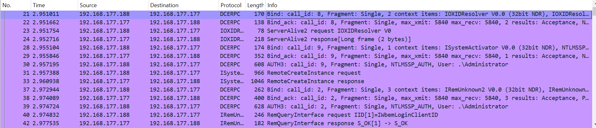
    Network traffic for remote WMI

    In the captured traffic, we can see that before the DCOM object is created, the IOXIDResolver interface must be bound, and the ServerAlive2 function is called (packets 21-24).

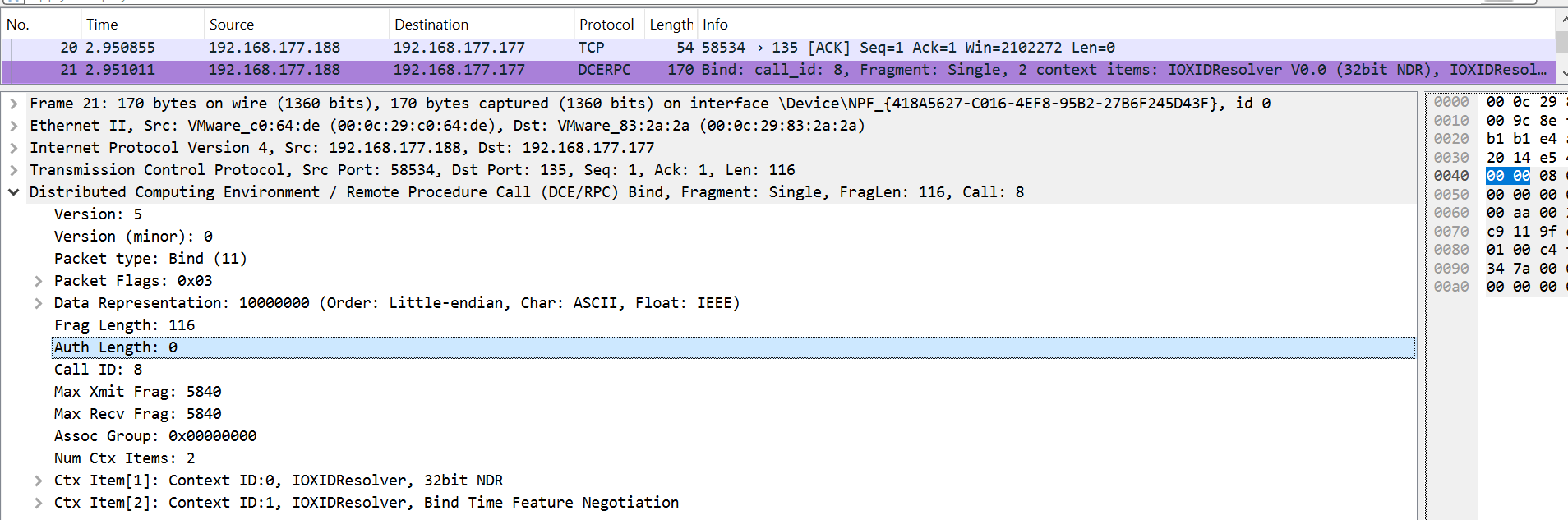
    If we inspect packet 21, which contains the bind request, we see that the native libraries bind the interface without authentication – because the authentication length is zero.

    Binding without authentication

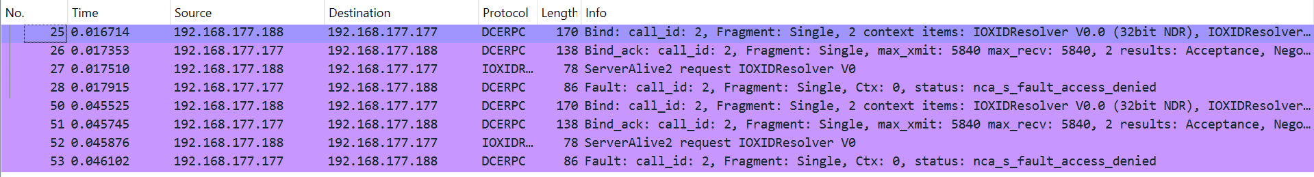
    Next, let’s inspect the traffic when the Restrict Unauthenticated RPC Clients policy is set to “Authenticated without exceptions”.

    Network traffic for WMI

    From the captured traffic, we can see several “Access Denied” responses when attempting to call the ServerAlive2 function with valid credentials. This happens because the policy blocks the no-authentication behavior, effectively stopping the initial binding of the IOXIDResolver interface (which binds without authentication by default). The failure to bind the interface at the beginning of the process is what causes this error, proving that it does not come from WMI itself.

    The event that never occurs

    As we saw earlier, preventing enumeration of domain information seems impossible, but detecting it might be another story. The first place to look for detection is Windows audit policies. I found the audit policy under event ID 5712, which should generate an event like “Audit RPC Events 5712(S): A Remote Procedure Call (RPC) was attempted.”

    However, Microsoft states that this event never occurs, and after enabling this audit policy, I indeed found no related events in the event viewer for any RPC attempts.

    The event that never occurs seemed like a dead end for detecting RPC activity. However, after further research, I found two additional ways to detect RPC activity.

    The first method is Event Tracing for Windows, which logs RPC-related events. However, it lacks useful details such as the IP address of the RPC client and generates many events, including local RPC activity, making it difficult to parse.

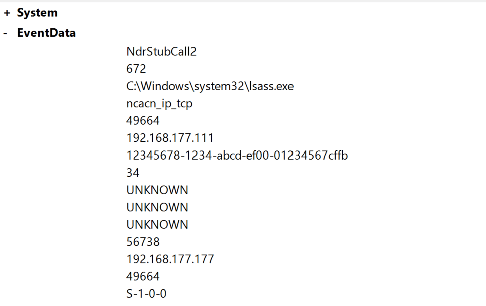
    The second method is to use third-party open source software called RPC-Firewall. This tool audits all remote RPC calls, allowing you to track RPC UUIDs and opnums, block specific ones, and filter by source address. It integrates with the event viewer to display logs, as shown in the screenshot below of an RPC event generated by RPC-Firewall.

    RPC-Firewall RPC event

    Prior to conducting this research, I had found these three ways to detect such activity that I mentioned earlier. However, due to the lack of native detection, the process remains challenging. You can rely on third-party tools or develop your own detection method. But even with these approaches, it’s difficult because you need to identify which machines in your domain are making RPC requests without authentication and track the frequency of this activity.

    MS-RPC security

    Now let’s explore why Windows behaves this way, why there are issues with policies, and what exceptions really mean. But before diving into all that, we need to discuss MS-RPC security – basically, how to secure your RPC server.

    From this point on, I’ll be referring to a new term, the RPC server. The RPC server is where the logic of the interface is defined. A single server can have multiple interfaces.

    Securing an RPC server is a complex process because of the variety of access methods, such as named pipes or TCP endpoints. In addition, security measures for RPC servers have evolved over time.

    In this research, I will focus on the security methods relevant to our study, but there are several other methods, some of which are described in this post.

    Registration flags

    When registering an interface for an RPC server, specific flags can be set using the RpcServerRegisterIf2 function. Three flags are of particular relevance:

    • RPC_IF_ALLOW_LOCAL_ONLY: Rejects calls from remote clients.
    • RPC_IF_ALLOW_CALLBACKS_WITH_NO_AUTH: Invokes a security callback for authentication checks.
    • RPC_IF_ALLOW_SECURE_ONLY: Limits connections to clients with an authentication level higher than RPC_C_AUTHN_LEVEL_NONE.

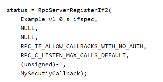
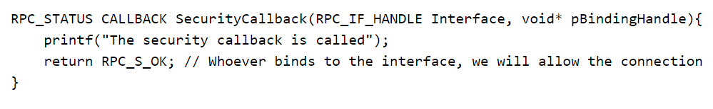
    The RPC_IF_ALLOW_CALLBACKS_WITH_NO_AUTH flag registers a security callback (e.g., MySecurityCallback), as shown in the examples below, which takes over security checks from the RPC runtime.

    RPCServerRegisterIf2 with security callback

    If the callback returns RPC_S_OK (mapped to 0), the client passes; otherwise, the client fails the security check.

    The security callback

    By default, the RPC runtime ( rpcrt4.dll library) handles client authentication using mechanisms such as NTLM or Kerberos. However, its behavior is influenced by two factors:

    1. The Restrict Unauthenticated RPC Clients policy:
    • If set to “None”, unauthenticated clients are allowed.
    • If set to “Authenticated”, only authenticated clients can connect.
  • The RPC_IF_ALLOW_CALLBACKS_WITH_NO_AUTH flag:
    This flag overrides the default policy, allowing the security callback to handle authentication even when clients are unauthenticated. The only exception is the “Authenticated without exceptions” policy value, which blocks all unauthenticated clients regardless of this flag.
  • This explains the exceptions we discussed earlier: they occur when interfaces inside RPC servers are registered with this flag, enabling unauthenticated connections even when the policy is set to “Authenticated”. The source and behavior of these exceptions should now be clear.

    Securing the endpoint

    As mentioned earlier, RPC servers can be accessed through various transport layers. For remote connections, TCP ports and named pipes are commonly used.

    When registering an endpoint for an RPC server using the RpcServerUseProtseqEp function, you can include a security descriptor (SD) to control who can connect to the endpoint. It’s important to note that this SD only applies to named pipes, not TCP ports. Additionally, it can also be used for local connections using ALPC ports as endpoints.

    Securing the interface

    Microsoft has introduced a newer version of the RpcServerRegisterIf2 function, called RpcServerRegisterIf3, which allows you to add an optional SD when registering your interface. This enables you to control who can connect directly to the interface.

    This security mechanism raises an important question: if an interface has registered an SD, and a client connects via TCP without authentication (authentication level = 1), how is the security check performed? Specifically, what security token is assigned to the client for the SD check?

    To answer this, we need to do some reverse engineering magic against the RPC runtime library ( rpcrt4.dll).

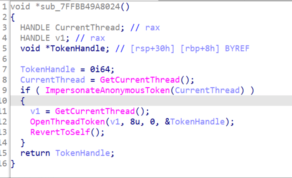
    The figure below shows the decompiled view from IDA for the function called when a client connects without authentication. As you can see, it uses the ImpersonateAnonymousToken function, which allows the thread to impersonate the system’s anonymous logon token. In other words, a client connecting via a TCP endpoint without authentication is represented as an anonymous user.

    Called function for unauthenticated clients

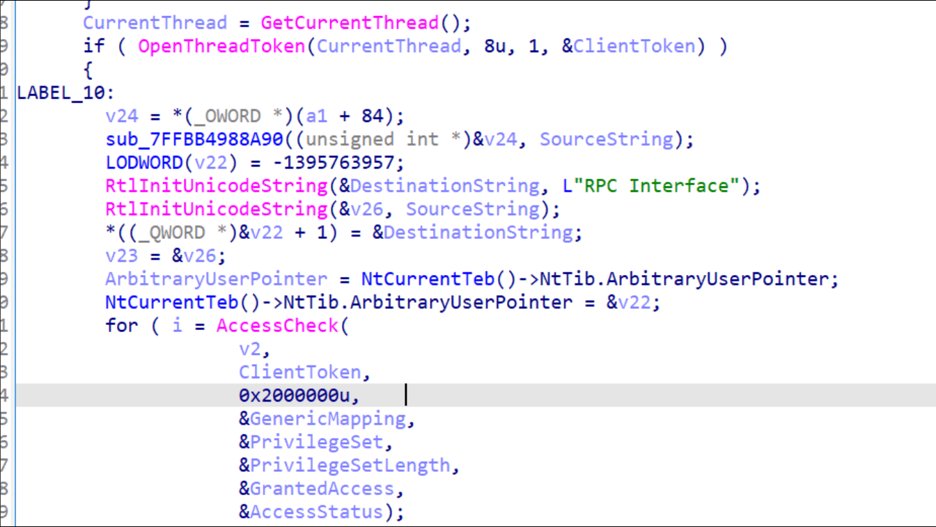
    After that, the access check is performed using the AccessCheck function:

    Access check

    Binding authentication

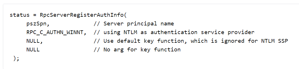
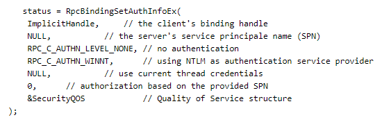
    The final RPC security issue to discuss is binding authentication. As you recall, the authentication method is specified in the binding packet (the first packet in an RPC connection). But what does that mean?

    An RPC server can register its preferred authentication method for clients using the RpcServerRegisterAuthInfo function. For instance, in the following example, NTLM authentication is registered as the chosen method.

    After that, the client can connect using RPCBindSetAuthInfoEx and specify the correct authentication service and authentication level.

    Now that we’ve covered RPC security, it’s time to answer questions about our interface (MS-NRPC): What security is applied on the server that defines this interface, and why were we able to access it without authentication?

    To do this, I used two approaches:

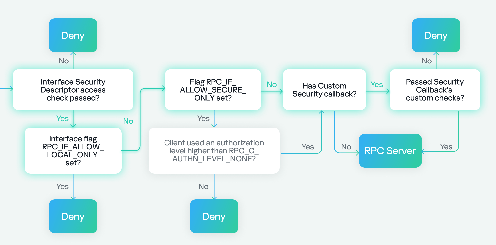
    1. Surface analysis: I examined the internal security checks of the RPC server using a flowchart from a great RPC toolkit. This chart provides valuable insight for our research, allowing us to analyze the security applied by the RPC server in more detail. I’ll go through it step by step, following the path described in the chart to conduct the investigation.
    2. In-depth analysis: In this approach, I interacted directly with the RPC server using reverse engineering to gain further insight into the enabled security.

    Surface analysis

    I will now attempt to determine the security mechanism used by the RPC server that’s related to the MS-NRPC (Netlogon) interface. I will assume that we are the RPC client calling a function from (MS-NRPC) Netlogon to enumerate domain information without using any authentication.

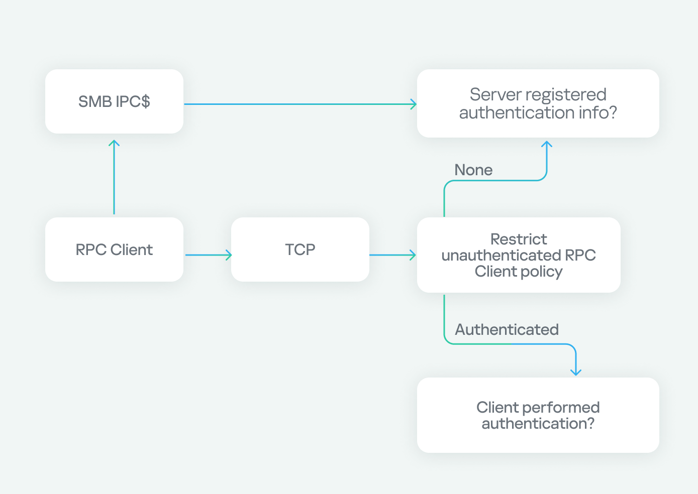
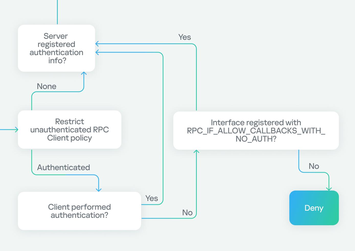
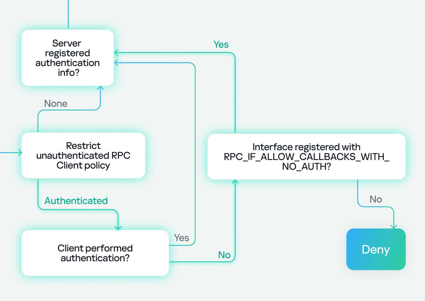
    Let’s start with transport protocols, as outlined in the flowchart:

    In the chart above, the RPC client has two options for connecting to the RPC server: via TCP or SMB named pipes. In our research, we are using TCP, which is highlighted.

    Next, we encounter the Restrict Unauthenticated RPC Client policy, which has two values: “None” or “Authenticated”. If set to “None”, we proceed to the next step. If set to “Authenticated”, a check is performed to see if the client has authenticated. If it has, the flow continues; however, if the client connects without authentication (as in our case), the RPC runtime checks for the RPC_IF_ALLOW_CALLBACKS_WITH_NO_AUTH flag and either accepts or denies the connection based on its presence.

    Since the policy is set to “Authenticated” and our client does not perform authentication, we need the RPC_IF_ALLOW_CALLBACKS_WITH_NO_AUTH flag to be registered in order to proceed to the next step, thereby making an exception to the policy. The presence of this flag allows us to conclude that a security callback has also been registered.

    Our path now looks like this:

    Next, there is another check to see if the server has registered an authentication service. If the server hasn’t registered one and the client tries to authenticate, it will be denied with an “authentication service unknown” error. However, if the client doesn’t attempt authentication, the process continues.

    If the server has registered an authentication service, the check against the endpoint (the SD registered via RpcServerUseProtseqEp) is performed. If the client passes this, another check is made against the interface SD (registered using RpcServerRegisterIf3). Failure to pass either of these checks will result in access being denied.

    In our case, we know the server has already registered an authentication service because it’s a well-known Microsoft protocol. We don’t need to worry about the endpoint check either, as it’s intended for clients connecting via named pipes. As for the interface security descriptor, we either passed this check if the SD doesn’t exist at all, or the SD does exist and it allows anonymous users (representing clients without authentication).

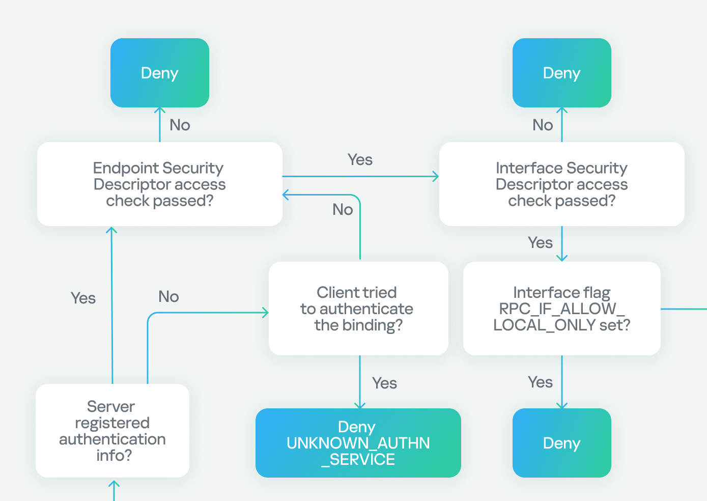
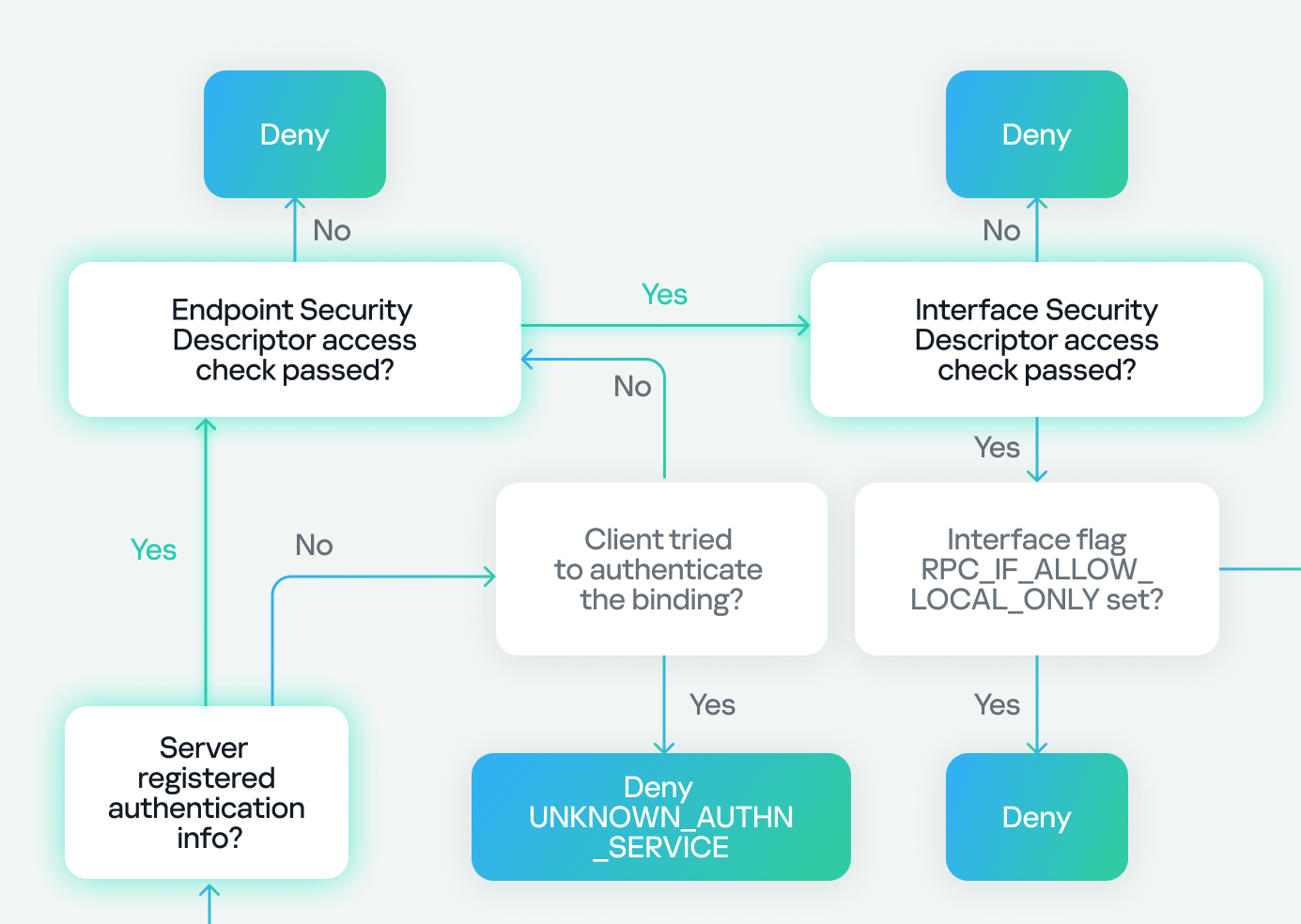
    Next, we check two flags: the first, RPC_IF_ALLOW_LOCAL_ONLY, determines if the interface can be accessed remotely, and the second checks for RPC_IF_ALLOW_SECURE_ONLY. If the latter is present, it ensures that we are using an authentication level higher than “None”, denying or allowing access based on the authentication level. Finally, we check for the presence of a security callback. If it doesn’t exist, we can access the server immediately. If it does exist, we must pass the custom checks within the security callback to access the server.

    In our case, we know that RPC_IF_ALLOW_LOCAL_ONLY doesn’t exist because we can access the interface remotely. We also know that RPC_IF_ALLOW_SECURE_ONLY isn’t present because we’re using an authentication level of “None”. Finally, we conclude that a security callback is registered based on the previous use of RPC_IF_ALLOW_CALLBACKS_WITH_NO_AUTH, and we successfully pass the security callback check to gain access to the server.

    Our final path looks like this:

    Surface analysis conclusion

    At this stage, we can conclude that the RPC server has the following characteristics:

    1. Regarding registration flags:
    • Has RPC_IF_ALLOW_CALLBACKS_WITH_NO_AUTH (indicating a security callback).
    • Doesn’t have RPC_IF_ALLOW_LOCAL_ONLY.
    • Doesn’t have RPC_IF_ALLOW_SECURE_ONLY.
  • Regarding the interface:
    • We’re unsure if it has a security descriptor (SD) or not.
  • Regarding registered binding authentication:
    • The RPC server registers authentication.

    As shown, the surface analysis couldn’t provide a complete security overview for the Netlogon (MS-NRPC) interface, so I decided to proceed with an in-depth analysis.

    In-depth analysis

    The goal of our in-depth analysis is to leverage reverse engineering techniques to assess the security of the RPC server under the MS-NRPC interface. As we saw before, the interface is accessible through the LSASS process, specifically via the Netlogon DLL. Here we have two approaches to analysis:

    1. Use automated tools to examine the security of the interface.
    2. Go directly to IDA and manually locate the interface and its associated security mechanisms.

    Automated tools

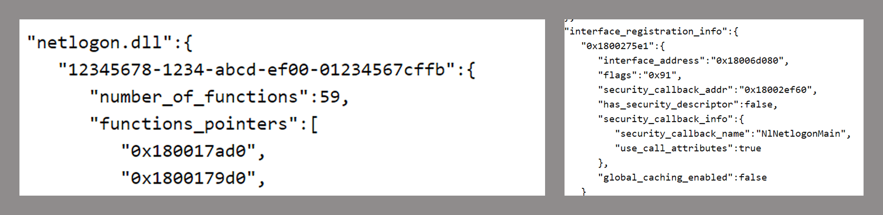
    Let’s begin with a tool called PE RPC Scraper. If we provide the Netlogon DLL as an argument, this tool reveals information about the RPC server, its interfaces, functions and security details.

    PE RPC Scraper output

    The output of the tool shows that it successfully identified the Netlogon interface (UUID) and confirmed that it contains 59 functions. It also revealed the presence of a security callback and a set of flags with a value of 0x91. After decoding this value, we can see that the following flags have been registered:

    • RPC_IF_ALLOW_CALLBACKS_WITH_NO_AUTH
    • RPC_IF_SEC_CACHE_PER_PROC
    • RPC_IF_AUTOLISTEN

    The output from PE RPC Scraper also indicates that the interface has no security descriptor.

    The information obtained from both the surface analysis and the automated tool provides the answer to the security bypass issue and allows me to conclude the investigation at this point. However, I personally don’t trust automated tools, and I have a good reason for that. So, for further confirmation, let’s dive into IDA.

    IDA like a superhero

    At this point, I’ve loaded netlogon.dll into IDA and started my investigation.

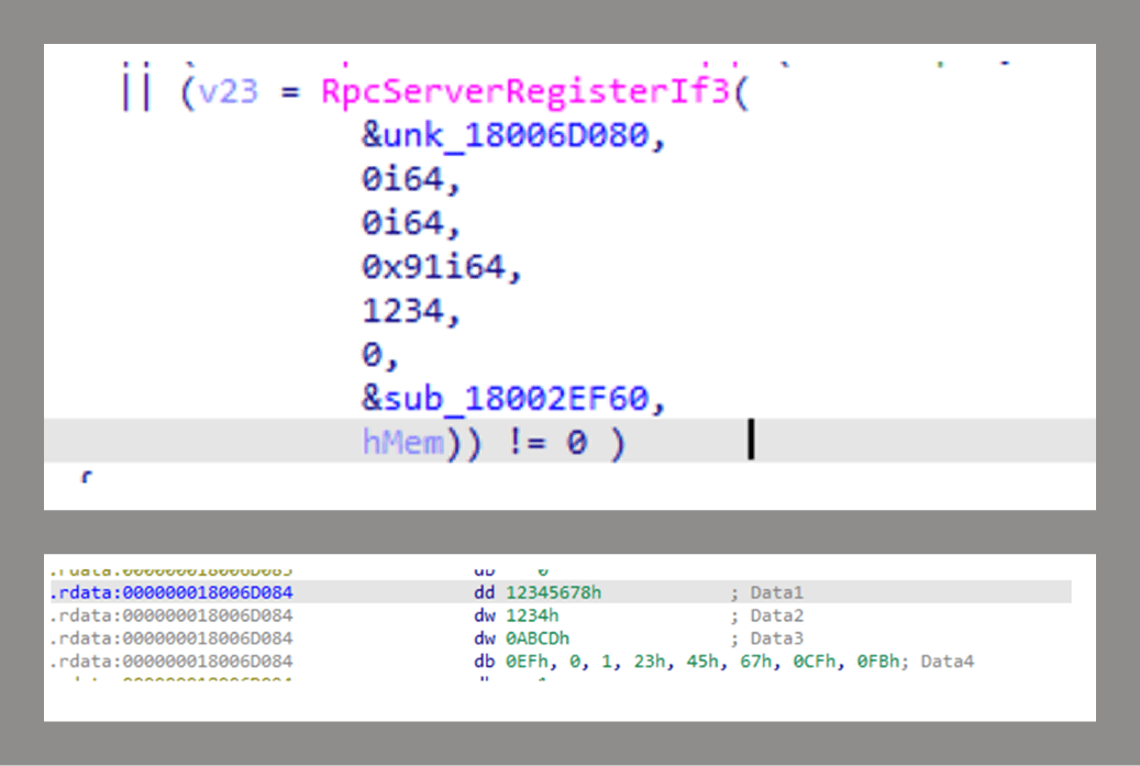
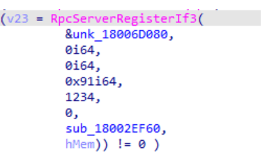
    A. Locate the interface

    The first step is to determine where the interface is registered. As shown in the figure below, the UUID registered using RPCServerRegisterIf3 is related to the MS-NRPC interface.

    MS-NRPC interface registration

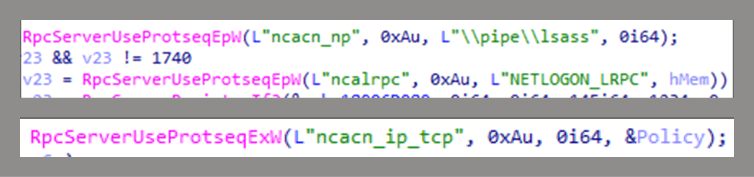
    B. Endpoint registration

    At this stage, we’ll check the endpoint registration for the server. As you can see in the screenshot below, RpcServerUseProtseqEpW and RpcServerUseProtseqExW have been used to register three endpoints:

    1. SMB named pipe, lsass
    2. Local ALPC port, NETLOGON_LRPC
    3. High dynamic TCP ports

    Endpoint registration

    C. Interface registration

    As I mentioned earlier, RpcServerRegisterIf3 is used to register the interface.

    Interface registration

    The function used the 0x91 value as a set of flags, which are: RPC_IF_ALLOW_CALLBACKS_WITH_NO_AUTH | RPC_IF_SEC_CACHE_PER_PROC | RPC_IF_AUTOLISTEN. RpcServerRegisterIf3 also has a security callback ( sub_18002EF60), in addition to a security descriptor ( hMem). This finding contradicts what was previously confirmed by an automated tool – that’s why I don’t trust them for reverse engineering.

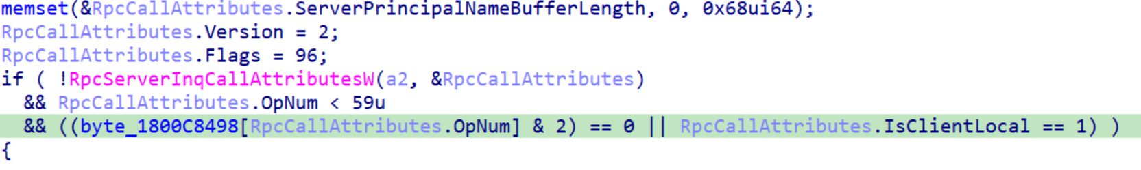
    D. Security callback

    Now let’s go inside the security callback and see how the security check is performed. From the screenshot below, we can see that RpcServerInqCallAttributesW is called first with the Flags field inside the RpcCallAttributes struct set to 96. After decoding this value, we can see that this function used two flags – RPC_QUERY_IS_CLIENT_LOCAL | RPC_QUERY_NO_AUTH_REQUIRED – to request the client information.

    The security callback has a condition statement.

    The security callback conditions

    First, the callback verifies that the RpcServerInqCallAttributesW function was called successfully, then it checks if the opnum is less than 59. If both previous conditions are met and the client is local, access to the server is granted. If the client is remote, the callback uses an access array (a matrix) to determine if the opnum is allowed to be called by the remote client.

    The access matrix is just hardcoded bytes in memory:

    Access matrix

    All of the previously mentioned functions in the MS-NRPC interface that can be accessed without authentication (as outlined in the table in the first part) pass the access matrix check.

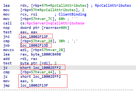
    Now, let’s analyze what happens when the conditions are met or not, using assembly language since the IDA decompiler tab lacks precise interpretations.

    The security callback conditions in assembly

    • For the security callback, as we mentioned earlier, returning 0 indicates a successful call.
    • For the first condition (RpcServerInqCallAttributesW), failure results in an error value.
    • For the second condition (operation number compared to 59), failure still returns 0. This only ensures that the matrix index doesn’t exceed its size and doesn’t validate implemented functions that are handled elsewhere.
    • For the third condition, if both the access matrix and local client checks fail, the callback returns 5 (access denied). If either of them succeeds, execution continues.

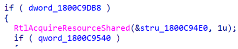
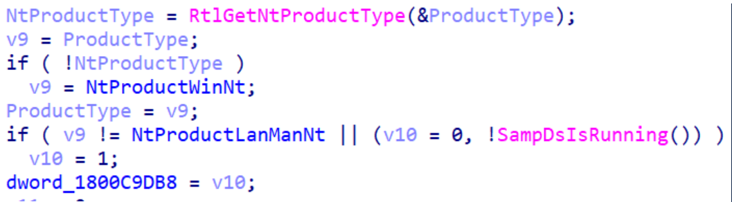
    If all of the above checks in the IF statement are passed, the security callback proceeds to check the Windows version with another IF statement that verifies the value of a DWORD in memory.

    The second IF statement

    This DWORD is initialized using the code shown below. The value is set based on whether or not the machine is a domain controller (DC).

    Checking the machine type

    • If the machine is a DC, execution continues and returns 0, indicating that the security callback check was successfully passed.
    • If it is not a DC, further checks are performed.

    This sequence of checks shows that passing the security callback for the remote client on a DC requires only that the access matrix check be successfully passed.

    E. Interface security descriptor

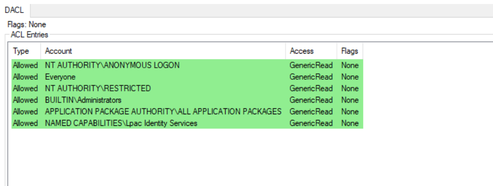
    As we saw before, the security descriptor is assigned through the RpcServerRegisterIf3 function. It is set up by calling another function that contains many instructions. The security descriptor definition language (SDDL) for the security descriptor is shown below.

    SDDL for security descriptor

    From the SDDL, we can see that the following groups of users have read access: Anonymous Logon, Everyone, Restricted Code, Built-in Administrators, Application Package, and a specific security identifier (SID).

    But I ran into a problem. The function where the security descriptor is set up contained numerous operations, and I wasn’t sure if any changes had been made to the SDDL representation of the security descriptor. That’s why I decided to find an alternative method to verify that the SDDL interpretation remained the same.

    To achieve this goal, I considered two approaches:

    1. Memory search: I considered searching memory at runtime for the known value in the header of the relative security descriptor to intercept and extract the discretionary access control list (DACL) inside LSASS. However, since this involves interacting with the LSASS process, which is risky, I took a different approach.
    2. ALPC Port Security Descriptor: The ALPC port NETLOGON_LRPC, registered during endpoint setup, shares the same security descriptor as the interface:

    Endpoint and interface registration

    Using the ALPC port’s name, I used the NtObjectManager PowerShell module (you can use any programming alternative) to extract the security descriptor from the ALPC port.

    Extracting the SD from the ALPC port in PowerShell

    After that, I obtained the DACL from the security descriptor.

    Security descriptor for ALPC port

    The screenshot above shows that the DACL obtained from the ALPC port’s security descriptor matches the SDDL representation we obtained earlier. As we can see in the first line of the ACL entries, anonymous login is allowed on the interface, which explains why we can pass the security descriptor access check for the interface (if there is no client token, the Anonymous LOGON token is assigned).

    In-depth analysis conclusion

    From the in-depth analysis, we now have the whole scenario of the MS-NRPC security mechanism, which allowed us to understand how we could successfully pass the security checks of the MS-NRPC interface and call multiple functions without authentication, even if the RPC policy is set to “Authenticated”.

    To summarize, here’s how we were able to bypass the security of MS-NRPC:

    1. Registration flags:
    2. We found that the interface has the RPC_IF_ALLOW_CALLBACKS_WITH_NO_AUTH flag: for this reason, we were able to get past the RPC policy.

    3. Security callback:
    4. We found that this flag has a security callback, which in our case is used to check if we pass the check against the access array, and all of our functions passed the check.

    5. Interface security descriptor:

    The interface has a security descriptor that permits multiple user groups to connect, including anonymous users. Since we are using no authentication, the access check is performed against the anonymous user, allowing to access the interface’s functions.

    Research conclusion

    At the end of this part and my research, I hope I was able to provide all the details related to this research and the approaches that I used. I also hope that you are now able to understand why we have this kind of no-authentication enumeration. Furthermore, I hope you are now equipped to develop your own ways to detect this kind of activity.

    Thank you for reading, and see you soon with more research projects.

MIL OSI Economics

  • MIL-OSI Europe: Answer to a written question – Weapons trafficking to Sudan – E-000350/2025(ASW)

    Source: European Parliament

    Since the start of the conflict in Sudan in April 2023, the European External Action Service has been discussing the situation in this country during its political dialogues and exchanges with the Emirati authorities at various levels.

    The EU Special Representative for the Horn of Africa, has also been engaging with the Emirati and other regional stakeholders. In this context, the EU representatives have raised concerns about reported United Arab Emirates (UAE) support to the rapid support forces, while emphasising the importance of the UAE’s constructive engagement for reaching a sustainable cease-fire in Sudan.

    The negotiated outcome documents of two high-level meetings on Sudan co-organised by the EU, Germany and France in New York[1] and Paris[2] — attended by UAE — urge foreign actors to cease support to the warring sides.

    Situation in Sudan has also been discussed in the meetings with the Gulf Cooperation Council (GCC), including the first EU-GCC Summit in Brussels on 16 October 2024, where the EU and GCC leaders (UAE represented at the level of Deputy Prime Minister and Minister of Finance) underscored the importance of stopping the war and eventually returning to a political process leading to civilian rule in Sudan, and urged the Sudanese armed forces and the rapid support forces to engage seriously and effectively with crisis resolution initiatives, including the Jeddah platform.

    The Commission will continue to follow closely the conflict in Sudan and engage with the key regional stakeholders, including the UAE, in the regional efforts aimed at achieving a lasting peace and justice in Sudan. In the meantime, the EU has already adopted three listings of restrictive measures[3], including against entities that are based in the UAE, and stand ready to consider additional sanctions against those who are fuelling the war.

    • [1] https://www.auswaertiges-amt.de/en/newsroom/news/2677588-2677588
    • [2] https://www.diplomatie.gouv.fr/en/country-files/sudan/news/article/ministerial-meeting-for-advancing-the-sudan-peace-initiatives-paris-le-15-04-24
    • [3] https://eur-lex.europa.eu/legal-content/EN/TXT/?uri=OJ:L_202403154
    Last updated: 4 April 2025

    MIL OSI Europe News

  • MIL-OSI United Kingdom: Environment Agency secures proceeds of crime award for £313,382

    Source: United Kingdom – Executive Government & Departments

    Press release

    Environment Agency secures proceeds of crime award for £313,382

    The Environment Agency has secured a proceeds of crime judgment for £313,382.45 against men from Northampton who ran an illegal waste tyre site.

    Multiple piles of used tyres

    A pair of Northampton men are to pay for their role in an illegal tyre waste site in Daventry.

    At Northampton crown court on Friday 28 March, a confiscation hearing concluded against Nimesh Patel, aged 52, of Jasper Walk, Thorplands Brook, and Andrew Eyre, aged 55, of Poppyfield Road, Wootton.

    Patel was ordered to pay £175,013.93 and a £122 surcharge, while Eyre received an order for £138,368.52 and £140 surcharge.

    Both men have been given 3 months to pay or will face 3 and 2 years in prison respectively. Eyre was also fined £250 for breach of his first suspended sentence of imprisonment he received in January 2020.

    The duo had been prosecuted for their part in running a waste tyre site, Synergy Tyres (Midland) Ltd., at Broad March Industrial Estate in Daventry.

    In September 2024, Eyre, a director of the company, had received an 18-week prison sentence that was suspended for 12 months, on condition that he completed 30 days of rehabilitation activities.

    Patel, who had been operations manager, was sentenced to 14 weeks’ imprisonment, suspended for 12 months, on condition that he perform 80 hours of unpaid work.

    The Daventry site operated without an environmental permit and tyres were stored in an unsafe manner, creating a significant fire-risk and, therefore, a high-pollution risk. 

    From February 2020, Environment Agency officers inspected the site multiple times over the course of a year, and each time witnessed huge amounts of tyres that exceeded the legal limit.

    Paperwork obtained showed that waste tyres were continuously delivered to the site throughout the year, with Eyre being the sole director, and Patel having day-to-day control of the site. 

    The investigation found that the 40-tonne weekly limit for the storage or treatment of waste tyres was exceeded in 52 out of the 59 weeks analysed. 

    This probe followed a court case in January 2020 for the same nature of offending, when Synergy Tyres (Midland) Ltd. had been fined £11,250. Eyre received a suspended 12-month sentence, suspended for 24 months, on condition that he stayed out of trouble and performed 150 hours of unpaid work.

    At that hearing, John Mullen, then 59, of Frankston Avenue, Milton Keynes, received a 6-month community order with a requirement that he completed 15 days of rehabilitation activities.

    At the confiscation hearing on Friday 28 March, Mullen received an order for £1 and a surcharge of £85.

    Eyre and Mullen had been joint directors of a company called IN4 Ltd until February 2017, when Eyre retired, leaving Mullen as the sole director.

    That company was found by investigators in March 2017 to be storing more than 1,300 tonnes of tyres – more than 15 times the amount allowed under its environmental permit.

    Peter Stark, enforcement leader for the Environment Agency in Lincolnshire and Northamptonshire, said:

    “The case shows that we’re not just content to prosecute those who run illegal waste sites, we’ll also come after them to get back the profits they made from their illegal activities and to recoup taxpayers’ money spent on pursuing them.

    “Waste crime can have a serious environmental impact that puts communities at risk and undermines legitimate business and the investment and economic growth that go with it.

    “We support legitimate businesses and we are proactively supporting them by disrupting and stopping the criminal element backed up by the threat of tough enforcement as in this case.

    “We continue to use intelligence-led approaches to target the most serious crimes and evaluate which interventions are most effective.

    “If you see or suspect waste crime is being committed we urge you to report it immediately to CrimeStoppers on 0800 555 111.”

    Updates to this page

    Published 4 April 2025

    MIL OSI United Kingdom

  • MIL-OSI United Kingdom: Repairing Roker Pier

    Source: City of Sunderland

    A 12 week programme of repairs for Sunderland’s storm damaged Roker Pier is due to begin at the end of this month.

    The grade II listed pier has been closed to the public for safety reasons since it was damaged by Storm Babet in October 2023.

    Planning approval for repair works was granted in January this year. The £236,000 repair programme is timetabled to start on Thursday 24 April and scheduled to be complete by Thursday 31 July.

    The City Council’s Cabinet Member for Business, Regeneration and Housing, Councillor Kevin Johnston said: “We all know and recognise that Roker Pier is a key part of our seafront, our heritage and our sea defences for the city and the Port of Sunderland.

    “The very heavy seas of Storm Babet washed away several sections of the deck near the lighthouse, railings were washed away, along with other sections of decking and coping stones.

    “Most of this damage was to the northern and eastern facing sections of the pier and, of course, we have a duty to keep the public safe so we’ve kept the pier closed.

    “Roker Pier and coastal structures all along the east coast suffered damage in Storm Babet. I’m pleased to confirm we are getting on with the repairs programme. This programme is a complex marine engineering job and, weather permitting, we look forward to seeing Roker Pier open again to the public by August.”

    Approximately 100 metres (more than 300ft) of railings were washed away in Storm Babet and as a Grade II listed structure the council has worked closely with heritage organisations on the repairs programme. The council has also had to be mindful of roosting and nesting seabirds.

    The contractor for the repairs is North East-based Southbay Civil Engineering Limited, who are currently working on repairs to the River Tyne piers following damaged caused by Storm Babet. They previously worked on Roker Pier slab repairs in 2014.

    Antony Ballantyne, Operations Director for Southbay Civil Engineering Limited, said: “As a local contractor, we are delighted to be involved in the delivery of a project that will retain one of the North East region’s most iconic coastal structures.

    “As a specialist marine contractor we are aware of the constant pressures such marine structures are under through events such as Storm Babet. Using our specialist experience together with that of our supply chain, we will ensure the aesthetic appearance of this grade II listed structure is maintained.”

    MIL OSI United Kingdom

  • MIL-OSI United Kingdom: Sustainable flood memories

    Source: United Kingdom – Executive Government & Departments

    Case study

    Sustainable flood memories

    Sustainable flood memory emphasises the importance of remembering and learning from past flood events to enhance community resilience and adaptive strategies.

    Reviewing flood memory documents. Image credit: Sustainable Flood Memory project.

    Sustainable flood memories and the development of community resilience to future flood risk

    Lindsey McEwen 1, Joanne Garde-Hansen2, Owain Jones3, Andrew Holmes1 and Franz Krause4

    1 Centre for Water, Communities and Resilience, College of Arts, Technology and Environment, University of West England Bristol, United Kingdom

    2 School of Media and Communication, University of Warwick, United Kingdom

    3 School of Humanities, Bath Spa University, United Kingdom

    4 Department of Social and Cultural Anthropology, University of Cologne, Germany

    Funded by the UK Economic and Social Research Council from 2011 to 2015, the Sustainable Flood Memories (SFM) project created a conceptual framework to enhance community resilience against flooding. SFM empowers communities to navigate flood risk management through local knowledge and collective memory. The lessons learned from the SFM project provided insights for building a more resilient future by engaging communities, preserving local knowledge, and fostering adaptive learning.

    SFM acknowledges the importance of individual and community experiences with flooding.

    Lindsey McEwen and others (2016) described how sustainable flood memories can come from many sources including (page 17):

    narratives, oral and archived histories, physical marks, artefacts and material practices in the landscape, and media representing floods, comprising folk memories, autobiographical accounts, personal stories and anecdotes of previous floods (routine–severe) and their impacts.

    The project had 2 components. The first was a comparative study of 3 communities that experienced flooding involving local council members, flood action group representatives, and emergency services. The project culminated in a conceptual framework for SFM emphasising the role of local knowledge and experiences in decision-making processes.

    The second component used digital storytelling as a tool for adaptive learning. In partnership with the Environment Agency and local government, 21 digital stories were co-created with community members to address various aspects of community flood preparedness. These narratives preserved individual and collective memories and served as educational resources for at-risk communities.

    Digital flood story: A community

    Impact

    The project helped to improve community resilience, archive local flood knowledge, engage various sectors and support training.

    The project increased community awareness and engagement by fostering a collective memory of past floods and as a result, communities became more aware of their vulnerabilities. This increased community awareness helped to encourage local participation in flood management discussions, promoting ownership and responsibility for flood preparedness. It enhanced resilience given that communities learned from past flood events and could develop better preparedness strategies. This was particularly crucial for regions where extreme weather events may not be within living memory, necessitating a balance between remembering and forgetting.

    Former CEO National Flood Forum (2025) said:

    Detailed knowledge about very local flood risk and flooding incidents is incredibly important, both when combining it with the skills needed to better manage flood risk and in supporting communities to build their resilience. But all too often it gets lost from one generation to another and as people move away.

    Communities were also able to protect their local flood knowledge by archiving community-generated flood knowledge. This was important to ensure that informal histories were preserved alongside formal documentation.

    Property Flood Resilience Champion, Flood Mary (2025) said:

    Local flood memory is an essential part of the journey to flood resilience. Having local knowledge of flood risk is so important. I remember someone knocking [at] my door to find out if I knew about the local flood history, as they were about to buy a house in my street. Having somewhere to point people to, which has both new and historical flood risk information keeps flood risk real. Pulling all partners together to share their knowledge and expertise is an excellent way to make this happen.

    In addition, policymakers could leverage historical flood data and community narratives to create tailored flood risk management policies. The data could also improve infrastructure planning, ensuring that new developments are resilient to potential future flooding scenarios. They can also support training. The digital stories co-created during the project have been used in training for Environment Agency community officers and shared amongst at-risk community groups, demonstrating their practical application.

    The SFM project sparked discussions across various sectors, bringing in new voices and perspectives, particularly from the GLAM (Galleries, Libraries, Archives, and Museums) sector. Projects like Gloucestershire Archives’ Green Pledge Project have adopted SFM methodologies to enhance community engagement.

    Learning & Outreach Officer, Green Pledge Project, Gloucestershire Heritage Hub (2025) said:

    The Green Pledge Project at Gloucestershire Archives is about connecting people with archival material relating to our environmental history. We are using the records to inform and inspire people to live more sustainably. The creation of material, such as those made for the SFM project, which are stored at Gloucestershire Archives, enable us to do that in a very direct way. They have been shared in project presentations and event, sparking discussions around past floods and community resilience for future ones.

    Resources

    Centre for Floods, Communities and Resilience (CFCR). Sustainable Flood Memories and Community Resilience. Available at: https://esrcfloodmemories.wordpress.com/ (Accessed: 25 March 2025).

    Garde-Hansen, J., McEwen, L. J., Holmes, A. and Jones, O. (2017).  Sustainable Flood Memory: Remembering as Resilience. Memory Studies 10(4), 384–405. Available at: doi.org/10.1177/1750698016667453 (Accessed: 25 March 2025).

    Garde-Hansen J., McEwen L. J. and Jones O. (2016). Towards a memo-techno-ecology: mediating memories of extreme flooding in resilient communities. In Hajek, A. Lohmeier, L. and Pentzold, C. (eds.) Social Memory in a Mediated World: Remembering in troubled times, Palgrave Macmillan. Pp 55-73.

    Holmes, A. and McEwen L. J. (2020). How to exchange stories of local flood resilience from flood rich areas to the flooded areas of the future.  Environmental Communication 14(5), 597-613. Available at: doi.org/10.1080/17524032.2019.1697325 (Accessed: 25 March 2025).

    McEwen, L. J., Garde-Hansen, J., Holmes, A., Jones, O. and Krause, F. (2016). Sustainable Flood Memories, Lay knowledges and the Development of Community Resilience to Future Flood Risk. Transactions of the Institute of British Geographers 42 (1), 14-28. Available at: doi.org/10.1111/tran.12149 (Accessed: 25 March 2025).

    McEwen, L. J. and Holmes, A. (2017). Sustainable Flood Memories: Developing the concept, process and practice in flood risk. In Vinet, F (ed.) Floods Vol 2: Risk Management. Editions ISTE (published in English and French) Chapter 10, 141-153. 

    McEwen L. J., Garde-Hansen, J, Robertson, I and Holmes, A. (2018). Exploring the changing nature of flood archives: community capital for flood resilience. In Metzger, A and Linton, J (eds.) La Crue, l’inondation: un patrimoine. L’Harmattan Publishing House, France. 

    United Nations Office for Disaster and Risk Reduction (UNDRR). PreventionWeb: Floods, Memories, and Resilience. Available at: https://www.preventionweb.net/news/floods-memories-and-resilience (Accessed: 25 March 2025).

    Funder 

    • UK Economic and Social Research Council (ESRC)

    Collaborators

    • Environment Agency
    • Local government
    • UWE Bristol
    • Civil society organisations

    Research period  

    • 2011 to 2015

    Impact period  

    • Ongoing

    Impact country  

    • UK
    • France

    Contributing to the areas of research interest

    • 2 – Resilience and adaptation to flooding and coastal change

    Updates to this page

    Published 4 April 2025

    MIL OSI United Kingdom

  • MIL-OSI United Kingdom: Flood Hydrology Roadmap

    Source: United Kingdom – Executive Government & Departments

    Case study

    Flood Hydrology Roadmap

    The UK’s Flood Hydrology Roadmap is designed to safeguard communities, infrastructure, and natural environments from the escalating risks of flooding.

    Recovering from winter floods 2015-2016, York. Image credit: Environment Agency.

    Flood Hydrology Roadmap

    Sean Longfield1, Sue Manson 1 and Anita Asadullah 1

    1 Environment Agency, United Kingdom

    The UK’s Flood Hydrology Roadmap, led by the Environment Agency, was published in 2022. It charted a course from 2021 to 2046 to guide the UK towards a more resilient, scientifically driven, and collaborative approach to improve flood hydrology.

    The roadmap emerged in response to several strategic drivers. Flood hydrology underpins investment decisions across flood and coastal risk management, with an estimated £6 billion of investment in the UK planned between 2022 and 2028. This, combined with a need to support the implementation of flood risk management strategies across the UK required a new long-term vision and direction for flood hydrology.

    In response, the roadmap provided a UK-wide plan of action to improve ways of working, data, methods and scientific understanding in hydrology so that risk information was robust and could continue to support activities for safeguarding communities, infrastructure, and natural environments from the escalating risks of flooding. It considered all inland flood sources—rivers, surface water, groundwater, and reservoirs across England, Wales, Scotland, and Northern Ireland.

    The roadmap for UK flood hydrology. Image credit: Environment Agency.

    Impact

    The roadmap’s vision for the next 25 years is that society will have improved hydrological information and understanding to manage flood hazards in a changing world; flood hydrology and whole-system process understanding will be underpinned by excellent evidence with quantified uncertainty. Leadership and collaboration are crucial to achieving this vision. It aims to bring new science into operational practice, developing the next generation of methods to increase flood resilience and adaptation to a changing climate. The roadmap’s success will be underpinned by cohesive action and gaining funding, estimated between £110 and £165 million over 25 years to 2046.

    The Environment Agency secured £6 million over 6 years to start delivering on the roadmap and established the Flood Hydrology Improvements Programme (FHIP). Through FHIP, the Environment Agency made the sub-daily flow and rainfall data publicly available which enabled valuable research into flood periodicity to be conducted. Another outcome was addressing gaps in hydrometric data through a project that preserved significant amounts of data. In addition, it enabled a UK-wide skills survey providing information on the state of the hydrological expertise in the UK. FHIP is leading on a benchmarking process for hydrological models, making it possible to appraise and bring new scientific methods into practice.

    The roadmap, with support from FHIP, has also enabled experts to work together more effectively. This included setting up a flood hydrology scientific and technical advice group.

    Rob Lamb, JBA Trust director and member of roadmap steering group (2022) said:

    By bringing together the views of scientists and practitioners from a wide range of disciplines and sectors, the roadmap advances flood hydrology both as a technical discipline and as a profession. It is a landmark report that will shape hydrology and flood management for years to come.

    The strategic direction is overseen by a governance board, which uses the roadmap to guide activities, coordinate action and share knowledge. It also reinforces opportunities for collaboration across organisations.

    Cordelia Menmuir, Senior Manager Hydrology and Flooding for Scottish Environment Protection Agency (SEPA) and Chair of the Governance Board (2025) said:

    It is a privilege to be able to Chair the Governance Board that oversees such a talented and passionate group of individuals all working towards the same common goal. Moving forward we are actively seeking out new ways to facilitate the involvement of any individual or organisation who believes they have something they can offer, and I would encourage all those who work in hydrology to consider contributing.

    Andrew Wall, National Flood Risk Services Manager at Natural Resources Wales (NRW) (2025) said:

    We have welcomed the opportunity for agencies across the UK to come together to review flood hydrology and develop a roadmap for future improvement to our data and techniques. NRW is looking forward to continuing to work alongside our partners in this important effort and playing a key role in the development and delivery of the vision for flood hydrology across the UK.

    Resources 

    British Hydrological Society. (2022). UK Flood Hydrology Roadmap and Flood Hydrology Improvements Programme. Available at: https://www.hydrology.org.uk/Flood_Hydrology_Roadmap.php (Accessed: 25 March 2025).

    Environment Agency. (2021). Flood hydrology roadmap. Available at: https://www.gov.uk/flood-and-coastal-erosion-risk-management-research-reports/flood-hydrology-roadmap (Accessed: 25 March 2025).

    Environment Agency. (2025). UK Flood Hydrology Roadmap – Engage Environment Agency. Available at: https://engageenvironmentagency.uk (Accessed: 25 March 2025).

    Lamb, R., Longfield, S., Manson, S., Cloke, H., Pilling, C., Reynard, N., Sheppard, N., Asadullah, A., Vaughan, M., Fowler, H.J. and Beven, K.J. (2022). The future of flood hydrology in the UK. Hydrology Research 53(10): 1286-1303. Available at: doi.org/10.2166/nh.2022.053 (Accessed: 25 March 2025).

    Funder 

    The research project was funded by the Flood and Coastal Erosion Risk Management (FCERM) research and development programme.  

    Collaborators  

    • A community derived project with around 50 organisations from public sector, industry and academia, now governed by the Environment Agency, Natural Resources Wales, Scottish Environmental Protection Agency, the Department for Infrastructure, Northern Ireland, British Hydrological Society and UK Research and Innovation. For a full list of contributors see the report.

    Research period  

    • 2018 to 2022 

    Impact period   

    • 2021 to 2046 

    Impact country  

    • England
    • Wales
    • Scotland
    • Northern Ireland

    Contributing to areas of research interest

    • 1 – Understanding future flood and coastal erosion risk

    Updates to this page

    Published 4 April 2025

    MIL OSI United Kingdom

  • MIL-OSI United Kingdom: Thames Barrier future closure numbers tool

    Source: United Kingdom – Executive Government & Departments

    Case study

    Thames Barrier future closure numbers tool

    How adaptive planning approaches are being used to prepare the Thames Estuary for rising sea levels and changing river flows.

    Thames barrier close up. Image credit: Environment Agency.

    Thames Estuary 2100 – Projections of future Thames Barrier average annual closure numbers

    James Brand 1 and Ivan Haigh 2

    1 Environment Agency, United Kingdom

    2 Ocean and Earth Science, University of Southampton

    The Environment Agency collaborated with Professor Ivan Haigh from the University of Southampton in 2021 to 2022 to create a tool to model projected future annual closure numbers of the Thames Barrier. The Thames Estuary flood defences, including the Thames Barrier, protect over 1.4 million people and £321 billion worth of residential property in London and the wider estuary (Environment Agency, 2021). To make sure that the Thames Barrier continues to operate reliably, the number of closures needs to be kept at or below an average of 50 per year to allow sufficient time for maintenance.

    The projection tool that the team developed uses a Monte-Carlo modelling approach. It simulates a range of possible outcomes to predict minimum, maximum, and average projections for numbers of future barrier closures. As a result, the tool provides a more comprehensive understanding of future closure numbers which allows planners to consider not just sea level rise but also the effects of tidal cycles and storm surges, forecasting improvements, and even potential shifts in fluvial flow.

    Impact

    The level of detail provided by the projection tool enabled the Thames Estuary 2100 Plan (TE2100) to make more informed decisions about critical deadlines. For example, the tool’s insights led to an adjustment of the first defence-raising deadline for London from 2065 to 2050—15 years earlier than initially planned. This major shift reflected not only updated climate data, but also the anticipated impact of inter-annual tidal cycle peaks on closure frequency.

    Beyond simply updating timelines, the tool’s projections enable the Environment Agency to plan strategically. It allows the Environment Agency to test future scenarios where forecasting accuracy does not achieve expected improvements, preparing for possible adjustments in barrier operations and maintenance or further changes to defence raising deadlines.  

    The tool also helps planners evaluate how future maintenance schedules could be optimised to reduce disruptions during periods with a higher likelihood of closures. This insight is particularly valuable for long-term contingency planning, as it offers flexibility for adapting both routine and large-scale maintenance projects.

    Professor Ivan Haigh spoke about the importance of the tool (2024):

    Around the world there are more than 50 storm surge barriers in operation protecting tens of millions of people and trillions of pounds of property and infrastructure. However, with climate change, surge barriers are closing increasingly often, and closures are now occurring in months when they typically have not occurred in the past. Increased use of surge barriers in the future has critical implications for barrier management, maintenance and operation.

    Working closely with staff in the Environment Agency, we have produced a flexible tool that can estimate how much more often and which times of the year operators are likely to have to use their barriers. Working with the Environment Agency, and other barrier operators in the Netherlands and USA, we have considered the implications of this on future barrier management and maintenance, and identified when in the future barriers might have to be upgraded and replaced.

    The tool supported a path forward in climate-resilient infrastructure. The adaptability and foresight embedded in this approach make it a model for global flood risk management. Tools like the barrier closure projection tool have proven indispensable for maintaining the balance between protection, maintenance, and operational efficacy. The use of the tool has demonstrated that proactive steps are being taken to safeguard London’s future and that the insights gained can benefit cities and flood defences across the globe.

    Dr James Brand added (2025):

    This tool has provided us with vital new evidence to inform our strategic planning for managing London’s tidal flood risk. It helps us to test different scenarios for managing the flood defence system and allows us to make better informed decisions when setting deadlines for implementing improvements to the tidal flood defence system.

    Resources

    Department of Environment, Food and Rural Affairs (Defra) and Environment Agency. (2023). Thames Estuary 2100 Plan. Available at: https://www.gov.uk/government/collections/thames-estuary-2100-te2100 (Accessed: 24 March 2025).

    Environment Agency. (2021). Thames Estuary 2100: 10-year monitoring review (2021). Available at: https://www.gov.uk/government/publications/thames-estuary-2100 (Accessed: 24 March 2025).

    Haigh, I., D’Arcy, E., Brand, J., Inavatillah, A., Trace-Kleeberg, S., Walraven, M., Saman, K., Batchelor, A., Lewis, C., Barlow, N.L.M., Thompson, P., O’Brien, P. and Marzion, R. (pre-print). Rapid Acceleration in the Number of Closures of Storm Surge Barriers in the Future: A New Tool for Estimating Barrier Closures. Available at: https://www.preprints.org/manuscript/202410.2298/v1 (Accessed: 24 March 2025).

    Funder

    • Environment Agency

    Research period 

    • 2021 to 2022

    Impact period 

    • 2023 and out to 2100

    Impact country 

    • England
    • Variants are also being used in the Netherlands and the USA

    Contributing to the areas of research interest

    • 6 – Digital technology

    Updates to this page

    Published 4 April 2025

    MIL OSI United Kingdom

  • MIL-OSI United Kingdom: Wetlands and coastal protection

    Source: United Kingdom – Executive Government & Departments

    Case study

    Wetlands and coastal protection

    Wetlands can act as natural buffers to reduce wave energy.

    Steart Marshes, Steart, Somerset. Image credit Environment Agency

    Natural coastal protection and risk reduction by intertidal wetlands

    Iris Möller1 and Tom Spencer2

    1 Department of Geography, Trinity College, Dublin, Ireland

    2 Cambridge Coastal Research Unit, University of Cambridge, United Kingdom

    Natural flood management (NFM) protects, restores or emulates the natural functions of rivers, floodplains, catchments and the coast to reduce flooding and coastal erosion. It can take the form of wetland restoration. Wetlands can be very beneficial for reducing flood risks while also providing wider environmental benefits.

    Research from the Cambridge Coastal Research Unit (CCRU) demonstrated the critical role that coastal wetlands play as natural buffers against storm impacts. This work not only transformed understanding and attitudes toward coastal ecosystems, but has influenced policy and practice.

    Impact

    The findings from CCRU helped to shift the narrative on coastal management. The UK Climate Change Risk Assessment (CCRA2) highlighted flooding and coastal change as the highest climate risk for the UK, and identified an urgent need for effective, sustainable solutions. With rising sea levels projected to impact approximately 1,000km (20%) of England’s coastal defences by 2100, reliance solely on hard engineering is becoming increasingly untenable (Environment Agency, 2024).

    The CCRU’s extensive research provided compelling evidence that coastal wetlands, such as salt marshes, significantly dissipated wave energy during storms, and by doing so helped to protect coastal communities and infrastructure. By acting as natural barriers, these ecosystems reduce the wave heights that reach man-made structures, either decreasing the need for hard engineering solutions or the cost of their construction and maintenance where they are needed.

    The CCRU’s work was pivotal in advocating for the policy of ‘managed realignment.’ This strategy promotes restoring natural habitats by allowing the coastline to adjust in a way that benefits both the environment and human communities. By creating new habitat areas and reducing maintenance costs associated with artificial defences, managed realignment represents an approach to coastal management that aligns with both ecological and economic goals.

    Through field campaigns and experimental research, the CCRU quantified the extent to which wave energy is mitigated by coastal wetlands. Studies conducted in Essex estuaries and Morecambe Bay found that salt marshes can reduce wave heights by 15-20% during extreme storms, enhancing the stability of adjacent infrastructure. This research considered various factors, including water depth, wave height, vegetation type, and sediment characteristics, providing a nuanced understanding of how these ecosystems offer coastal protection.

    Experiments conducted in the world’s longest wave flume illustrated that even a 40 metre wide band of salt marsh can effectively lower storm wave heights, with a notable percentage of this reduction attributed to the plants and the stable sediment they create. This evidence was important for informing coastal management practices and illustrating the benefits of preserving and restoring natural habitats.

    In 2017 the Environment Agency published the ‘Working with natural processes evidence directory for flood and coastal risk management’ and it was updated in 2024. These publications referenced field and laboratory work from this research which demonstrated that saltmarshes can reduce wave heights under extreme wave and water level conditions.

    Principal Scientist, Flood & Coastal Risk Management Research, Environment Agency (2017) said:

    This evidence [from the CCRU] has been very important in helping [the Environment Agency] develop and publish our Natural Flood Management evidence base…to mainstream more natural approaches to flood and coastal erosion risk management.

    In addition to influencing policy, the CCRU has developed models and visualisation tools to help coastal managers understand and implement natural coastal protection strategies. By integrating scientific research with practical applications, these tools empower decision-makers to incorporate wetlands into coastal defence plans.

    Head of People Conservation Science, RSPB (2020) said:

    I can confidently say that research by the Cambridge Coastal Research Unit (CCRU) has provided the critical scientific underpinning for RSPB positions on natural coastal protection and coastal habitat restoration, allowing us to advocate for and secure improvements to government coastal management policies. This helps in advocacy of the benefits of our managed realignment coastal habitat work at sites such as Titchwell, Wallasea Island and Medmerry.

    The work of the CCRU has thus emphasised the importance of viewing coastal wetlands not merely as natural environments but as essential components of flooding and erosion management strategies.

    Resources 

    Christie, E.K., Spencer, T., Owen, D., McIvor, A.L., Möller, I., and Viavattene, C. (2018). Regional coastal flood risk assessment for a tidally dominant, natural coastal setting: North Norfolk, southern North Sea. Coastal Engineering, 134, 177-190. Available at: 10.1016/j.coastaleng.2017.05.003 (Accessed: 24 March 2025).

    Environment Agency. (2024). National assessment of flood and coastal erosion risk in England 2024. Available at: National assessment of flood and coastal erosion risk in England 2024 (Accessed: 24 March 2025).

    Kiesel J., Schuerch M., Christie E.K., Möller I., Spencer T., and Vafeidis A.T. (2020). Effective design of managed realignment schemes can reduce coastal flood risks. Estuarine, Coastal Shelf Science 242, 106844 Available at: doi: 10.1016/j.ecss.2020.106844 (Accessed 24 March 2025).

    Möller I., and Spencer T. (2002). Wave dissipation over macro-tidal saltmarshes: Effects of marsh edge typology and vegetation change. Journal of Coastal Res., SI 36, 506-521. Available at: doi: 10.2112/1551-5036-36.sp1.506 (Accessed: 24 March 2025).

    Möller, I. (2006). Quantifying saltmarsh vegetation and its effect on wave height dissipation: results from a UK East coast saltmarsh. Journal of Estuarine, Coastal, and Shelf Sciences, 69, 337-351. Available at: doi:10.1016/j.ecss.2006.05.003 (Accessed: 24 March 2025).

    Möller I., Kudella M., Rupprecht F., Spencer T., Paul M., van Wesenbeeck B.K., Wolters G., Jensen K., Bouma T.J., Miranda-Lange M., and Schimmels S. (2014). Wave attenuation over coastal salt marshes under storm surge conditions. Nature Geoscience, 7, 727–731 Available at: doi: 10.1038/ngeo2251 https://www.nature.com/articles/ngeo2251 (Accessed: 24 March 2025).

    Möller, I. (2018). The storm is over. Available at: Salt Marshes under Extreme Waves – An EU Hydralab+ project (Accessed: 24 March 2025).

    Rupprecht, F., Möller I., Paul, M., Kudella, M., Spencer, T., van Wesenbeeck, B.K., Wolters, G., Jensen, K., Bouma, T.J., Miranda-Lange, M., and Schimmels, S. (2017). Vegetation-wave interactions in salt marshes under storm surge conditions. Ecological Engineering, 100, 301-315. Available at: doi: 10.1016/j.ecoleng.2016.12.030 (Accessed: 24 March 2025).

    UNISDR Scientific and Technical Advisory Group Case Studies. (2014). Recognising Natural Coastal Protection and Risk Reduction by Intertidal Wetlands. Available at: Prevention Web – Spencer Coastal Protection (Accessed: 24 March 2025).

    Funder 

    1993 to 1996: PhD Studentship to IM: Natural Environment Research Council with Environment Agency (NERC Studentship No. GT4/93/7/P), UK, and Magdalene College Cambridge Scholarship.

    2000 to 2004: Effect of salt marsh edge morphology and vegetation cover on wave attenuation EA R&D Project W5B-022.

    2004 to 2005: Relationships between vegetation characteristics and sea defence value of saltmarshes RGS/EPSRC Geographical Research Grant

    2011 to 2013: Wave dissipation and transformation over coastal vegetation under extreme hydrodynamic loading (EU HYDRALAB IV, flume project with Universities of Hamburg and Hannover (Germany), NIOZ and Deltares (NL)). EU FP7 Integrating Activity HYDRALAB IV, Contract No. 261529

    2013 to 2014: Coastal ecosystems as a form of coastal defence, Newton Trust, Cambridge.

    2014 to 2018: Foreshore Assessment using Space Technology (FAST) EU 7th Framework Prog. SP1-Cooper., FP7-SPACE-2013-1 (collaborator), Grant no. 607131, (£451K)

    2018: Hydralab+ RESIST: EU Horizon 2020 research and innovation program (654110, HYDRALAB+).

    2016 to 2020: Physical and biological dynamic coastal processes and their role in coastal recovery (BLUE-coast); NERC (Directed Research Programme; Grant NE/N015878/1) (collaboration with 9 other organisations)

    2016 to 2020: Valuing the contribution which COASTal habitats make to human health and WEllBeing, with a focus on the alleviation of natural hazards (CoastWEB) NERC (Directed Research Programme; Grant NE/N013573/1 (collaboration with 7 other organisations)

    2018 to 2021: Response of Ecologically-mediated Shallow Intertidal Shores and their Transitions to extreme hydrodynamic forcing in UK settings (RESIST-UK), NERC Standard Research Grant (collaborators: British Geological Survey, Queen Mary University London) Grant no: NE/R01082X/1

    2023 to 2028: REWilding and Restoration of InterTidal sediment Ecosystems for carbon sequestration, climate adaptation and biodiversity support (REWRITE). Lead: Nantes University. EU HORIZON-CL5-2022-D1-02 funding call.

    2023 to 2028: Nature-based solutions for climate-resilient, nature-positive, and socially just communities in diverse landscapes (NATURESCAPES). Lead: Utrecht University. EU HORIZON-CL6-2022-COMMUNITIES-01.

    Research period  

    • 2000 – ongoing

    Impact period  

    • 2013 – ongoing

    Impact country  

    • UK

    • USA

    • Europe

    Contributing to the areas of research interest

    • 5 – Asset management

    Updates to this page

    Published 4 April 2025

    MIL OSI United Kingdom

  • MIL-OSI United Kingdom: Mental health costs of flooding

    Source: United Kingdom – Government Statements

    Case study

    Mental health costs of flooding

    Including the impact of floods on people’s mental health for the first time.

    Family moving items after a flood. Image credit: Environment Agency.

    A method for monetising the mental health costs of flooding 

    Christophe Viavattene 1, Sally Priest 1, Jacqui Cotton 2 and Carolann Simmonds 2

    1 Faculty of Science and Technology, Middlesex University, United Kingdom

    2 Environment Agency, United Kingdom

    The Environment Agency and risk management authorities routinely include the mental health impacts of flooding in investment decisions following research published in 2021 A method for monetising the mental health costs of flooding.

    Prior to this research, investment decisions focussed on the economic damages to homes, businesses and infrastructure. Although authorities knew that those affected by floods suffered with mental health conditions, there was insufficient robust data available to develop a new method. However, in 2017, Public Health England published the results of a national study on the impacts of flooding on mental health and well-being.

    This study showed that people whose homes had been flooded suffered high levels of probable depression, anxiety and post-traumatic stress disorder. The study provided the figures needed to look at the economic damages for the first time. Subsequent studies showed these impacts could last for at least 2 years after the flood.

    Impact

    The Environment Agency project took this new data and used it to calculate the costs of the mental health impacts. These costs include treatment and medication, and loss of employment or earnings due to time off work. The project worked out the value to be £1,878 per adult per flood for shallow floods (less than 30cm of water in a home) to up to £4,136 per adult per flood for deeper, more severe floods (when water is over 1 metre deep). Deeper floods result in more possessions being lost and people being away from their homes for longer during repairs. This increases the impact on those affected, and thus increases the cost.

    Alongside the research project, Environment Agency economists created clear guidance on how to use the economic cost information for those developing business cases for flood risk projects. The guidance was published in Mental health costs of flooding and erosion.

    Resources 

    Environment Agency. (2020). A method for monetising the mental health costs of flooding. Available at: https://www.gov.uk/flood-and-coastal-erosion-risk-management-research-reports/a-method-for-monetising-the-mental-health-costs-of-flooding (Accessed: 24 March 2025).

    Environment Agency. (2021). Guidance: Mental health costs of flooding and erosion. Available at: https://www.gov.uk/government/publications/mental-health-costs-of-flooding-and-erosion/mental-health-costs-of-flooding-and-erosion (Accessed: 24 March 2025).

    UK Health Security Agency. (2023). Guidance: How to recover from flooding. Available from: https://www.gov.uk/government/publications/flooding-and-health-advice-for-frontline-responders/how-to-recover-from-flooding – assessment-and-management-of-mental-health (Accessed: 24 March 2025).

    UK Health Security Agency. (2023). Health effects of climate change in the UK 2023 report. Chapter 3 Climate change, flooding, coastal change and public health. Available at: https://assets.publishing.service.gov.uk/media/657086ad746930000d488919/HECC-report-2023-chapter-3-flooding.pdf (Accessed: 24 March 2025).

    Funder 

    The research project was funded by the Flood and Coastal Erosion Risk Management (FCERM) research and development programme.  

    Collaborators  

    • Flood Hazard Research Centre, Middlesex University
    • Environment Agency 
    • Natural Resources Wales  
    • Public Health England

    Research period  

    • 2017 to 2020

    Impact period  

    • 2020 onward

    Impact country  

    • England

    Contributing to the areas of research interest

    • 3 – Funding and investment

    Updates to this page

    Published 4 April 2025

    MIL OSI United Kingdom

  • MIL-OSI United Kingdom: Working with nature to reduce flood and erosion risks

    Source: United Kingdom – Government Statements

    Case study

    Working with nature to reduce flood and erosion risks

    Evidence base on natural flood management is supporting investment decisions and informing which measures to use.

    Saltmarsh creation at Lower Otter. Image credit: Environment Agency.

    Working with natural processes evidence directory

    Lydia Burgess-Gamble1 and Daniel Hine 1

    1 Environment Agency, United Kingdom

    A key resource for natural flood management (NFM) stakeholders in the UK is the Working with natural processes evidence directory (WWNP). NFM seeks to protect, restore, and mimic the natural functions of catchments, floodplains, rivers, and coasts to reduce flooding and coastal erosion. The internationally recognised evidence directory captures what the research says about the benefits of NFM as well as providing case studies and opportunity maps. The Environment Agency first published it in 2017 with an update in 2024.

    The 2024 edition, informed by more than 700 research papers, summarises the latest evidence for 17 measures relating to river and floodplain, woodland, run-off, and coast and estuary management. Evidence of NFM has grown in recent years, building confidence in the flood risk reduction and wider benefits these approaches can bring. The updated evidence base shows that flood risk reduction and wider benefits vary across measures. It helps us to understand what works best where. It also tells us there is still more to learn about NFM, but the research gaps are closing and are more detail-orientated.

    Impact

    Growing evidence on the effectiveness of NFM has had a transformative impact on flood risk management across the UK, helping to support investment in natural solutions to increase society’s resilience to flooding, coastal erosion and climate change. 

    The evidence base underpinned the design of the Environment Agency’s £25 million fund for Natural Flood Management. The fund was announced in 2023 and runs until March 2027. It aims to reduce local flood risk while providing wider benefits to the environment, nature and society. It will accelerate new and existing opportunities to implement and fund NFM and fill knowledge gaps in the evidence base. It is benefitting 38 projects, overseen by a range of organisations.

    Following the 2017 publication, the Natural Environment Research Council (NERC) invested £4 million from 2017 to 2022 through the NERC natural flood management programme. Projects funded by the programme helped to address some of the research gaps identified in the 2017 evidence directory and informed the updated version.

    The research findings from the 2017 evidence directory were also used by project teams to support NFM design within the Natural Flood Management Pilot Programme that ran from 2017 to 2021 and funded 60 projects. Learning from the pilots helped to inform the 2024 evidence base by demonstrating that NFM measures used in combination across a large area could provide flood risk reduction benefits through reduced runoff and increased water storage, in addition to other learning. It was estimated that the NFM Pilot Programme created 1.6 million cubic metres of water storage which is about the equivalent of around 670 Olympic size swimming pools (Environment Agency, 2022).  

    The WWNP evidence directory has supported local NFM projects in their design and selection of measures.

    It was referenced as a key resource to the Slow the Flow project in Calderdale. At Hardcastle Crags (Hebden Bridge) the charity group installed over 800 leaky barriers. Their research has shown that natural flood management measures can slow high water levels in a flood by between 30 and 105 minutes downstream. 

    The research also helped Stroud District Council to choose the most effective locations for floodplain reconnection as part of the Stroud Natural Flood Management Project. This project is thought to reduce flood risk to about 12 properties and has inspired discussion about further works. 

    The evidence directory enabled the Shipston Area Flood Action Group to have meaningful community and landowner discussions as part of their Natural Flood Management Project in Shipston-on-Stour. These successful discussions led to agreements and the installation of more than 850 natural flood management features including leaky wooden barriers, ponds, bunds, river restoration and tree planting. The project is thought to have reduced flood risk to more than 80 homes.  

    Beyond the UK, the findings from the evidence directory are widely referenced in the International Guidelines on Natural and Nature-Based Features for Flood Risk Management, an international guide produced by the US Army Corps of Engineers (USACE).

    Resources 

    Environment Agency. (2017). Working with natural processes to reduce flood risk. Available at: https://www.gov.uk/flood-and-coastal-erosion-risk-management-research-reports/working-with-natural-processes-to-reduce-flood-risk (Accessed: 25 March 2025).

    Environment Agency. (2021). Natural Flood Management Programme: initial findings. Available at: https://www.gov.uk/government/publications/natural-flood-management-programme-initial-findings (Accessed: 25 March 2025).

    Environment Agency. (2022). Natural Flood Management Programme: evaluation report. Available at: https://www.gov.uk/government/publications/natural-flood-management-programme-evaluation-report (Accessed: 25 March 2025).

    Environment Agency. (2025). Working with natural processes to reduce flood risk 2024, Available at: https://www.gov.uk/flood-and-coastal-erosion-risk-management-research-reports/working-with-natural-processes-to-reduce-flood-risk-2024 (Accessed: 25 March 2025).

    UK Research and Innovation (UKRI). (2024). Driving policy innovation over decades: natural flood management. Available at: https://www.ukri.org/ (Accessed: 25 March 2025).

    Funder 

    The research project was funded by the Flood and Coastal Erosion Risk Management (FCERM) research and development programme.  

    Collaborators  

    • Environment Agency (EA)
    • Department of Environment, Food and Rural Affairs (Defra)
    • Natural Resources Wales (NRW)
    • Welsh Government
    • Scottish Environment Protection Agency (SEPA)
    • JBA Consulting
    • English Severn and Wye RFCC
    • Forest Research
    • HR Wallingford
    • Natural England
    • River Restoration Centre
    • Woodland Trust
    • CH2M Hill
    • James Hutton Institute
    • Lancaster University
    • Newcastle University

    Research period  

    • 2017 to 2024

    Impact period  

    • 2017 – ongoing  

    Impact country  

    • England
    • Wales
    • Scotland

    Contributing to areas of research interest

    • 8 – Integrated outcomes

    Updates to this page

    Published 4 April 2025

    MIL OSI United Kingdom

  • MIL-OSI United Kingdom: Forecasting floods with unprecedented detail

    Source: United Kingdom – Government Statements

    Case study

    Forecasting floods with unprecedented detail

    Flood forecasting with the open-source flood modelling tool High-Performance Integrated Hydrodynamic Modelling System (HiPIMS)

    Flooding December 2015, Carlisle. Image credit: Environment Agency.

    High-Performance Integrated Hydrodynamic Modelling System (HiPIMS) for flood forecasting and risk assessment

    Qiuhua Liang 1 and Huili Chen 1

    1 School of Architecture, Building and Civil Engineering, Loughborough University, United Kingdom

    Professor Qiuhua Liang and his team at Loughborough University developed the award-winning High-Performance Integrated Hydrodynamic Modelling System (HiPIMS) over 2 decades. HiPIMS is an open-source flood modelling tool formally released at presentation in 2013. It was designed to better predict and understand flooding using high-performance computing. HiPIMS provides timely and detailed flood forecasts over an entire catchment or city.

    The research filled a practical gap – forecasting highly transient flooding processes, driven by intense rainfall, dam breaks, storm surge or tsunamis. Flood predictions or forecasts are essential to assess and mitigate flood risk, and to develop effective plans for emergency response benefiting people at risk, government agencies, and other practitioners working on flood risk management (Xia, Liang and others, 2019).

    Impact 

    HiPIMS was implemented and tested for forecasting the flooding process caused by the 2015 Storm Desmond over the entire Eden Catchment of 2500km². The real-time flood forecasting system was developed by integrating HiPIMS with the Met Office’s numerical weather prediction outputs. The system was able to forecast flooding from 36‐hour weather forecasts at a 10-metre resolution in 1.75 hours. This was the first real-time forecasting of a complete flooding process induced by intense rainfall, from rainfall-runoff, river hydraulics to inundation (Ming, Liang and others, 2020).

    The output was showcased at the Royal Society’s Flooding From Intense Rainfall Programme Open Event in London on 27th November 2018, and recognised by Prof Brian Golding, the Senior Research Fellow in Weather Impacts from the Met Office, at the time as “the UK’s first real-time, high-resolution flood forecasting system of its kind”.

    HiPIMS simulated flood map for the 2015 Desmond Flood in Carlisle. Credit: Qiuhua Liang.

    HiPIMS was later embedded in the UK’s Data and Analytics Facility for National Infrastructure (DAFNI) for real-time flood forecasting through the NERC funded Flood-PREPARED and PYRAMID projects. It was also used to generate surface water flooding data to improve national infrastructure resilience in the National Digital Twin Programme (NDTP). The NDTP supports growing national capability in digital twinning technologies and processes throughout the UK.

    Outside of the UK, HiPIMS has also been used to advance flood modelling and risk mapping practice. In China, the Ministry of Water Resources’ Institute of Water Resources and Hydropower Research (IWHR) incorporated HiPIMS into their Integrated Flood Modelling System (IFMS) to support national flood risk mapping across approximately 500,000km², almost half of the 1.1 million km2 of flood-prone areas in the country. The research developed as part of HiPIMS benefitted hundreds of millions of people in different provinces in China through provision of detailed flood risk information to better inform mitigation strategies (IWHR, 2023).

    The Deputy Director from the Centre of Flood Control and Drought Relief at the China Institute of Water Resources and Hydropower Research (IWHR) (2023) said:

    The numerical methods and model developed by Professor Qiuhua Liang have been directly applied to support national flood risk mapping in China. The flood risk maps have been used by the Central Government and local governments of different levels to inform flood risk management policy making and support flood protection planning and investment.

    HiPIMS was adopted by government departments in Nepal to standardize methodologies for assessing Glacial Lake Outburst Flood (GLOF) risks (Chen, Zhao and others, 2022). The tool was featured in the RAINMAN-Toolbox, supporting heavy rainfall hazard assessments in central European catchments, showcasing its versatility across different geographic contexts.

    The tool has received several awards, including the Prince Sultan Bin Abdulaziz International Prize for Water in 2024 recognising its innovation and impact. The award honours the development of pioneering, open-source, multi-GPU hydrodynamic models that support real-time flood forecasting at high temporal and spatial resolutions.

    Resources 

    Chen H, Zhao J, Liang Q, and others. (2022). Assessing the potential impact of glacial lake outburst floods on individual objects using a high-performance hydrodynamic model and open-source data. Science of the Total Environment, 806(3): 151289. Available at: doi.org/10.1016/j.scitotenv.2021.151289 (Accessed: 24 March 2025).  

    HiPIMS-ocl Version 1 on GitHub. Available at: https://github.com/lukeshope/hipims-ocl (Accessed: 24 March 2024).

    HiPIMS-CUDA Version 2 on GitHub. Available at: https://github.com/HEMLab/hipims (Accessed: 24 March 2025).

    Loughborough University. (2025). HiPIMS history – UNESCO Chair in Informatics and Multi-hazard Risk Reduction. Available at: https://www.lboro.ac.uk (Accessed: 24 March 2025).

    Ming X, Liang Q, and others. (2020). Real-time flood forecasting based on a high-performance 2D hydrodynamic model and numerical weather predictions. Water Resources Research. Available at: doi.org/10.1029/2019WR025583 (Accessed: 24 March 2025).  

    Smith LS, Liang Q (2013). Towards a generalised GPU/CPU shallow-flow modelling tool. Computers & Fluids, 88: 334-343. Available at: doi.org/10.1016/j.compfluid.2013.09.018 (Accessed 24 March 2025).  

    Xia X, Liang Q, and others. (2019). A full-scale fluvial flood modelling framework based on a high-performance integrated hydrodynamic modelling system (HiPIMS). Advances in Water Resources, 132: 103392. Available at: doi.org/10.1016/j.advwatres.2019.103392 (Accessed: 24 March 2025).

    Funder 

    • UK Research and Innovation (UKRI)
    • Loughborough University 

    Collaborators  

    • China Institute of Water Resources and Hydropower Research (IWHR) 
    • International Centre for Integrated Mountain Development (ICIMOD) 
    • UK Met Office 
    • Newcastle University  

    Research period  

    • 2013 to 2022 

    Impact period

    • 2013 to 2022 

    Impact country  

    • UK 
    • China 
    • Nepal

    Contributing towards the areas of research interest

    • 4 – Flood incident management

    Updates to this page

    Published 4 April 2025

    MIL OSI United Kingdom

  • MIL-OSI United Kingdom: Coastal morphological modelling for decision makers

    Source: United Kingdom – Government Statements

    Case study

    Coastal morphological modelling for decision makers

    Using the Coastal Modelling Environment tool to change how the UK manages coastal risks.

    Boulders used as sea defences at Happisburgh, Norfolk. Image credit: British Geological Survey.

    Coastal Modelling Environment (CoastalME)

    Andres Payo Garcia 1, Dave Favis Mortlock 2, Jim Hall 3, Robert Nicholls 4 and Mike Walkden 5

    1 British Geological Survey, United Kingdom

    2 Visiting Research Associate – British Geological Survey, United Kingdom

    3 Department of Engineering Science, Oxford University, United Kingdom

    4 Tyndall Centre for Climate Change Research, University of East Anglia, United Kingdom

    5 Moffatt & Nichol and Visiting Research Associate – British Geological Survey, United Kingdom

    Improved predictions are essential to quantify risks from coastal erosion and flooding. However, predicting how coastal landscapes change over decadal timescales raises challenges that don’t have solutions yet. The Integrated COASTal Sediment Systems (iCOAST) project funded by NERC from 2012 to 2016, provided essential demonstrations of new approaches to address this challenge.

    Among the tools developed through the project, the engineering tool Coastal Modelling Environment (CoastalME) stood out. It is being used in the UK and internationally. It provides improved predictive capability for coastal adaptation. Modellers can use CoastalME to simulate the interaction of coastal landforms and human interventions for open coast systems. This enables users to model and visualise coastal landscape changes more effectively using commonly available spatial data. CoastalME is freely available, making it an accessible resource.

    This research has resulted in significant changes in the way that the UK manages coastal risks. It enables better-informed use of the limited amount of coastal-aggregate material – the foundation of the human-natural UK defence system against coastal flooding and erosion.

    Impact

    CoastalME is used in several projects across the UK and Europe, as a planning tool in both research and engineering contexts.

    As a research tool, CoastalME is being used in 2 multi-year NERC funded projects. The Coastal Hazards, Multi-hazard Controls on Flooding and Erosion (CHAMFER) project is a collaboration between the National Oceanography Centre (NOC), UK Centre for Ecology & Hydrology (UKCEH) and the BGS which runs from 2022 to 2027.

    The tool is being used in the CHAMFER project to better assess the risk of compound flooding and erosion. CoastalME is also being used within the UKGravelBarriers project (2023 to 2027) led by the BGS. This aims to understand the effectiveness of gravel barriers in coastal protection under changing climatic conditions. Effective management of these coastal landforms is needed to ensure that they can reduce risks from coastal erosion and flooding. The role of CoastalME is to allow gravel beach and barrier dynamics to be modelled as integral components of larger coastal systems, supporting more realistic simulations under a range of climate and policy scenarios.

    Blanco and others (Environment Agency, 2019) in developing guidance for the use of coastal morphological models for decision makers found (page 74):

    The computational cost of these [CoastalME and ESTEEM] models is low and they have proved effective in exploring morphodynamic trends and improving the understanding of mesoscale behaviour. Their potential is significant as they combine different types of models and behaviours, and can therefore encompass many features over long time and spatial scales. They aim to fill the gaps where other more conventional models are not that strong. For example, CoastalME includes different sediment fractions – sand, gravel and mud. 

    As an operational tool, CoastalME is being used to inform decision making at regional, international and global levels.

    At the regional level, the tool is being used as part of the Resilient Coast (RC) Project funded by the Environment Agency’s Coastal Transition Accelerator Programme (CTAP). The RC project explores the concept of a sediment circular economy for coastal adaptation in East Anglia. CoastalME is used to quantify the sand, gravel and fine material along the coast and its value as a nature-based resource. Early results suggest that allowing a 10 metre wide section of cliff between Felixstowe and Caister to recede by 1 metre would release 1.8 million cubic metres of sand. This is equivalent to the volume imported during the largest sandscaping project to date, at Bacton, at a total cost of £21 million (Johnson and others, 2020).

    At the international level, CoastalME has been used to assess the risk of flooding and erosion for the whole of Andalusia’s coastline, which extends for 1,200km, measured at a scale of 1:25,000, and traverses 5 of 8 provinces. This study represents the first attempt to map the spatial distribution of sediment thickness along this coastal zone by integrating various publicly available datasets. It demonstrated the flexible design of CoastalME by incorporating representations of geomorphological features such as ‘ramblas’ (a dry riverbed used as a road or thoroughfare) that are important sources of sediment during heavy rainfall events.

    The European Space Agency’s Destination Earth (DestinE) initiative aims ‘to create a digital model of Earth that will be used to monitor the effects of natural and human activity on our planet, anticipate extreme events and adapt policies to climate-related challenges’ (European Space Agency). The DestinE initiative is using CoastalME as part of the Digital Twin lead component on coastal processes and extremes as a thematic module to provide 4D coastal landscape capability. The integration of CoastalME into the European Space Agency’s initiative signified that this research has the potential to impact coastal areas worldwide, providing a model for global resilience in the face of climate change.

    Resources

    Argans. (2024). Coastal Processes and Extremes – EO Based Digital Twin. Available at: https://www.argans.co.uk/proj-dtc.html (Accessed: 24 March 2025).

    British Geological Survey. (2025). CoastalME. Available at: https://www.osgeo.org/projects/coastalme/ (Accessed: 24 March 2025).

    British Geological Survey. (2025). UKGravelBarriers Project Overview. Available at:https://earthwise.bgs.ac.uk (Accessed: 24 March 2025).

    Environment Agency. (2025). Coastal Transition Accelerator Programme (CTAP). Available at: https://engageenvironmentagency.uk (Accessed: 24 March 2025).

    Environment Agency. (2024). Resilient Coasts. Available at: https://engageenvironmentagency.uk (Accessed: 24 March 2025).

    Environment Agency. (2019). Coastal morphological modelling for decision-makers. Available at: https://www.gov.uk/flood-and-coastal-erosion-risk-management-research-reports/coastal-morphological-modelling-for-decision-makers (Accessed: 24 March 2025).

    European Space Agency. (2025). Destination Earth Overview. Available at: https://www.esa.int (Accessed: 24 March 2025).

    Hall, J. (2012). UKRI – iCOAST Project Overview. Available at: https://gotw.nerc.ac.uk (Accessed 24 March 2025).

    Johnson, M., Goodliffe, R.J.W., Doygun, G., Flikweert, J. and Spaan, G. (2020). From idea to reality: The UK’s first sandscaping project. Terra et Aqua. Spring: 158. Available at: https://www.iadc-dredging.com (Accessed: 24 March 2025).

    National Oceanography Centre (NOC). (2025). CHAMFER Project Overview. Available at: https://projects.noc.ac.uk/chamfer (Accessed: 24 March 2025).

    Torrecillas, C., Payo, A., Cobos, M., Burke, H., Morgan, D., Smith, H. and Jenkins, G.O. (2024). Sediment Thickness Model of Andalusia’s Nearshore and Coastal Inland Topography. Journal of Marine Science Engineering. 12(2): 269. Available at: https://doi.org/10.3390/jmse12020269 (Accessed: 24 March 2025).

    Funder 

    • Natural Environment Research Council (NERC)

    Collaborators  

    • British Geological Survey
    • Oxford University
    • University of East Anglia
    • Environment Agency
    • Moffatt & Nichol

    Research period  

    • 2012 to 2016 iCOAST, NE/J005584/1
    • 2016 to 2022 BLUEcoast, NE/N015649/1
    • 2022 to 2027 CHAMFER, NE/W004992/1
    • 2024 to 2028 UKGravelBarriers, NE/Y503265/1

    Impact period  

    • 2016 to present

    Impact country  

    • UK
    • Spain (Andalusia)

    Contributing to the areas of research interest

    • 1 – Understanding future flood and coastal erosion risk
    • 2 – Resilience and adaptation to flooding and coastal change
    • 3 – Funding and investment
    • 5 – Asset management
    • 6 – Digital technology

    Updates to this page

    Published 4 April 2025

    MIL OSI United Kingdom

  • MIL-OSI United Kingdom: Working together to adapt to a changing climate

    Source: United Kingdom – Government Statements

    Case study

    Working together to adapt to a changing climate

    Research supported authorities to work with communities when planning to reduce flood and coastal erosion risks.

    Workshop participants discussing engagement challenges. Image credit: Icarus

    Working together to adapt to a changing climate – flood and coast

    Rhys Kelly1, Ute Kelly1, Helen Bovey2, Karen Saunders2, Steve Smith2, Kate Kipling3 and Cath Brooks3

    1 University of Bradford, United Kingdom

    2 Icarus, United Kingdom

    3 Environment Agency, United Kingdom

    The Environment Agency led on the Working together to adapt to a changing climate initiative from 2018 to 2022. Through this research, there was a change in understanding how to work collaboratively with partners and communities on climate adaptation.

    The team articulated 6 challenges that exist when engaging with partners and the public about climate adaptation. Then, they co-created tools with 2 communities – Caterham Hill and Old Coulsdon and Hemsby – to address these challenges. The new knowledge and tools led to better community engagement and more effective partnerships. One of these tools underpinned the successful start to a £200 million flooding and coastal resilience programme.

    Impact

    The Environment Agency used one of the tools, the readiness assessment tool, for 25 projects under the £200 million Flood and Coastal Resilience Innovation Programme. The tool identified risks, ensured partners had the same level of understanding and aspirations, improved partnership working and enabled more partners to be involved, and earlier. This underpinned the successful start of the innovation programme.

    A Flood and Coastal Resilience Innovation Programme survey respondent (2021) said:

    Without the readiness assessment [tool] the project would probably have slipped by 6 months but [we were] able to identify this issue and change project structure.

    The Environment Agency used the readiness assessment tool on 14 projects as part of the £5.2 billion Flood and coastal erosion risk management (FCERM) investment programme. 94% of participants said that readiness assessment helped their project do things in a new, more efficient, or better way.

    The new national guidance on creating local Flood and Coastal Erosion Risk Management (FCERM) strategies led by the Environment Agency also used the readiness assessment tool. The intent was for the tool to be part of the assurance process for anyone developing a new FCERM strategy at the local level.

    A Flood Risk Engagement Advisor from the Environment Agency (2021) said:   

    …the Readiness Assessment Tool helps the Environment Agency go a step further and gather insight into how ready some of our communities are to engage around climate change. Having this information helps us to tailor our approach and meet the community [using] the right technique and with their views and challenges in mind.

    The research project also created tools for collaborative community engagement on climate change adaptation including a community readiness assessment survey, simulation and scenario development exercise. Projects in the Coastal Transition Accelerator Programme used the community survey to baseline community views and knowledge and inform engagement planning. The Making Space for Sand project in Cornwall adapted the surface water simulation to fit the coastal context.

    Measure 3.1.3 in England’s National Flood and Coastal Erosion Risk Management Strategy for England was related to the research and ensured that findings were put into practice. This included using learning in the Environment Agency’s national engagement skills development programme. The research was integral to the content of training courses such as ‘engaging in changeable and uncertain times’, which was provided to staff from the Environment Agency and other risk management authorities. It is also being used in the Environment Agency’s Working With Others training for engagement professionals.

    An engagement professional from the Environment Agency participating in the training (2025) said:

    The ‘Working together to adapt to a changing climate’ report really chimes with the ‘bottom-up’ community engagement pilot project we’re developing. Considering the 6 engagement challenges is vital if we are to work more efficiently, effectively and equitably. This report helped me to better articulate the work we’re doing and align with the business objectives of the Environment Agency.

    In 2024, the project was selected as a UK case study for the G20 in Brazil. It was presented at a Disaster Risk Reduction Working Group meeting. The G20 report recognised that “the project successfully engaged a broader cross-section of the community, ensuring that previously underrepresented voices could contribute meaningfully to planning efforts” (G20, 2024).

    Resources

    Environment Agency. (2020). National Flood and Coastal Erosion Risk Management Strategy for England. Available at: https://assets.publishing.service.gov.uk/media/5f6b6da6e90e076c182d508d/023_15482_Environment_agency_digitalAW_Strategy.pdf (Accessed: 24 March 2025).

    Environment Agency. (2021). Flood and coastal erosion risk management (FCERM) investment programme. Available at: https://environment.data.gov.uk/asset-management/downloads/capital-programme.pdf (Accessed: 24 March 2025).

    Environment Agency. (2023). Working together to adapt to a changing climate – flood and coast. Available at: https://www.gov.uk/flood-and-coastal-erosion-risk-management-research-reports/working-together-to-adapt-to-a-changing-climate-flood-and-coast (Accessed: 24 March 2025).

    Environment Agency. (2025). Coastal Transition Accelerator Programme. Available at: https://engageenvironmentagency.uk.engagementhq.com/ctap (Accessed: 24 March 2025).

    Environment Agency. (2025). Flood and Coastal Resilience Innovation Programme. Available at: https://engageenvironmentagency.uk.engagementhq.com/innovation-programme (Accessed: 24 March 2025).

    G20. (2024). G20 Compendium of Community Based Approaches to Disaster Risk Reduction. Available at: https://g20drrwg.preventionweb.net/2024/media/102073/download.html (Accessed: 24 March 2025).

    Kelly, R. and Kelly, U. (2023). Readiness assessment in flood risk management and climate adaptation: A mechanism for social innovation? Journal of Flood Risk Management. Available at: doi.org/10.1111/jfr3.12915 (Accessed: 24 March 2025).

    Making Space for Sand. (2025). Making Space for Sand. Available at: https://www.makingspaceforsand.co.uk (Accessed: 24 March 2025).

    Funder

    The research project was funded by the Flood and Coastal Erosion Risk Management (FCERM) research and development programme.

    Collaborators

    • Environment Agency

    • Natural Resources Wales 

    • Surrey County Council 

    • Coastal Partnership East 

    • Icarus (as consultant) 

    • University of Bradford 

    Research period

    • 2018 to 2022

    Impact period 

    • 2021 – ongoing

    Impact country

    • England

    Contributing to the areas of research interest

    • 2 – Resilience and adaptation to flooding and coastal change

    Updates to this page

    Published 4 April 2025

    MIL OSI United Kingdom

  • MIL-OSI United Kingdom: The interconnected risks of flooding

    Source: United Kingdom – Government Statements

    Case study

    The interconnected risks of flooding

    This research was applied to give the government, flood risk management authorities and the insurance industry a better understanding of risk.

    Image credit: Environment Agency

    Transforming flood assessment at multiple scales through better statistical understanding of risk

    Rob Lamb 1, Jonathan Tawn 2, Caroline Keef 3, Ross Towe 2, Sarah Warren 3

    1 JBA Trust and Lancaster Environment Centre, Lancaster University, United Kingdom

    2 Lancaster University, United Kingdom

    3 JBA Consulting, United Kingdom

    Research led by Lancaster University, JBA and the JBA Trust – conducted over a decade – has supported the government, flood management authorities and the insurance industry to have a better understanding of flood risk from local to national scales.

    Historically, flood risk was often assessed in isolated terms. This meant the focus was on single locations or individual flood events, rather than accounting for how extreme weather patterns can co-occur across large areas. As a result, assessments could underestimate the broader, interconnected risks of flooding.

    The research team addressed this gap by developing methods that model flood events as multivariate extremes. This allowed for a more realistic estimation of the likelihood of concurrent flooding across multiple locations. The approach enabled flood risk to be assessed at a national scale, informing decisions in the UK’s National Security Risk Assessment (NSRA) and aiding global reinsurance companies in risk evaluations.

    Multivariate Extreme Value theory

    The research breakthroughs were founded on multivariate extreme value theory. The theory addressed the probability of multiple extreme events occurring simultaneously. Prior to this research, methods were limited in scope, handling only a few variables or locations. While they were mathematically convenient, they didn’t align with real-world flood data, often leading to inaccurate risk estimates.

    To overcome this, Lancaster University researchers developed a conditional probability model that could handle a large number of variables with varied dependencies. This model demonstrated that, contrary to traditional beliefs, the probability of seeing a 1 in 100-year flood somewhere in England and Wales annually is as high as 88%.This finding underscored the need to shift from isolated risk descriptions to a more holistic framework, and recognised that a seemingly rare event locally could be much more probable when considered across a broader scale.

    Impact

    The new approach proved influential during the UK’s 2016 National Flood Resilience Review (NFRR), which was prompted by severe flooding in 2013 to 2014 and 2015 to 2016.

    UK Chief Scientific Adviser (2016) said:

    There was pressure on Government to better understand the risks involved. … Your contribution to the review was very important. Ministers were determined to base the review’s conclusions and recommendations on sound evidence and analysis… Our advice had significant influence on both the evidence and the way in which it was communicated.

    The government’s conclusions were heavily based on the research insights, which reshaped the understanding of flood risk. It also highlighted the urgency of comprehensive preparedness.

    A direct outcome of the NFRR was the government’s £12.5 million investment in new mobile flood defences, quadrupling the number of units from 2015 levels. Furthermore, a commitment to an ongoing £2.3 billion capital investment plan was secured, aiming to protect 300,000 homes. This strategic shift—grounded in more realistic risk assessments—increased the resilience of both urban and rural communities against future floods.

    Beyond the UK, these advancements have been influential globally, especially for the insurance and reinsurance sectors.

    Working with Lancaster University and the Environment Agency, JBA further refined the methods to improve their scalability and efficiency, leading to the development of the Multivariate Event Modeller tool. This open-source tool allows for joint probability analysis, making it accessible for environmental scientists and risk managers who need to analyse complex, interconnected flood events.

    The research has extended into ocean wave analysis, contributing to a better understanding of coastal extremes that compound flood risks, especially in coastal regions.

    These tools and insights have led to more accurate, data-driven assessments that can guide infrastructure planning, inform policy, and support sustainable urban development.

    Resources

    BBC News Article. (2016). Hundreds of key sites in England at Risk of Floods, dated 8th September 2016 corroborating £12.5 million investment means four times as many temporary flood barriers than in 2015. Available at: https://www.bbc.co.uk/news/science-environment-37306094 (Accessed: 24 March 2025).

    Environment Agency. (2017). Planning for the risk of widespread flooding: Project Summary SC140002/S. Available at https://assets.publishing.service.gov.uk (Accessed: 24 March 2025).

    Grainger, J., Sykulski, A., Jonathan, P., & Ewans, K. (2021). Estimating the parameters of ocean wave spectra. Ocean Engineering, 229, Article 108934. Available at: doi.org/10.1016/j.oceaneng.2021.108934 (Accessed: 24 March 2025).

    Grainger, J., Sykulski, A., Ewans, K., Hansen, H. F., Jonathan, P. (2023). A multivariate pseudo-likelihood approach to estimating directional ocean wave models, Journal of the Royal Statistical Society Series C: Applied Statistics, Volume 72, Issue 3. Available at: doi.org/10.1093/jrsssc/qlad006 (Accessed: 24 March 2025).

    Heffernan, J. E. and Tawn, J. A. (2004). A conditional approach to modelling multivariate extreme values (with discussion), J. Roy. Statist. Soc., B, 66, 497-547. Available at: doi.org/10.1111/j.1467-9868.2004.02050.x (Accessed: 24 March 2025).

    HM Government. (2016). National Flood Resilience Review (NFRR). Available at: https://assets.publishing.service.gov.uk/ (Accessed: 24 March 2025).

    JBA Trust. (2022). Improving statistical models of large scale flood events. Available at: https://www.jbatrust.org/ (Accessed: 24 March 2025).

    Keef, C., Tawn, J. A. and Lamb, R. (2013). Estimating the probability of widespread flood events. Environmetrics, 24, 13-21. Available at: doi.org/10.1002/env.2190 (Accessed: 24 March 2025).

    Lamb, R., Keef, C., Tawn, J. A., Laeger, S., Meadowcroft, I., Surendran, S., Dunning, P. and Batstone, C. (2010). A new method to assess the risk of local and widespread flooding on rivers and coasts. Journal of Flood Risk Management, 3, 323-336. Available at: doi.org/10.1111/j.1753-318X.2010.01081.x (Accessed: 24 March 2025).

    Multivariate Event Modeller – Github. Available at: https://github.com/jbaconsulting/Multivariate-Event-Modeller (Accessed: 24 March 2025).

    REF 2021 Impact Case Study: A step-change in the understanding and quantification of risk to improve resilience to flooding, Lancaster University, Unit of Assessment: 10, Mathematical Sciences. Available at: https://results2021.ref.ac.uk/impact/ (Accessed: 24 March 2025).

    REF 2021 Impact Case Study: Transforming Government assessments of flood risk and resilience through improved understanding of uncertainties in flood risk modelling Lancaster University, Unit of Assessment: 7, Earth Systems and Environmental Sciences. Available at: https://results2021.ref.ac.uk/impact/ (Accessed: 24 March 2025).

    Tawn, J. A., Shooter, R., Towe, R. and Lamb, R. (2018). Modelling spatial extreme events with environmental applications. Spatial Statistics, 28, 39-58. Available at: doi.org/10.1016/j.spasta.2018.04.007 (Accessed: 24 March 2025).

    Towe, R., Tawn, J. A. and Lamb, R. (2018). Why extreme floods are more common than you might think? Royal Statistical Society Journal, Significance, Vol. 15, No. 6, 16-21. Available at: doi.org/10.1111/j.1740-9713.2018.01209.x (Accessed: 24 March 2025).

    UK Parliament Statement. Written Statement UIN HLWS139 on the National Flood Resilience Review made by Lord Gardiner, 8th September 2016. Corroborates £12.5 million of spending on new temporary flood defences and a £2.3 billion investment to better protect 300,000 homes.

    Funder 

    • JBA Trust
    • Natural Environment Research Council (NERC)
    • Environment Agency

    Collaborators  

    • Lancaster University
    • JBA Trust
    • JBA Consulting
    • Environment Agency
    • Shell Research

    Research period  

    • 2004 to 2023

    Impact period  

    • 2008 to 2017

    Impact country  

    • UK

    • Globally

    Contributing towards the areas of research interest

    • 1 – Understanding future flood and coastal erosion risk

    Updates to this page

    Published 4 April 2025

    MIL OSI United Kingdom

  • MIL-OSI United Kingdom: Climate change and peak river flows

    Source: United Kingdom – Government Statements

    Case study

    Climate change and peak river flows

    Research provided vital information for planners, developers, and flood risk management authorities to prepare for future flooding scenarios. 

    Close up of a depth gauge. Credit: Environment Agency.

    Climate change impacts on peak river flows

    Alison L Kay 1, Ali Rudd 1, Matthew Fry 1, Gemma Nash 2 and Stuart Allen 3

    1 UK Centre for Ecology & Hydrology, Wallingford, United Kingdom

    2 UK Centre for Ecology & Hydrology, Edinburgh, United Kingdom

    3 Environment Agency, United Kingdom

    The Climate change and fluvial flood peaks research investigated how climate change affects fluvial flood peaks. The evidence is used to support sustainable development and investment in flood and coastal risk mitigation actions. The research spanned from 2018 to 2021 and was published in 2023.

    The research builds on past projects. In 2010, the early uplifts were assessed in the Regionalised impacts of climate change on flood flows, which used selected local hydrological models within a sensitivity framework. The hazard was regionalised using UK climate projections (UKCP09) in Practicalities for implementing regionalised allowances for climate change on flood flows. However, in this earlier research, the information on the impact of flooding relied on old climate projections and was based on modelling a limited number of locations.

    The release of updated UK climate projections (UKCP18) paired with new, national scale modelling methods, offered an opportunity to improve the information available for decision-making. The team combined the sensitivity framework with a national-scale hydrological model (Grid-to-Grid) and the UKCP18 probabilistic projections in the 2023 publication. This enabled a better understanding of potential changes to flood peaks across every 1km square of the river network in England, Wales and Scotland. In doing so, it helped to address the limitation that previous uplifts were derived from a limited number of specific catchment models. By using a consistent approach, the research team discovered varying sensitivities among catchments. This discovery helped predict how different regions would respond to climate-induced rainfall changes.

    Impact

    The research results had significant implications for flood risk management. The data produced provided more nuanced understanding of how flood peaks may change. This enabled the Environment Agency to update guidance for estimating future flood risks aimed at building developers and flood risk management authorities.

    The Environment Agency’s Director of Strategy and Adaptation (2021) said: “[w]e now have much more detail than ever before on how river flows will change at a catchment level, allowing us to address future flood and coastal risks more confidently.”

    The findings were integrated into national guidance for flood risk assessments. This ensured that developers accounted for climate change in their planning processes. Between April 2023 and March 2024, over 96% of planning decisions adhered to flood risk advice based on these updated guidelines, which demonstrated effective uptake of the research outputs.

    The Flood and Coastal Erosion Risk Management report: 1 April 2023 to 31 March 2024 illustrated how the guidance helped avoid potentially unsafe developments. In particular, 60,000 homes were protected through adherence to the updated flood risk advice.

    The Environment Agency’s Chief Scientist Group’s Annual Report 2022 highlighted the successful integration of research findings into operational practices.

    The insights gained from this research provided a crucial foundation for future planning and flood risk management. For those involved in planning and flood risk management, it is vital to consult the updated guidance for conducting flood risk assessments.

    Resources

    Department of Environment, Food and Rural Affairs (Defra). (2025). Climate change allowances for peak river flow. Available at: https://environment.data.gov.uk/hydrology/climate-change-allowances/river-flow. (Accessed: 24 March 2025).

    Environment Agency. (2016). Flood risk assessments: climate change allowances. Available at: https://www.gov.uk/guidance/flood-risk-assessments-climate-change-allowances (Accessed: 24 March 2025).

    Environment Agency. (2020). Flood and coastal risk projects, schemes and strategies: climate change allowances. Available at: https://www.gov.uk/guidance/flood-and-coastal-risk-projects-schemes-and-strategies-climate-change-allowances (Accessed: 24 March 2025).

    Environment Agency. (2021). Practicalities for implementing regionalised allowances for climate change on flood flows. Available at: https://www.gov.uk/flood-and-coastal-erosion-risk-management-research-reports/practicalities-for-implementing-regionalised-allowances-for-climate-change-on-flood-flows (Accessed: 24 March 2025).

    Environment Agency. (2021). Regionalised impacts of climate change on flood flows. Available at: https://www.gov.uk/flood-and-coastal-erosion-risk-management-research-reports/regionalised-impacts-of-climate-change-on-flood-flows (Accessed: 24 March 2025).

    Environment Agency. (2021). Managing flood risk in the face of a changing climate – Creating a better place blog. Available at: https://environmentagency.blog.gov.uk/2021/07/20/managing-flood-risk-in-the-face-of-a-changing-climate/ (Accessed: 24 March 2024).

    Environment Agency. (2023). Climate change and fluvial flood peaks. Available at: https://www.gov.uk/flood-and-coastal-erosion-risk-management-research-reports/climate-change-and-fluvial-flood-peaks (Accessed 24 March 2025).

    Environment Agency. (2023). Chief Scientist’s annual review 2022. Available at: https://assets.publishing.service.gov.uk/media/63ff3f57d3bf7f25f76ffc9d/Environment_Agency_Chief_Scientist_s_annual_review_2022.pdf (Accessed: 24 March 2025).

    Environment Agency. (2024). Flood and coastal erosion risk management report: 1 April 2023 to 31 March 2024. Available at: https://www.gov.uk/government/publications/flood-and-coastal-risk-management-national-report/flood-and-coastal-erosion-risk-management-report-1-april-2023-to-31-march-2024 (Accessed: 24 March 2025).

    Kay, A.L., Rudd, A.C., Fry, M., Nash, G. and Allen, S. (2021). Climate change impacts on peak river flows: Combining national-scale hydrological modelling and probabilistic projections. Climate Risk Management. Vol 31. Available at: doi.org/10.1016/j.crm.2020.100263 (Accessed: 24 March 2025).

    Met Office. (2021). Met Office UKCP18 case study. Available at: https://www.metoffice.gov.uk/binaries/content/assets/metofficegovuk/pdf/research/ukcp/ceh_ukcp_case_study.pdf (Accessed: 24 March 2025).

    Ministry of Housing, Communities and Local Government. (2014). Guidance: Flood risk and coastal change. Available at: https://www.gov.uk/guidance/flood-risk-and-coastal-change (Accessed: 24 March 2025).

    Reynard, N. S., Kay, A. L., Anderson, M., Donovan, B., & Duckworth, C. (2017). The evolution of climate change guidance for fluvial flood risk management in England. Progress in Physical Geography, 41(2), 222-237. Available at: doi.org/10.1177/0309133317702566 (Accessed: 24 March 2025).

    UK Centre for Ecology & Hydrology (UKCEH). (2025). Climate change impacts on river flood peaks. Available at: https://cc-flood-impacts.ceh.ac.uk/ (Accessed: 24 March 2025).

    Wasko, C., Westra, S., Nathan, R., Orr, H.G., Villarini, G., Villalobos Herrera, R. and Fowler, H.J. (2021). Incorporating climate change in flood estimation guidance – Philosophical Transactions of the Royal Society A: Mathematical, Physical and Engineering Sciences. Phil. Trans. R. Soc. A. 379: 20190548. Available at: doi.org/10.1098/rsta.2019.0548 (Accessed: 24 March 2025).

    Funder

    The research project was funded by the Flood and Coastal Erosion Risk Management (FCERM) research and development programme.

    Collaborators

    • Environment Agency
    • UK Centre for Ecology and Hydrology
    • Natural Resources Wales
    • Scottish Environmental Protection Agency

    Research period

    • 2018 to 2021

    Impact period

    • 2021 to present

    Impact country

    • England
    • Scotland
    • Wales

    Contributing to the areas of research interest

    • 1 – Understanding future flood and coastal erosion risk

    Updates to this page

    Published 4 April 2025

    MIL OSI United Kingdom

  • MIL-OSI United Kingdom: The Levee Safety Partnership

    Source: United Kingdom – Government Statements

    Case study

    The Levee Safety Partnership

    The Levee Safety Partnership brings together experts from 3 countries to focus on emerging challenges and opportunities in flood defence infrastructure assets.

    Levee safety Partnership, York 2023. Image credit: Environment Agency.

    Levee Safety Partnership

    Environment Agency (United Kingdom), Rijkswaterstaat (the Netherlands) and the United States Army Corp of Engineers (United States of America)

    The Levee Safety Partnership (LSP) is a collaboration uniting engineers and researchers from the Netherlands, the USA, and the UK. It was established after Hurricane Katrina in 2004, when the United States Army Corps of Engineers (USACE) sought expertise from Rijkswaterstaat in the Netherlands to enhance levee safety risk management. In 2014, the Environment Agency joined the partnership.

    The Environment Agency has Memorandums of Understanding (MoU) in place with both organisations, underpinned by mutual agreement. The purpose of the MoUs is the sharing of common technical interests, and to cooperate in the development of joint activities in the field of Integrated Water Resources Management. To support this, participants exchange scientific and technical information, participate in visits and staff exchanges, run a community of practice, seminars and workshops and share best practices and lessons learned.

    Impact

    In 2024 and 2025, the research focused on surface protection specifically improving resilience and biodiversity in both vegetation and soils. This led to a collated evidence base to support improvements in seed mix, where further trials are intended before adapting current practice.

    Across 2023 and 2024 workshops helped to improve understanding on backwards erosion piping. Engagement with the International Handbook on Emergency Management for Flood Defences has led to further research to improve the evidence base behind options for emergency response to asset failure.

    The Levee Safety Partnership has raised awareness about levee safety topics, techniques, and technologies. This includes the development of the International Levee Handbook (ILH). Launched in 2013, the handbook offers international good practice on levees, based on knowledge and experience from 6 countries. It provides a guide to the evaluation, design, implementation, maintenance and management of levees and is relevant to the types of flood embankment managed by the Environment Agency, private owners and other operating authorities in the UK.

    Alongside research and development, the partnership has also supported exchanging best practice. For example, in 2017 at a meeting in St. Louis, the members evaluated a levee using methodologies from the Environment Agency, Rijkswaterstaat and the USACE. This cross-comparison evaluation led to valuable lessons and the adoption of an “American Style” assessment approach in the Netherlands.

    Staff exchanges led by the partnership have helped build capacity and develop the skills and knowledge of professionals. In 2024, a USACE member relocated to England for several months, supporting a review of asset resilience and assessment of risk. This person presented the Levee Safety Tool (LST2.0) to the Environment Agency, demonstrating how it can enhance the Environment Agency’s RAFT+ tool. Later in 2024, a member of the Environment Agency relocated to the USA for a year to focus on potential improvements to Environment Agency standards and share best practice.

    The partnership also runs an early career network. The network supports the development of younger engineers and scientists that are members of the partnership, typically within the first 5 to 10 years of their careers. It has created useful resources including country placemats describing context, governance and assessment methodology.

    The impact extends beyond the partnership. The Levee Safety Partnership regularly updates and participates in the annual International Commission on Large Dams (ICOLD) which is formed of over 100 countries and has a subcommittee on levees. Various spin-off groups have also emerged from the LSP, focusing on themes such as coastal zone management and incident management. The levee incident group is a parallel group that exists under the same Memorandum of Understanding, focused  on levee safety incident response.

    Impacts have also included a Tolerable Risk Workshop (2008 and 2020) and a ‘one levee, three methods’ assessment review, where each nation applied the other nations approach to their levee and a SWOT analysis led to considered outcomes. A similar review on the approach to climate change (resilience), as well as country governance, strategies and methodologies has helped nations to consider options. The success of the group has led to further groups of a similar nature in coastal zone management, storm surge barriers, and incident management.

    Resources

    CIRIA. (2013). The International Levee Handbook. Available at: The International Levee Handbook (Accessed: 24 March 2025).

    Rijkswaterstaat. (2024). International Handbook on Emergency Management Flood Defences. Available at: International Handbook on Emergency Management for Flood Defences (Accessed: 24 March 2025).

    Rijkswaterstaat. (2025). International Partnerships. Available at: https://www.rijkswaterstaat.nl/en/collaboration/international-partnerships/ (Accessed: 24 March 2025).

    United States Army Corp of Engineers. Levee Safety Program. Available at: Levee Safety Program (Accessed: 24 March 2025).

    Funder

    The Environment Agency research components of the LSP are  funded by the Flood and Coastal Erosion Risk Management (FCERM) research and development programme.

    Collaborators

    • Environment Agency

    • United States Army Corp of Engineers (USACE)

    • Rijkswaterstaat

    Research period 

    • Ongoing

    Impact period 

    • Ongoing

    Impact country 

    • United Kingdom

    • United States of America

    • Netherlands

    Contributing to areas of research interest

    • 5 – Asset management

    Updates to this page

    Published 4 April 2025

    MIL OSI United Kingdom

  • MIL-OSI United Kingdom: Social inequality and flood risk

    Source: United Kingdom – Government Statements

    Case study

    Social inequality and flood risk

    Flooding is a growing environmental threat across the UK, but not all communities experience its impacts equally.

    View of damage following a flood. Image credit: Environment Agency.

    Flood risk, inequalities and justice

    Gordon Walker 1 and Peter Bailey 2

    1 Lancaster Environment Centre, Lancaster University, United Kingdom

    2 Environment Agency, United Kingdom

    The Environment Agency commissioned research between 2006 and 2022 that explored the social distribution of environmental risks across England. The research found a link between social deprivation and flood vulnerability. The Environment Agency has used these findings to update its evidence base on the social distribution of flood risk and decision-making rules for investment.

    Impact

    Taken together, the research on social inequality and flood risk has influenced academic and policy understandings of not only inequalities in the distribution of flood risk, but also clear differentials in the vulnerabilities of households when flooding is experienced.

    The first report Addressing environmental inequalities: flood risk led by Gordon Walker was published in 2006. This analysis demonstrated a clear inequality in that people living in deprived communities – as measured by the Index of Multiple Deprivation – were more likely to be at risk of flooding. The pattern of risk from coastal flooding was particularly skewed towards deprived communities, with river flooding more evenly distributed (Figure 1).

    Figure 1: Total households at different levels of risk from river and sea flooding by deprivation decile within coastal areas. Credit: Environment Agency.

    These findings shaped flood policies. In 2010 the Environment Agency’s corporate indicators for flooding included an outcome measure for flood schemes of homes better protected in deprived areas (Environment Agency, 2015). Then in 2011, the Government introduced a partnership funding policy for flooding. This policy included an incentive that gave a higher rate of funding for schemes protecting homes in deprived areas from flooding (Defra, 2011).

    Published in 2011, the article Flood risk, vulnerability and environmental justice: evidence and evaluation of inequality in a UK context built upon the 2006 research. It explored the related issues of flood vulnerability and flood justice. The article has been widely cited, providing a foundation for similar analyses that have since been undertaken in the US and various European countries. It was also one of the first articles in the UK and internationally to bring flooding within an environmental justice framing.

    In 2020, the Environment Agency updated the original 2006 analysis. It used the updated Index of Multiple Deprivation as well as the latest version of the National Flood Risk Assessment (NaFRA). This version of NaFRA addressed some of the shortcomings of the 2006 analysis such as including the benefit of flood defence schemes in the flood risk exposure data. The report was published in 2022 in Social deprivation and the likelihood of flooding. The updated analysis still found evidence of flood inequalities in England.

    The findings included:

    • the size of the inequality was smaller than the 2006 study, because national flood data included flood defences and many schemes were built since 2006
    • deprived coastal communities still experienced significant flood inequalities
    • flood inequalities found within rural areas were greater than those in urban areas
    • the analysis suggested that recent investment has been relatively successful in reducing flood risk exposure inequality for the 20% most deprived areas in England

    The updated analysis and the 2022 report have been used by the National Audit Office in Managing flood risk: Report by the Comptroller and Auditor General.

    Resources 

    Department for Environment, Food and Rural Affairs (Defra). (2011). Flood and Coastal Resilience Partnership Funding. London: Defra. Available at: https://assets.publishing.service.gov.uk/media/5a7c89f1ed915d48c2410708/pb13896-flood-coastal-resilience-policy.pdf (Accessed: 24 March 2025).

    Environment Agency. (2006). Addressing Environmental Inequalities: Flood Risk. Science Report: SC020061/SR1. Available at: https://assets.publishing.service.gov.uk/media/5a7c365ced915d76e2ebbd58/scho0905bjok-e-e.pdf (Accessed: 24 March 2025).

    Environment Agency. (2015). Flood and coastal erosion risk management Outcome Measures. Progress made towards achieving the Flood And Coastal Erosion Risk Management Outcome Measures target: July 2014 to September 2014. Available at: https://www.gov.uk/government/statistics/flood-and-coastal-erosion-risk-management-outcome-measures (Accessed: 24 March 2025).

    Environment Agency. (2022). Social deprivation and the likelihood of flooding. Available at: https://www.gov.uk/government/publications/social-deprivation-and-the-likelihood-of-flooding (Accessed: 24 March 2025).

    Environment Agency. (2024). National assessment of flood and coastal erosion risk in England 2024. Available at: https://www.gov.uk/government/publications/national-assessment-of-flood-and-coastal-erosion-risk-in-england-2024/national-assessment-of-flood-and-coastal-erosion-risk-in-england-2024 (Accessed: 24 March 2025).

    Ministry of Housing and Local Government. (2020). English indices of deprivation. Available at: https://www.gov.uk/government/collections/english-indices-of-deprivation (Accessed: 24 March 2025).

    National Audit Office (NAO). (2020). Managing flood risk – NAO report. Available at: https://www.nao.org.uk/reports/managing-flood-risk/?nab=2 – downloads (Accessed: 24 March 2025).

    Walker, G. and Burningham, K. (2011). Flood risk, vulnerability and environmental justice: Evidence and evaluation of inequality in a UK context. Critical Social Policy Volume 31, Issue 2, pp. 216–240. Available at: doi.org/10.1177/0261018310396149 (Accessed: 24 March 2025).

    Funder 

    • Environment Agency

    Research period  

    • 2006 to 2022

    Impact period  

    • 2006 to present

    Impact country  

    • UK

    Contributing to the areas of research interest

    • 8 – Integrated outcomes

    Updates to this page

    Published 4 April 2025

    MIL OSI United Kingdom

  • MIL-OSI United Kingdom: FCERM research outcomes and impact

    Source: United Kingdom – Executive Government & Departments

    News story

    FCERM research outcomes and impact

    Research investment is making an impact in managing flooding and coastal change.

    On 4 April 2025, the Flood and Coastal Erosion Risk Management (FCERM) research and development programme published a collection of case studies. They highlight how research has been used to improve flood and coastal erosion risk management by connecting people who have operational problems with researchers who have solutions.

    The case studies cover diverse topics – from modelling with advanced technologies like digital twins, to using natural flood management measures, to applying people’s local flood knowledge and improving how we work with communities.

    The FCERM research and development programme is a collaborative partnership between the Environment Agency, Defra, Welsh Government and Natural Resources Wales. We work with partners from academia, industry and across government.

    Updates to this page

    Published 4 April 2025

    MIL OSI United Kingdom

  • MIL-OSI China: Trump advised not to call Putin until Moscow agrees to full ceasefire: NBC

    Source: China State Council Information Office

    U.S. President Donald Trump’s inner circle has advised him not to call Russian President Vladimir Putin until Moscow agrees to a full ceasefire with Ukraine, NBC News reported Thursday.

    The report, citing two administration officials, said no call had been scheduled as of Thursday afternoon between Trump and Putin, while the two officials cautioned that Trump could decide he wants to talk to Putin suddenly.

    The officials said Trump has been advised that a phone call was not a good idea unless Putin has agreed to a full ceasefire in the conflict with Ukraine, according to NBC News.

    Trump told NBC News on Sunday that he planned to talk to Putin this week. During their phone conversation on March 18, Trump and Putin agreed that peace in Ukraine “will begin with an energy and infrastructure ceasefire.”

    MIL OSI China News

  • MIL-OSI Russia: 80 years since the capture of Bratislava

    Translartion. Region: Russians Fedetion –

    Source: State University of Management – Official website of the State –

    On April 4, 1945, during the Bratislava-Brno operation, Soviet troops liberated Bratislava from the German invaders.

    The offensive operation was carried out by the forces of the 2nd Ukrainian Front under the command of Marshal Rodion Malinovsky. They were confronted by the 200,000-strong Army Group “South” in convenient natural and well-fortified defensive positions.

    The 1st Guards Cavalry-Mechanized Group under the command of Lieutenant General Issa Pliev especially distinguished itself in the battles on the approaches to the city. Its sudden and stunning raids on the enemy’s rear terrified the Germans and did not allow them to organize a defense on the borders of the Nitra, Vah, and Morava rivers.

    By April 1, the Red Army had reached the city limits. The enemy had carefully prepared for defense, creating numerous reinforced concrete firing points, anti-tank ditches, and minefields. Barricades, anti-personnel and anti-tank obstacles were erected on the streets of Bratislava. The eastern outskirts were especially strongly fortified, since the northern part of the city was protected by the Little Carpathians, and the southern part by the Little Danube and the Danube. In order to avoid protracted battles and the destruction of the city, the command decided to attack with simultaneous strikes from the northeast and southeast. The Danube Flotilla was involved in the assault, its ships made a 75-kilometer dash from Komárno to Bratislava along a mined fairway, and the sailors took direct part in the city battles.

    On April 2, Soviet troops broke through the enemy’s outer fortifications and stormed into the city. Fierce fighting for every house lasted for two days, assault groups systematically moved from street to street and by midday on April 4 they reached the center of Bratislava. The remnants of the German garrison fled toward Vienna.

    During the Bratislava-Brno operation, the troops of the 2nd Ukrainian Front advanced 200 kilometers, occupied the Bratislava and Brno industrial districts, completed the liberation of Slovakia, and created conditions for a rapid advance on Prague. In honor of the capture of Bratislava, a ceremonial salute was given in Moscow – 24 volleys from 324 guns. For the heroism and military valor displayed during the liberation of Brno and Bratislava, 99 formations and units were awarded orders, and 15 received the honorary title of “Bratislava”.

    On the territory of modern Slovakia there are about 160 graves of Soviet soldiers who died during the liberation of this country from fascism. More than 60 thousand Soviet soldiers are buried in military cemeteries. In memory of them, about 100 different monuments and memorial signs have been erected. Eternal memory to the heroic liberators!

    The State University of Management congratulates on this memorable date and recalls our scientific regiment-employees who fought as part of the 2nd Ukrainian Front on the territory of Czechoslovakia:
    -Hero of the Soviet Union Mikhail Gureev, artillery colonel, vice-rector and deputy director of the MIE-Miu-Gau-Guu for administrative work (1972-2008);
    -Anatoly Petrov, head of the radio station of the 1st Guards Airborne Brigade, foreman, doctor of economic sciences, head of the planning department of the national economy of the MIEI MIU;
    -Boris Rodionov, Major Engineer, graduate of MIE, Doctor of Economics, Head of the Department of Organization and Planning of Mechanical Engineering MIE-Miu.

    #Scientific regiment

    Subscribe to the TG channel “Our GUU” Date of publication: 04.04.2025

    Please note: This information is raw content directly from the source of the information. It is exactly what the source states and does not reflect the position of MIL-OSI or its clients.

    MIL OSI Russia News

  • MIL-OSI Europe: AFRICA/SOUTH SUDAN – South Sudanese soldiers attack a Catholic church, killing a person whose body was carried away

    Source: Agenzia Fides – MIL OSI

    Juba (Agenzia Fides) – Soldiers of the South Sudanese army attacked a church, killing a parishioner and carrying away his body. This happened in Our Lady of Assumption Parish Loa, in Magwi County, in the State of Eastern Equatoria, when soldiers from a unit of the South Sudan People’s Defence Forces (SSPDF) stationed in the area attacked the church on March 26 at around 5 p.m.According to a statement from the Diocese of Torit dated April 3 and sent to Fides, “the soldiers opened fire without warning, killing one civilian and injuring another one.” The bullets hit the walls and windows of the rectory.”In an attempt to conceal their action,” the statement continued, “the soldiers carried away and hid the body and covered the blood on the ground with soil in order to remove any forensic evidence. Till today, the whereabouts of the body is unknown.” “During the intrusion, church personnel, working staff, and residents of the area were subjected to intimidation, threats, and questioning,” the diocese reports.Monsignor Emmanuel Bernardino Lowi Napeta, Bishop of Torit, condemns the intrusion into church property and the “grave violation of its sanctity and neutrality” as well as “the security and the rights of our personnel” and calls for “an immediate and impartial investigation into the incident, the identification and accountability of the military personnel involved, as well as concrete assurances and clear protocols from the SSPDF to prevent similar incidents happening in the future.” The bishop also requests “the release of the body to the relatives for mourning and decent burial” and “the deployment of security personnel by the State of Eastern Equatoria to protect the community of Loa, as well as a public apology to the Diocese of Torit for the attack that occurred.” (L.M.) (Agenzia Fides, 3/4/2025)
    Share:

    MIL OSI Europe News